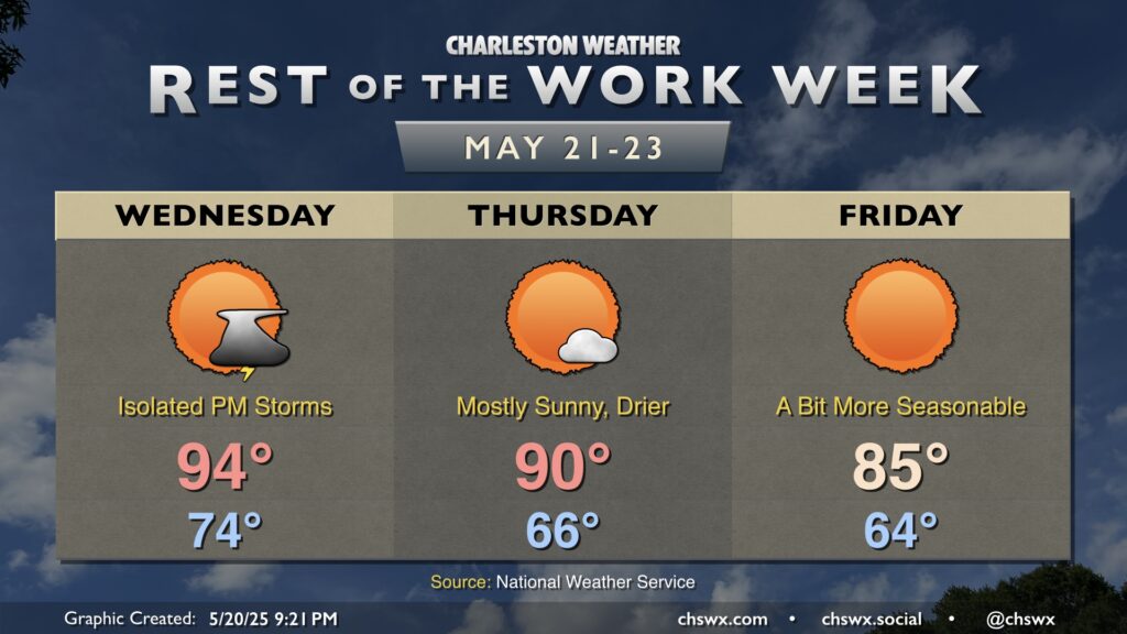
The unseasonable warmth of the past week and change will draw to a close on Wednesday as a cold front approaches the area. We’ll start Wednesday in the mid-70s, warming to the mid-90s in the afternoon. There’s a chance for a storm or two ahead of the front, but it’s conceivable that many of us may not see any rain at all with this frontal passage. If a storm or two can get going, it could turn strong to severe, but the chances are very low.
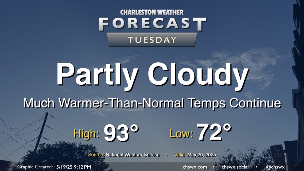
Expect less in the way of cloud cover on Tuesday as the front that helped focus some shower and thunderstorm activity across the area on Monday meanders north and high pressure builds in aloft with plenty of dry, sinking air to be found. We’ll stay on the toasty side of normal for mid-May, with lows in the low 70s warming to the low-to-mid-90s in the afternoon. Dewpoints aren’t terribly out of control, thankfully, so heat indices won’t be too much of a factor, only running about 2-3° or so above the air temperature. That said, it’s still quite warm for this point in the year — the normal high for May 20 is 84°.
We have one more day of scattered storms in store as low pressure aloft opens up into a trough and interacts with the seabreeze in the afternoon. Once again, we get off to a very mild start with lows in the upper 60s expected. Temperatures will head to the mid-80s before scattered storms initiate along and ahead of the seabreeze. Some brief downpours will be possible, but not expecting a repeat of what we saw this past weekend, either.
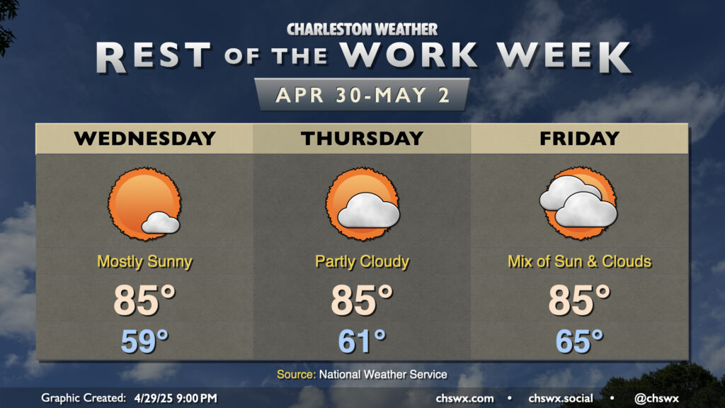
High pressure moving offshore will help send winds a little more southerly for the rest of the work week, and temperatures will respond with a subtle bump into the mid-80s each afternoon. Expect mostly sunny skies to prevail on Wednesday; lows in the upper 50s warm to about 85° in the afternoon, except a little cooler near the coast where the cooler Atlantic waters will modulate the high temperatures a bit.
Another seasonably warm and mostly sunny day is on tap for Tuesday as high pressure remains in control. We’ll start the day on the cool side of normal once again, with lows in the mid-to-upper 50s expected away from the coastline. Then, temperatures warm to the low 80s in the afternoon with plenty of sunshine throughout. Don’t forget the SPF!
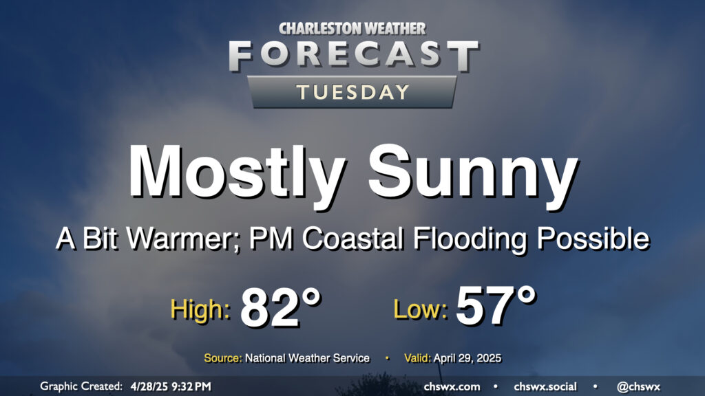
We will still need to monitor tides in the late evening as water levels should peak between 7-7.2’ mean lower low water in Charleston Harbor a little before 10:30 PM. Some minor salt water flooding will be possible an hour or two around the time of high tide as a result, and another coastal flood advisory appears probable. This should do it for this high tide cycle, though, as astronomical influences wane and winds turn more unfavorable starting Wednesday.
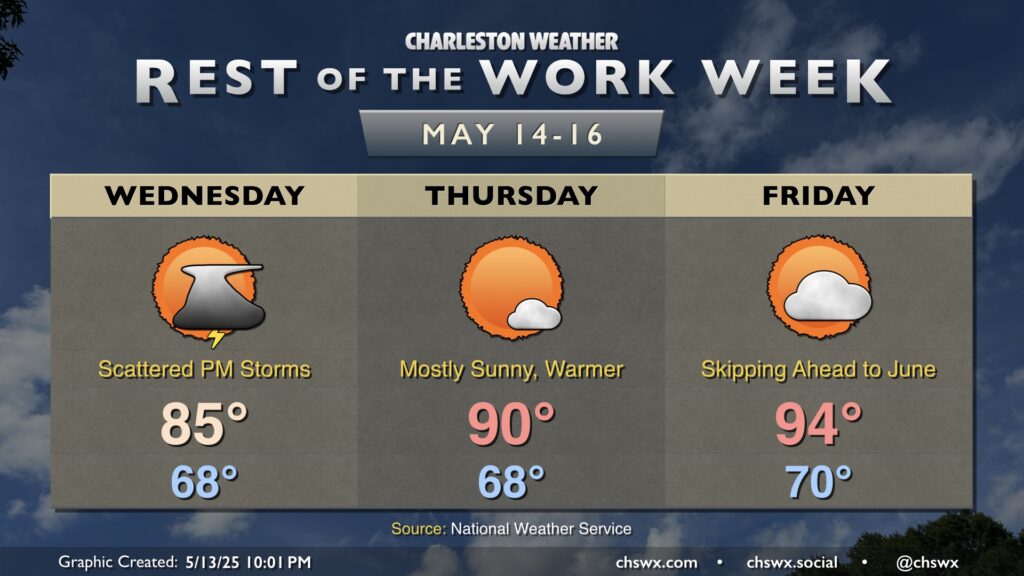
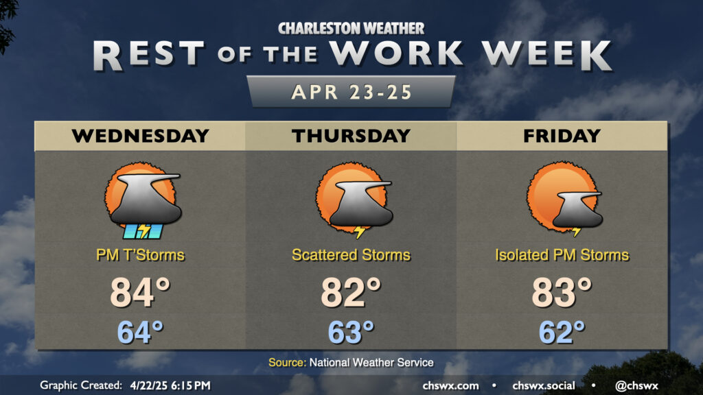
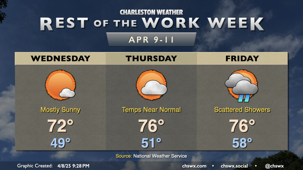
The rest of the work week will be a bit on the unsettled side, especially Wednesday into Thursday, as a stalling front combines with some mid-level energy that’ll be working through the area. Wednesday starts generally quiet with lows in the mid-60s, but showers and thunderstorms should generally fill in starting in the early to mid-afternoon hours as temperatures peak in the mid-80s. Locally heavy rain will be possible, and a strong storm or two with hail and gusty winds can’t be ruled out, especially inland. Keep an eye out just in case, and be ready for evening commute slowdowns.
We’ve got another warm and generally quiet day of weather inbound for Tuesday. Temperatures will, in fact, run a little warmer than they did on Monday despite some additional cloud cover as high pressure aloft begins to break down. Expect generally mid-80s in the metro after a mild start in the mid-60s — temperatures that are climatologically much more in line with early June than they are late April.
A stray shower can’t be totally ruled out as the seabreeze pushes inland, but otherwise, most of us should have one more rain-free day across the area.
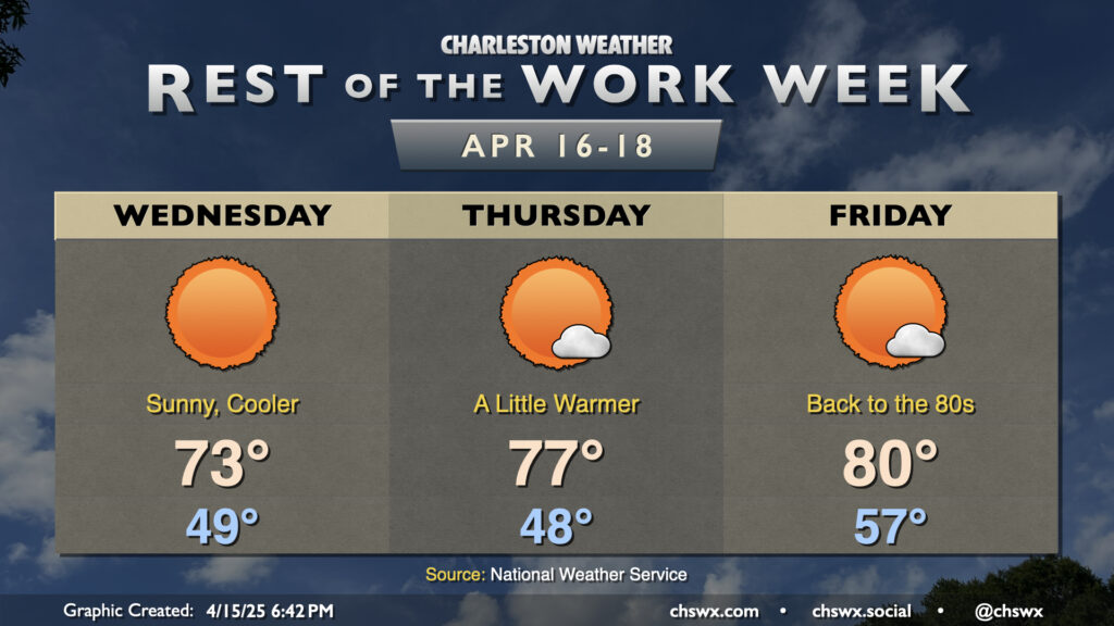
After a cold front clears the area this evening, quiet weather will be the main story through Easter weekend. In the wake of the front, Wednesday will run about 10° cooler than Tuesday did as cooler and drier air moves in. Lows bottom out in the upper 40s, while highs peak right in the low to mid-70s, generally a few degrees below April 16 norms. It’ll be much less windy, thankfully, with winds generally 5-10 MPH.
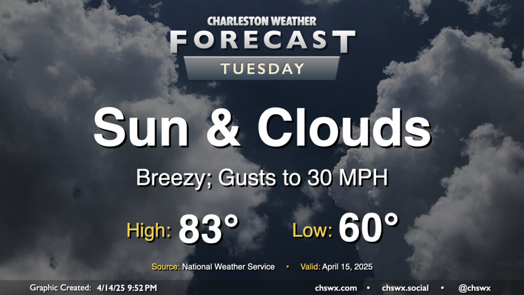
Another warm day is on tap for Tuesday ahead of a cold front that’ll push through later in the afternoon. We’ll start the day around 60°, warming to the low to mid-80s in the afternoon despite increasing cloud cover with the frontal passage. A dearth of deep moisture, though, will keep any rain at bay. It’ll be a breezy day ahead of the front, with gusts pushing 30 MPH at times, so you’ll want to keep that in mind as the bridges may be a little trickier than normal as a result. Winds will calm down in the evening once the front is by, though.
Quiet and generally pleasant weather continues for the next couple days as high pressure remains in control through Thursday ahead of the next front and accompanying rain chance Friday.