The week ahead: March doing March things
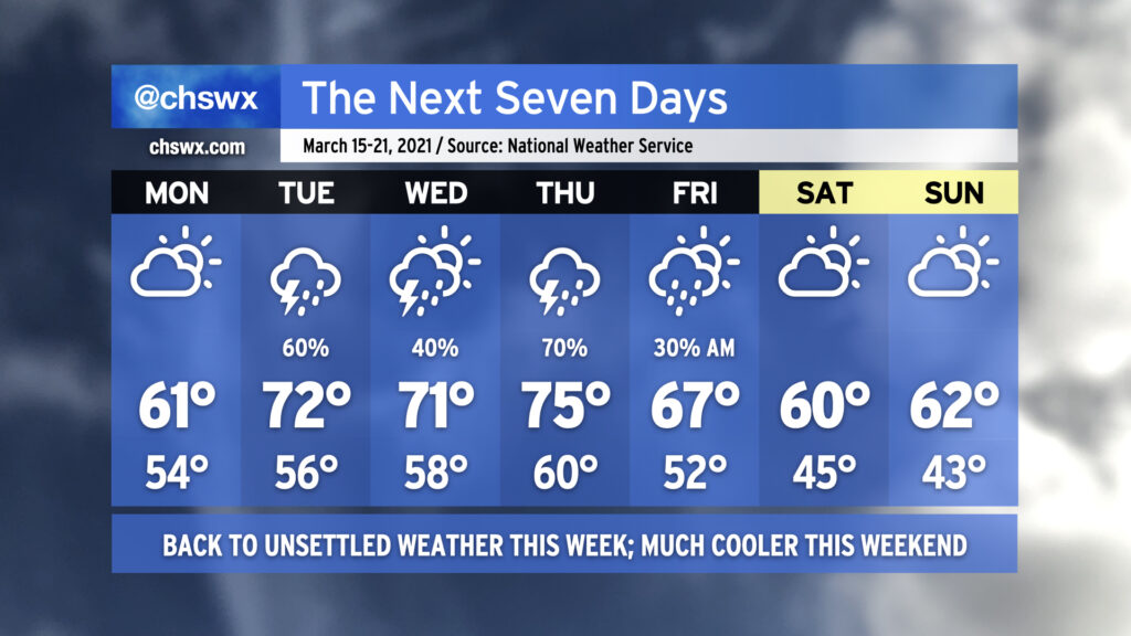
Unsettled weather returns to the picture this week as a series of fronts stall out across the area, bringing shower and thunderstorm chances starting late Monday into much of the rest of the week. Temperatures will be on quite the rollercoaster as well; after topping out at 80° today, we drop back to 61° for Monday as a cold air damming wedge builds southwest across the area, bringing cooler air and gusty northeast winds. Moisture will increase throughout the day, and we will begin to see showers possibly as early as Monday evening, with better rain chances arriving overnight into Tuesday.
After the stalled cold front lifts back north across the area as a warm front on Tuesday (and there is a big question on just how far north it will lift, perhaps making 71° a tad optimistic), low pressure will traverse the area, keeping showers and perhaps a thunderstorm or two in the forecast into Wednesday. We could see a line of strong to even severe storms swing through the area ahead of a cold front on Thursday; this will certainly be something to watch over the coming days, but it’s impossible to nail down the details this far in advance given consequential model timing differences (as one would expect at this range).
By Friday, another cool wedge of high pressure looks to build in across the area from northeast to southwest, keeping cloud cover around and temperatures down in the low 60s, well below normal for mid-March. I wouldn’t be surprised to see some shower chances enter the picture near the coast on Sunday, but right now the NWS forecast is rain-free.
Read more »