The week ahead: A little rain Monday, then mostly quiet — and chilly — until the weekend
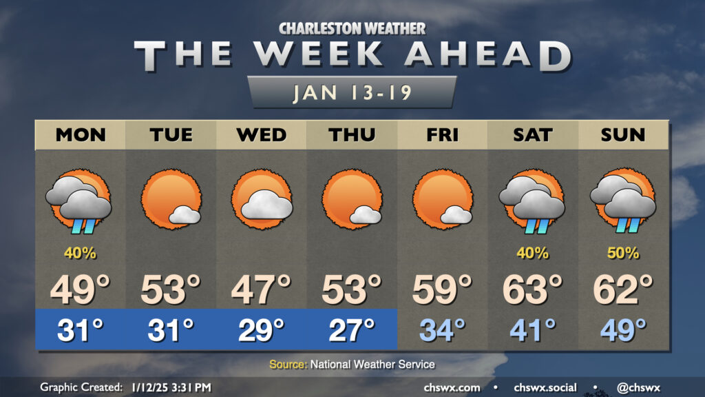
Below-normal temperatures will continue for much of the upcoming week before a bit of a reprieve over the weekend (albeit with rain).
Read more »Below-normal temperatures will continue for much of the upcoming week before a bit of a reprieve over the weekend (albeit with rain).
Read more »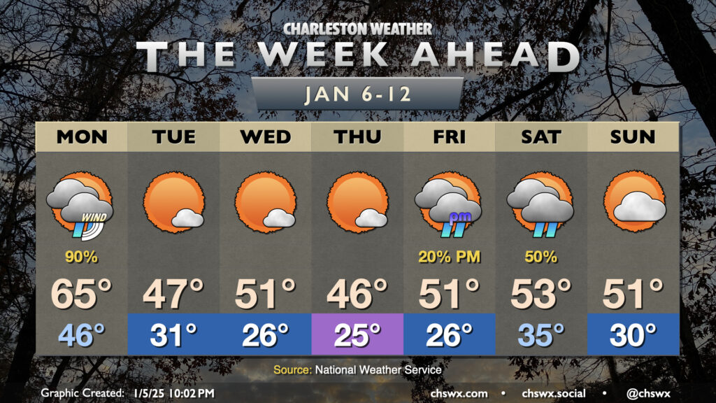
A chilly week ahead is bookended by two winter storm systems that will affect the area. Whether wintry precipitation gets involved remains to be seen; the probability of anything but cold rain taking place in the Charleston metro remains very low.
Read more »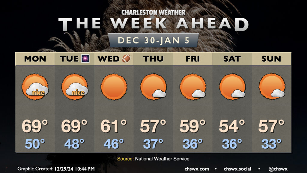
After a windy and wet cold front on Sunday that, thankfully, was devoid of any severe weather in the Lowcountry, we’ll finish 2024 on a warm but quiet note and ring in 2025 with more seasonable temperatures.
Read more »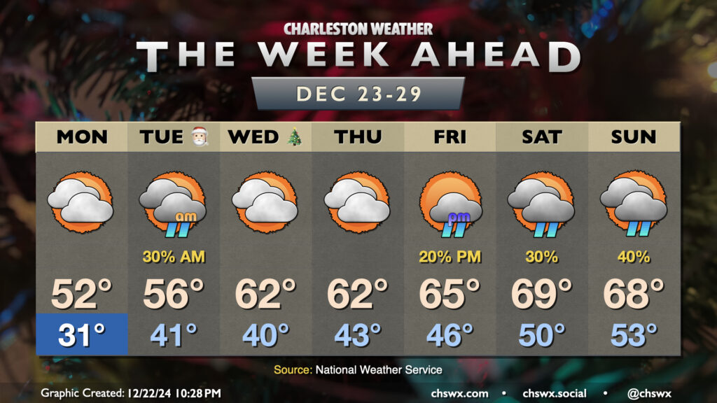
We start the holiday week off on a chilly note. Expect subfreezing temperatures inland of the coast Monday morning, with wind chills in the low 20s expected. We could even see those wind chills drop below 20° further inland, prompting a Cold Weather Advisory for inland Berkeley and Dorchester counties from 4-9am. Cloud cover will build across the area throughout the day Monday, with even a stray shower possible at the coast. Highs will remain well below normal, with low 50s expected at best.
Read more »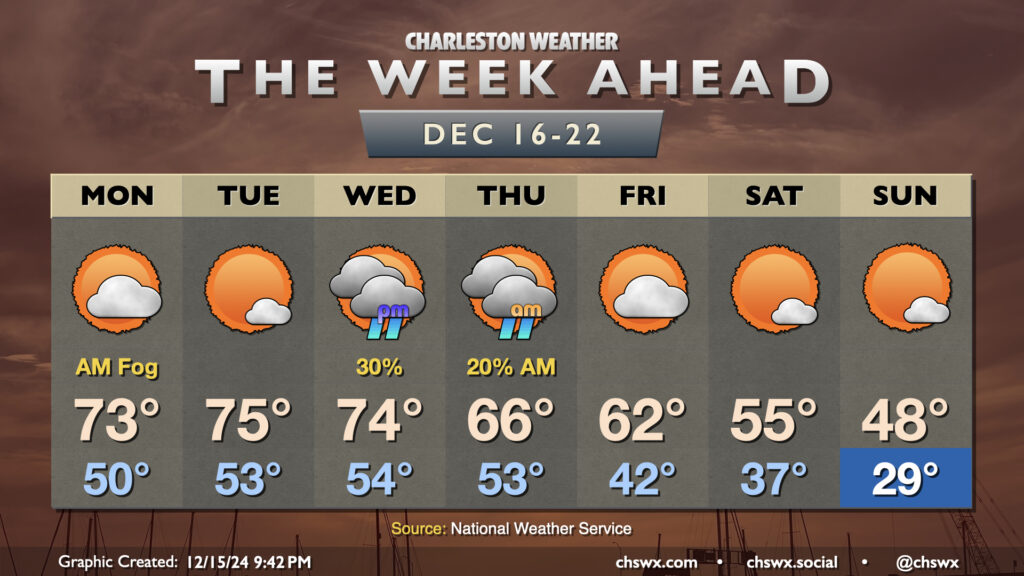
The week ahead will feature another up-and-down cycle of the temperature rollercoaster that has characterized this climatological winter so far. We start the week on the warm side, with temperatures running well above-normal through Wednesday. Monday could start a bit foggy as lows only drop to about 50°. We’ll warm to the low 70s in the afternoon under partly cloudy skies. After what could be another foggy start, expect a little reduction in cloud cover Tuesday afternoon which will lead to what should be the warmest day of the week as highs peak in the mid-70s (and maybe even a bit warmer further inland).
Read more »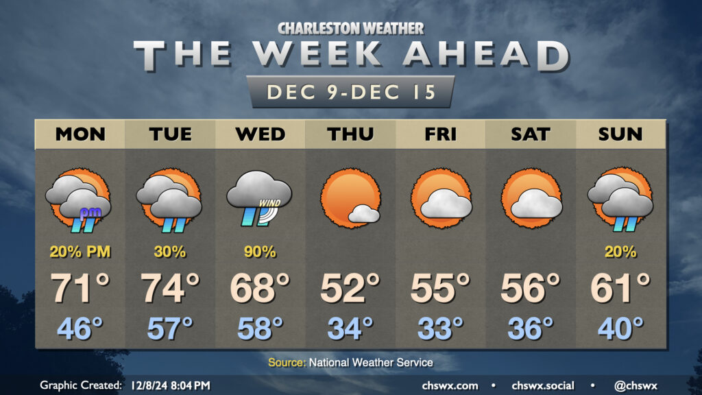
We get off to a warm start this week as temperatures return to the 70s for a few days (albeit with showers, especially Tuesday into Wednesday), followed by another cooldown that sends temperatures back below normal for the second half of the week, though not to the extent we saw last week.
Read more »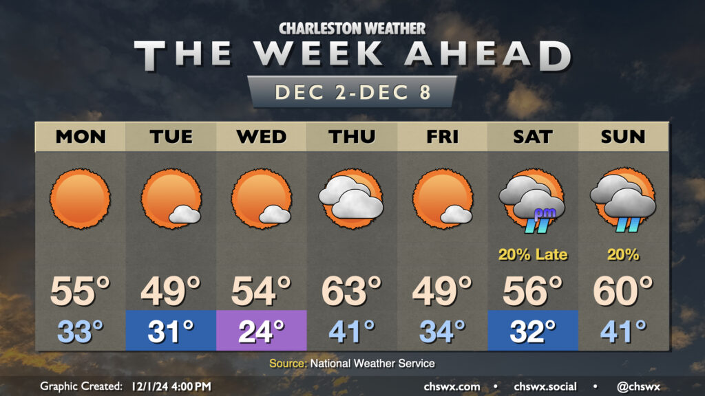
Seemingly on cue for climatological winter, temperatures will remain below normal pretty much all week, with a couple reinforcing shots of cool air to keep us honest interspersed throughout. We stay mostly rain-free, with the possible exception of later Saturday night into Sunday as another front with a few showers looks to move by.
Read more »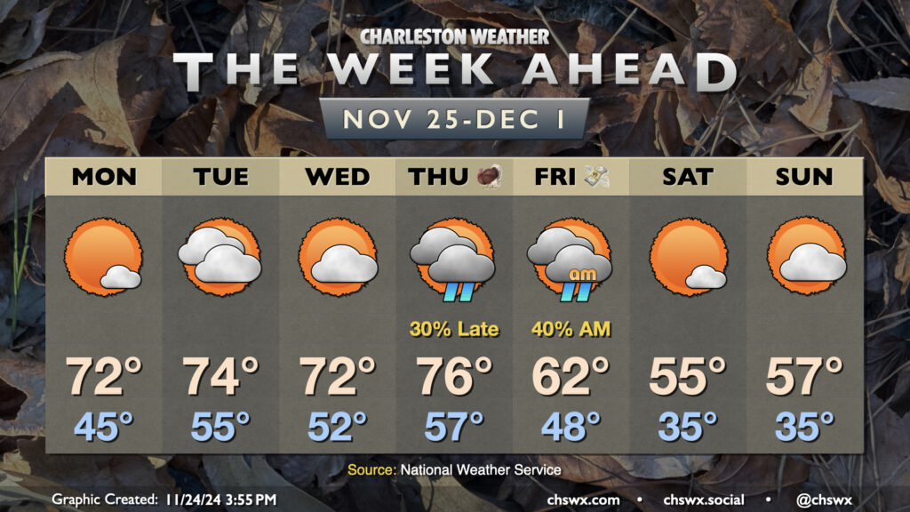
The week ahead will look a bit like last week: starting warm, a mid-week front, and a chilly round of weather for Friday and the weekend (that, in fact, will run even cooler than we did these past few days).
First, though, we’re back in the 70s on Monday as high pressure at the surface starts to move offshore. This makes for a seasonably warm day, starting in the mid-40s and warming to the low 70s in the afternoon. We turn warmer on Tuesday ahead of what should be a dry, fairly weak front, with a start in the mid-50s yielding to highs in the mid-70s in the afternoon under mostly cloudy skies. The front only acts to knock temperatures down a couple degrees, so Wednesday remains warmer than normal with lows in the low 50s yielding to highs in the low 70s in the afternoon.
Thanksgiving Day will be mostly dry, though a stronger front approaching from the west will bring rain chances into the area in the evening through the overnight. It’ll be a warm day, with lows in the mid-to-upper 50s warming to the mid-70s in the afternoon ahead of the rain. Once this front gets through, though, we’ll feel a noticeable change as another shot of cool air moves in. Black Friday’s highs should only peak in the low 60s — some 15° cooler than Thanksgiving — as rain and clouds depart. We’ll stay quite cool heading into the weekend, with perhaps some frost concerns each night as lows on Saturday and Sunday bottom out in the mid-30s, while highs only peak around the mid-50s each day.
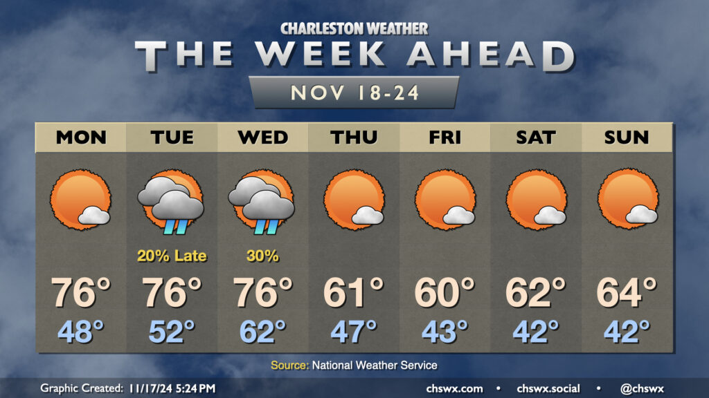
The week ahead gets off to a warm start, but some seasonably cool weather featuring temperatures a few clicks below normal sets in for the second half of the week.
Monday starts with temperatures in the upper 40s. As high pressure begins to shift offshore, we’ll start to see temperatures warm back to the mid-70s in the afternoon under mostly sunny skies. We’ll have one more round of coastal flooding in the morning, but it will not be nearly as severe as what we’ve seen the past few mornings as water levels should only peak around 7.2′ with the 9:31am high tide. Still, expect a few road closures in the more vulnerable trouble spots downtown for a few hours during the commute. From there, winds go more unfavorable and the astronomical impacts from the recent full moon continue to lessen.
The only period of unsettled weather looks to take place later Tuesday through Wednesday as a front comes through (the impetus for our cooldown beginning Thursday). Much of Tuesday should get in rain-free, but will be well on the warmer side of normal with lows in the low 50s yielding to highs in the mid-70s in the afternoon. Shower chances increase around and after sunset, and hang around through midday Wednesday. We’ll see cloud cover diminish as Wednesday goes on, but lagging cooler air will let temperatures back to the mid-70s for one more afternoon after an abnormally mild start in the low 60s.
Cool air begins to kick in overnight Wednesday, and we’ll start Thursday in the upper 40s. Highs on Thursday, though, will struggle above 60° despite considerable sunshine. We’ll repeat this performance on Friday, with an even cooler start in the low 40s. A slow warming trend begins over the weekend, but expect temperatures to remain below normal with highs in the low to mid-60s and lows in the low 40s each day with plenty of sunshine throughout.
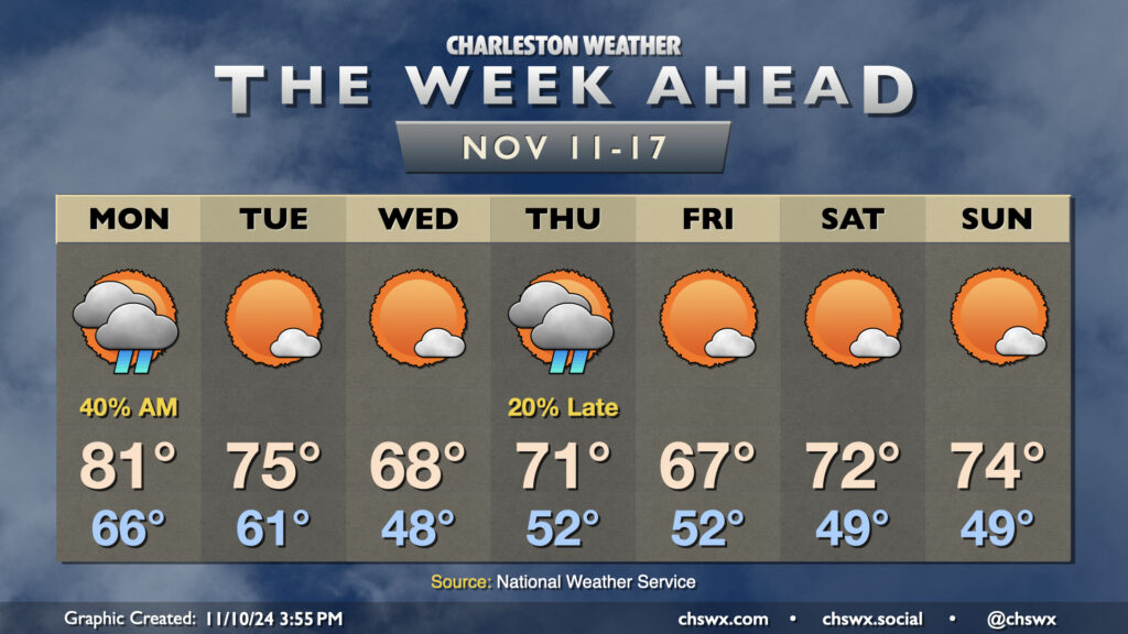
A couple fronts this week will finally restore some order to temperatures that have been well above normal to start November. But first, we’ll get one more day in the 80s on Veterans Day with scattered showers to start the day, which will gradually taper by evening as a cold front moves through the area. This front helps knock temperatures back down to the low 60s Tuesday morning, warming to about the mid-70s in the afternoon under mostly sunny skies.
High pressure to the north will then shift a little eastward, allowing for a wedge pattern with northeasterly winds to start to take shape. This will drive temperatures down to — if not slightly below — normal for Wednesday. We’ll start the day sharply cooler — think upper 40s to around 50° — before warming to the upper 60s, once again under mostly sunny skies.
Another front swings through on Thursday. We’ll turn a little warmer ahead of it, and there may be a few showers associated with it. We start Thursday in the low 50s, warming to the low 70s in the afternoon.
Cooler and drier air behind the front moves in for Friday, and we see highs once again running a touch below normal (upper 60s). The airmass moderates a bit heading into the weekend, which looks quite seasonable and nice with lows in the upper 40s yielding to highs in the low 70s each afternoon under mostly sunny skies.