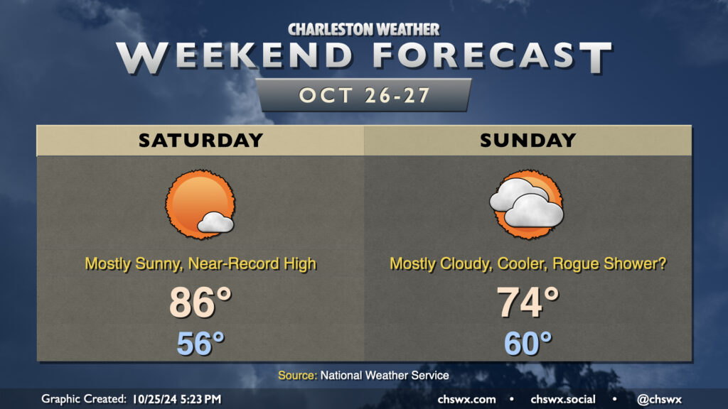
We’ll look to approach a record high on Saturday before a cold front swings through Sunday, cooling us off a bit and increasing cloud cover. (A shower or two may not be out of the question, either.)
High pressure at the surface and aloft hangs on for one more day on Saturday. We start the day in the mid-50s, but compressional heating ahead of the aforementioned front will help drive temperatures into the mid-80s. The record high of 87°, set in 1939, may be achievable at North Charleston, so we’ll keep an eye on this. A few clouds are possible, but sunshine should be the dominant feature once again.
Sunday will feature more clouds than we’ve seen in a while as the ridge moves out and a trough moves in overhead, driving a backdoor front through the region. We start around 60°, but only warm to 74° in the afternoon as winds shift northeasterly. Model guidance still does not totally rule out a shower or two across the Tri-County on Sunday, but most of us should expect the day to stay rain-free. Any rain that falls would be largely insignificant, too, perhaps in the hundredths of inches at best, so definitely not anything to get your hopes up over (if rain’s what you’re looking for, anyway).
Heading into next week, we stay cool for Monday but start to warm up again on Tuesday and beyond. Halloween will be on the warm side with lows in the low 60s warming to around 80° in the afternoon under mostly sunny skies. Alas, no sweater weather is in the foreseeable future as we head into November.
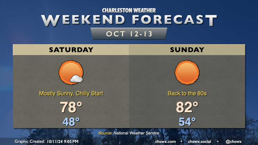
We have an outstanding weekend of weather ahead as high pressure remains in control. After our first low in the 40s Friday morning, Saturday starts back in the upper 40s once more, but winds will start to swing around to the south and that will begin to help moderate the airmass a bit. Expect just a few passing clouds Saturday afternoon, but otherwise, lots of sunshine will be the rule.
Sunday will be a warmer day. We start the day in the mid-50s, warming back into the low 80s in the afternoon under mostly sunny skies. It’ll be a very comfortable low 80s, though, as humidity will be a non-factor with dewpoints in the mid-50s.
I hope you get a chance to enjoy this wonderful weekend of weather!
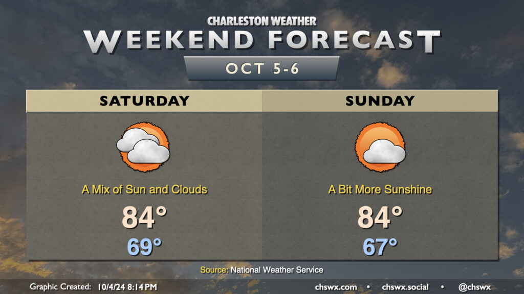
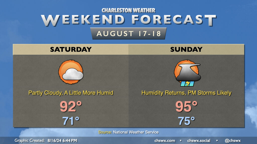
Quiet weather is expected this weekend as high pressure remains in control. Friday’s occasional showers will be a thing of the past on Saturday as cloud cover gradually thins throughout the day. We start Saturday in the upper 60s, warming to the mid-80s in the afternoon.
More sunshine is in the offing for Sunday as a trough of low pressure aloft moves out and a little bit of ridging moves in. We start the day a touch cooler, generally in the mid-to-upper 60s, warming once again to the mid-80s in the afternoon under partly cloudy skies.
The next front, which arrives with little fanfare on Monday, should finally bring a shot of more fall-like air into the area for next week, with lows possibly dipping into the 50s by next Thursday. Overall, the outlook is for generally quiet and dry weather for at least the next several days.
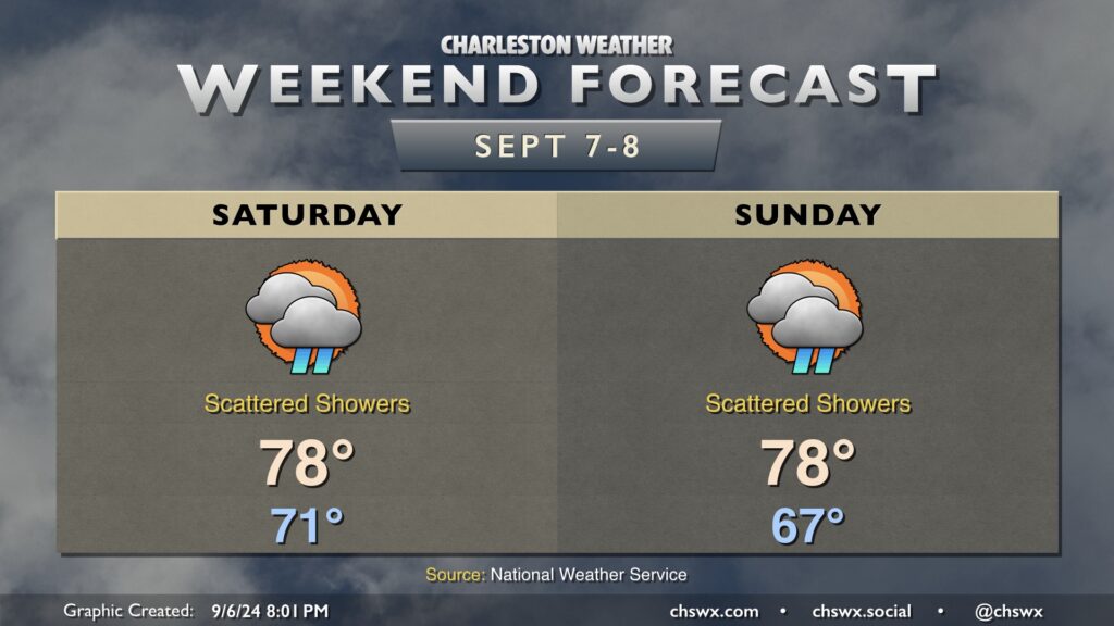
Quieter weather is in store for this weekend (though one could argue the bar is very low for that) in the wake of Helene. It’ll stay warm and muggy, though, as we head down the home stretch of September.
Saturday starts in the upper 60s to around 70°, warming to the mid-80s in the afternoon as a brief shot of cooler and drier air gets us off to a relatively cooler start. It’ll still feel closer to 90°, though, when factoring in dewpoints around 70-71°. The airmass modifies quickly, though, and by Sunday, we’ve got a late summer-ish day with lows in the low 70s warming to the upper 80s that’ll feel more like the mid-90s in the afternoon.
We have a few more days of the muggy airmass before another front sweeps through for the middle of next week, cooling us off pretty nicely as we head through the first week of October.
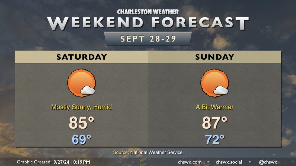
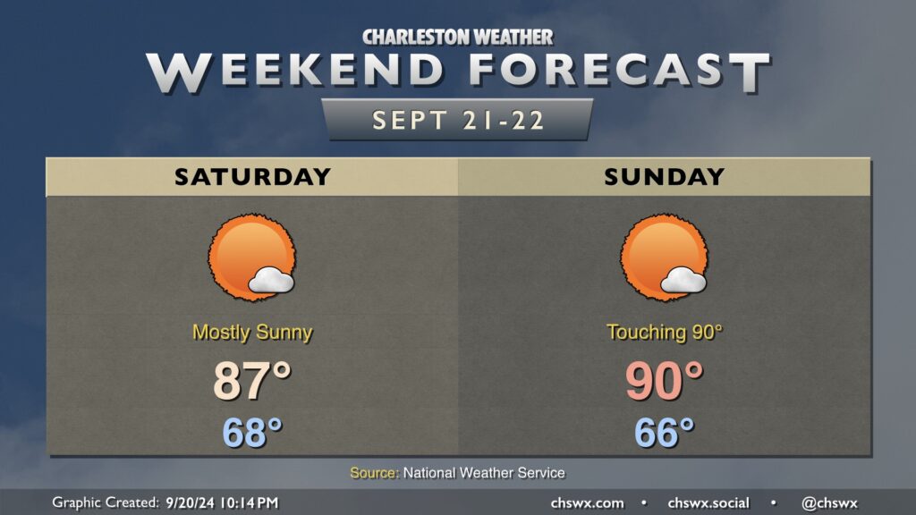
It’ll be a quiet, bright, sunny, and warm weekend in the Lowcountry, with a bit of a callback to summer despite the onset of the autumnal equinox on Sunday.
We start Saturday in the upper 60s, warming to the mid-to-upper 80s in the afternoon under mostly sunny skies as ridging aloft builds in. That ridge gets even a bit stronger for Sunday, and could send highs to around 90° for the first time since September 1, when we reached 91°.
The only real fly in the ointment weather-wise won’t even necessarily be all driven by weather, but rather by high astronomical tides thanks to the recent full moon. Water levels in Charleston Harbor look to peak well into moderate, but just shy of major, flood stage (7.9’) around the 11:14am high tide. As a result, get ready for more road closures like we saw mid-morning on Friday. Sunday should offer similar tide concerns around the midday high tide. Keep an eye out for Coastal Flood Advisories from the National Weather Service.
A complex forecast lies ahead this weekend as we monitor for the potential for low pressure to spin up off the coast, which has a shot at potentially becoming tropical as it approaches the coast early next week.
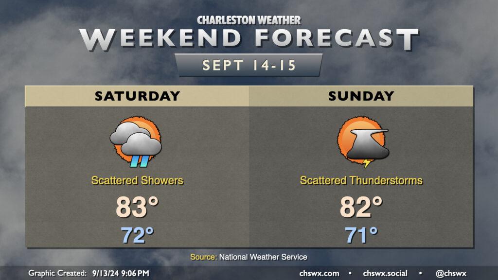
A showery and cool weekend awaits as a trough remains draped over the eastern US, driving disturbances through the area and keeping temperatures well below normal for this point in the year.
Saturday starts in the low 70s, warming only to the upper 70s for the first time since May under mostly cloudy skies. Shower chances will be highest in the morning and will taper, but not completely cease, during the day. Rainfall amounts should be generally light, though you can never totally rule out a pocket of heavier rain or two.
Sunday’s rain chances will tick up some as the day goes on as another disturbance moves through. It’ll be another cooler-than-normal day, with a pretty seasonable start in the mid-to-upper-60s before highs once again top out in the upper 70s in the afternoon. A rumble of thunder isn’t totally out of the question as the stationary front continues to hang out, but otherwise, just be ready for some showers at times.
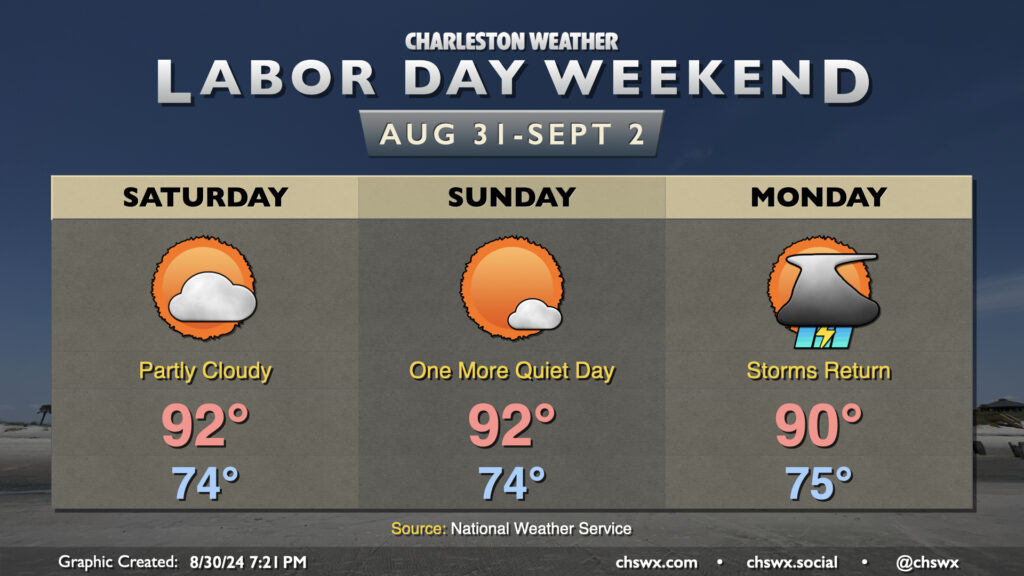
It’s a Meat Loaf-like Labor Day weekend this year: Two out of three ain’t bad. We’ll continue this stretch of warm but mostly quiet weather (aside from a stray shower on the seabreeze) for Saturday and Sunday. Expect to start each day in the mid-70s, warming to the low 90s in the afternoon. Heat indices will generally run in the upper 90s — certainly still hot, but it could (and has!) been much worse.
Attention then turns to a front that will move into the area on Monday. We’ll see the risk for showers and thunderstorms increase throughout the day as the front sags south into the region. Temperatures will peak around 90° one more time before the front ushers in cooler air and continued unsettled weather as we get into the working portion of next week. Severe weather doesn’t look to be a major concern, but we could see brief periods of heavy rain and lightning from any thunderstorm that fires. Remember: when thunder roars, go indoors!
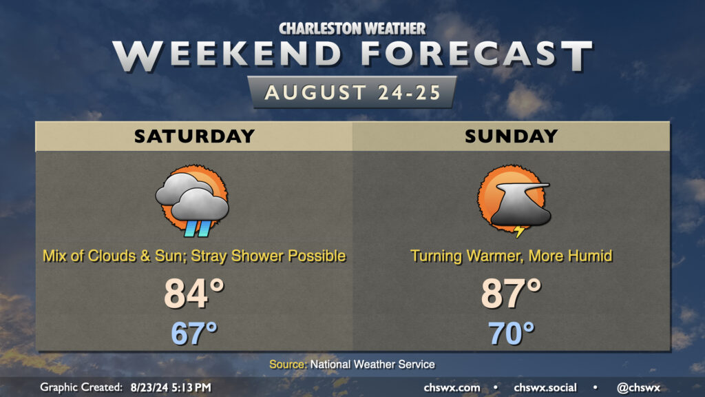
Cool high pressure will hang tough over much of the Carolinas heading into the weekend, though coastal areas could run a little warmer and more humid depending on the position of a stationary front/coastal trough nearby. The trough keeps cloud cover in the forecast for Saturday in particular, and that combined with northeasterly winds will keep temperatures down into the mid-80s in the afternoon after another mid-60s start. A stray shower or thunderstorm will be possible Saturday, particularly closest to the coast, with the nearby trough. A little more humidity creeps into the area for Sunday as winds just off the deck turn more onshore. It remains to be seen just how deep the moisture becomes with some fairly serious differences in model guidance showing up, but ultimately be ready for an isolated storm or two Sunday afternoon. We will see dewpoints return to the low 70s; as high temperatures head to the mid-to-upper 80s, that will yield heat indices in the low 90s. Nothing terribly heinous, though certainly not as comfortable as it has been.
While northeasterly winds continue around the high pressure wedge, the risk for coastal flooding around times of high tide has ended as the tidal departures will stay below flood stage (though they will creep into action stage from time to time). One less thing to worry about, at least. Enjoy the weekend!
High pressure will gradually give way to another cold front this weekend, bringing humidity back to the picture particularly Sunday. However, the return to mid-70s dewpoints will be brief as slightly drier air moves back in behind the front next week.
Saturday will run a little warmer than Friday did. After another cool-ish (relatively speaking) start in the low 70s, temperatures warm to the low 90s in the afternoon as dewpoints creep back up to the upper 60s. This will make it feel more like 95° or so — not a huge jump, but certainly warmer than it’s felt the past couple days. Expect rain-free conditions on Saturday with one more day of high pressure in control before it cedes ground to the approaching front on Sunday.
Sunday starts warmer — back to the mid-70s — and warms to the mid-90s in the afternoon. Dewpoints in the low to mid-70s will yield heat indices around 100-102° at the height of the afternoon. As the seabreeze moves inland and the front draws closer, expect showers and thunderstorms to develop. Guidance doesn’t show much to write home about with the seabreeze activity — generally scattered coverage — but a round of thunderstorms ahead of the front looks like a good bet as we get into Sunday evening. Shear and instability will be favorable for a few severe thunderstorms, with damaging wind gusts the main concerns (though some hail can’t be ruled out, either). If we get greater coverage of seabreeze storms, that could lower the severe weather risk locally, but we’ll need to see how that materializes. Keep an eye on forecast updates for Sunday evening, just in case.