Thursday: A few storms possible as low pressure passes offshore

Thursday could feature a few showers and storms brushing the coast as low pressure tries to organize along a stationary front that’s been lingering offshore for the past few days. It’ll otherwise be a fairly standard warm June day — lows in the low 70s yielding to highs around 90° in the afternoon under a mix of sun and clouds. Dewpoints in the upper 60s will help keep heat indices from getting too far out of hand, thankfully.
Friday & the weekend: Turning warmer before afternoon thunderstorms return Sunday
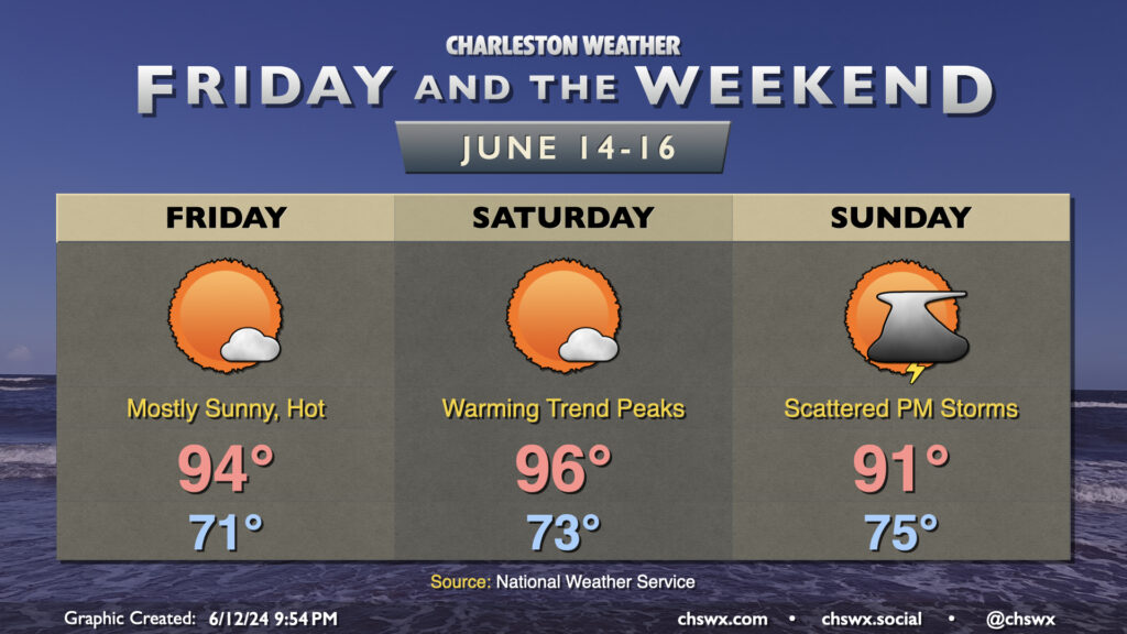
Low pressure departs the area as ridging builds overhead Friday into Saturday, yielding a couple hotter-than-normal days before moisture builds back in and provides the fuel for seabreeze storms beginning Sunday afternoon. We’ll start Friday in the low 70s, warming to the mid-90s in the afternoon as ridging begins to build into the area. Saturday turns even warmer, with mid-to-upper 90s possible as a dry front gets nearby. If you’re looking for thunderstorms for heat relief, you may start to get your wish on Sunday as moisture draws back northward, giving the seabreeze something to work with as it pushes inland. We’ll start in the mid-70s and warm to the low 90s, a few degrees cooler than Saturday. Expect to hang around the upper 80s to around 90° each day as we head into next week, too, along with the persistent standard 20-30% chance of afternoon thunderstorms.
Tropical update: A couple areas to watch, including the nearby low
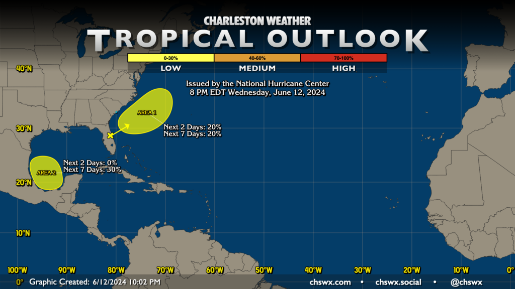
The National Hurricane Center is keeping an eye on the low that’ll run parallel to the coast over the next couple days for possible tropical development. Low pressure systems spinning up on stalled fronts are often a source for early-season storms. As of the 8PM outlook, NHC gives it a 20% chance to organize into something tropical — not terribly high. And even if something does form, it’ll be headed away from here. All good.
The second area of interest will flare up in the Bay of Campeche as we head into the weekend. It has a 30% chance to develop over the next week. Global models are pinging on something flaring up in this area, but the early indication is that it’s not a concern here at home. All in all, these areas serve as a good reminder that yes, we are in fact in hurricane season now. The best time to get prepared is now, while nothing is on tap for our neck of the woods. Visit hurricane.sc for preparedness information and to look up your evacuation zone — zones changed for 2024, so be sure you’re up to date on where you fall evacuation-wise.
Follow my Charleston Weather updates on Mastodon, Instagram, Facebook, Bluesky, or directly in a feed reader. You can also get daily audio updates via the Charleston Weather Daily companion podcast, available wherever fine podcasts are listed. Do you like what you see here? Please consider supporting my independent, hype-averse weather journalism and become a supporter on Patreon for a broader look at all things #chswx!