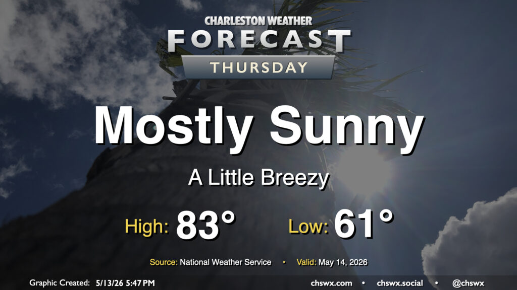
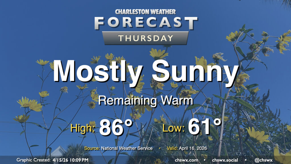
A cold front will swing through early Thursday with high pressure to build in behind it. Temperatures will start in the low 60s, warming to the low-to-mid-80s in the afternoon with northwesterly winds around 10 MPH. The downslope flow will dry out the atmosphere pretty nicely, allowing for mostly sunny skies with maybe a few fair weather clouds. The drier air will make the 80s highs feel a little more comfortable, too. Overall, it’s a good day to try to get some sunshine in the midst of the daily grind.
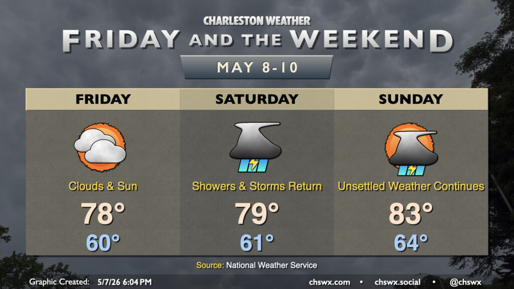
We’re back in the saddle here at @chswx HQ and looking at a quiet Friday before conditions turn unsettled once again this weekend as the front that’s helped to bring us today’s rain starts to wobble back northward.
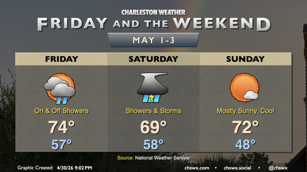
After completing what should go down as the second-driest April on record (only by virtue of measurable rainfall over the past two days), we will get May off to a more unsettled start with some much-needed rain followed by a cool but sunny Sunday. We will also need to keep an eye on tides for possible coastal flooding concerns into the weekend.
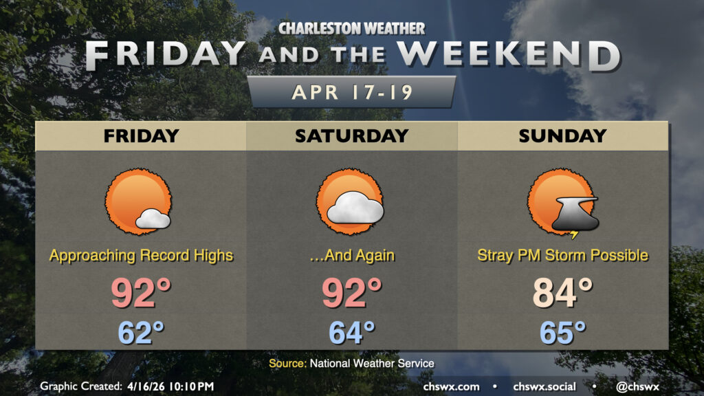
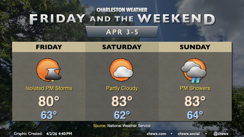
After one more mostly sunny and dry day Friday, the pattern finally turns a little more unsettled starting Saturday as a cold front advances toward the area. This front will help stir up some showers and maybe some thunderstorms later Saturday into Sunday. Rainfall amounts will generally be light — a quarter-inch may be awfully generous from this setup — but everything helps.
Temperatures Friday and Saturday run in the mid-to-upper 80s in the afternoons after starting in the upper 50s Friday and the low-to-mid-60s on Saturday. From there, a backdoor cold front looks to sink southward across the area on Sunday, which will take temperatures down a few degrees with highs in the low-to-mid-80s expected. With the exception of Monday, though, generally expect warmer-than-normal temperatures to close out April.
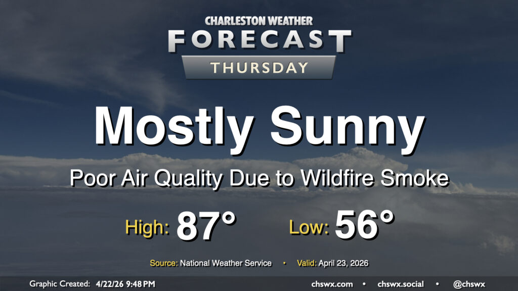
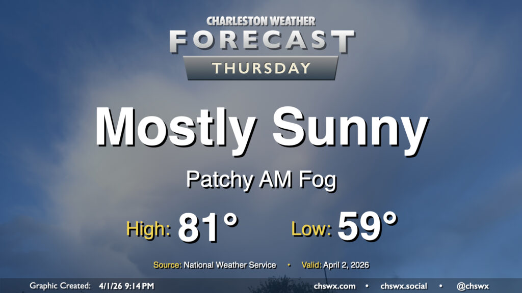
High pressure will remain in control on Thursday, keeping mostly sunny skies in place. It won’t be all sunshine, though, as smoke from nearby wildfires in Georgia drifts into the area, which could have negative impacts on air quality. An Air Quality Alert is in effect for the Lowcountry through Thursday evening as a result; people who have sensitivities to poor air quality should limit time outdoors. Temperatures will take another step up as southwesterly winds help pump in warmer air; expect lows in the mid-50s to warm to the mid-to-upper 80s in the afternoon.
Well, we are running out of ways to tell y’all that it’s going to be warm and dry. High pressure remains the main weather driver across the area, keeping temperatures warmer than normal and rain chances virtually nil. We’ll start the day in the low 60s, warming to the mid-80s in the afternoon away from the coast, where onshore flow from the south will help keep temperatures pinned to the upper 60s. Expect downtown to peak a few degrees cooler, generally in the upper 70s to low 80s depending on your proximity to the water.
There are no weather concerns this weekend for outdoor activities across the Lowcountry with seasonably warm temperatures and mostly sunny skies. The main weather concern remains the building drought across the area, with severe drought across our part of the Lowcountry.
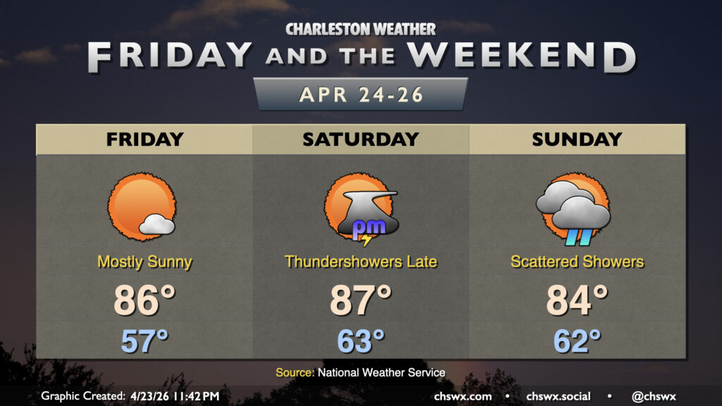
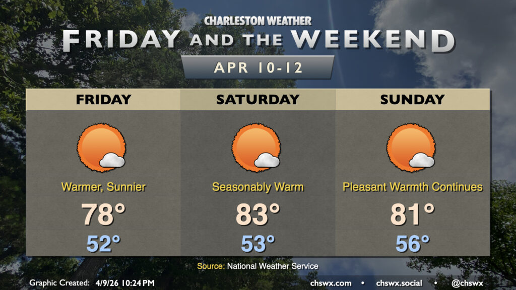
Temperatures Friday will be the coolest of the set, topping out in the upper 70s to near 80° with plenty of sunshine. Saturday will be the warmest day with more southerly winds expected to help drive temperatures into the low-to-mid-80s. Winds turn more onshore on Sunday, and that will send temperatures a touch lower as a result — but still warm in the low 80s.
Warmer-than-normal temperatures will continue for a few more days across the Lowcountry before a sharp front cools us off to start the first full week of April.
Seasonable warmth continues for Thursday as well as heading into the weekend with high pressure in control for a few more days. We’ll start Thursday in the upper 50s to near 60°, perhaps with some patches of fog again in the morning. Any fog dissipates fairly quickly after sunrise, and temperatures will head back into the low 80s under mostly sunny skies.