Lovely Valentine’s Day turning warm and somewhat unsettled for SEWE weekend

We’ve got a nice Valentine’s Day coming up — at least weather-wise. (How nice your Valentine’s Day ends up being will largely be determined by other factors.) However, an unsettled pattern with periods of showers awaits us for the weekend.
About last night…
Before we get into the weekend forecast, can we just take a moment to soak in the beauty that was last night’s sunset?
How it happened
There were a couple key weather factors that played into what allowed this sunset to be so epic.
Thin, high clouds
The Charleston area was on the tail end of an absolutely screaming 250mb jet streak, which the Rapid Refresh model analyzed at over 200 knots in spots near the Delmarva Peninsula. This was roughly located around 33,500 feet, right where jetliners typically cruise.
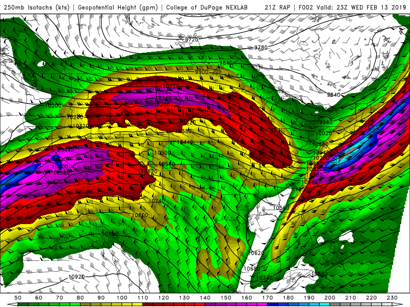
We were situated in the right-rear entrance region of the jet streak, which induces lift. There was meager moisture in the atmosphere (more on that in a minute), but enough to generate a thin shield of cirrus clouds that covered the eastern half of the Carolinas.

Dry air in much of the atmosphere
Much of the rest of the atmosphere was very dry after a cold front pushed through early in the day, allowing high pressure to build in from the west. Northwest flow around the high was deep, causing downsloping off the Appalachians that dries out and heats up the air through compression. This led to a pretty nice day, and is depicted well on this very dry 00z weather balloon sounding from the NWS Charleston office.
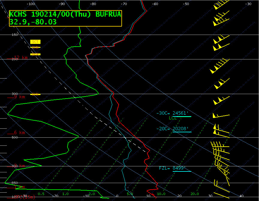
You’ll note that the green line (dewpoint) and red line (temperature) are very far apart toward the bottom and middle parts of the sounding, all the way up to 300 millibars (roughly 31,000 feet). This dry air precluded any sort of low or mid-level cloud coverage from forming. Essentially, the vast majority of the moisture in the troposphere was found above 31,000 feet last night, and this combined with the strong jet energy aloft allowed for the cirrus band to form.
Thanks to this dry air, the lack of cloudiness in the low and mid-levels allowed for sunlight to come through unobstructed between the horizon and the cloud deck aloft. Sunlight at the horizon passes through much more atmosphere, and as a result, is scattered and refracted much more than midday sun, making for the beautiful colors you see at night.
The Storm Prediction Center has an excellent paper on sunsets by now-retired meteorologist Stephen Corfidi that is most certainly worth a read if you want to geek out more!
A warm and occasionally unsettled SEWE weekend on the horizon

High pressure will slip east of the area during the day today as we become oriented under a fast west-to-east (“zonal”) flow aloft. On the back side of this high, we will see temperatures begin to rise into the 70s ahead of a cold front. Moisture return will improve ahead of a low pressure system that forms along a front to the north; this will drive the front southward, with it stalling out somewhere over the Carolinas late in the weekend. With this will come periods of showers, but no washout.
Friday: Last dry day
Friday looks to remain dry for much of the day. Temperatures in the 70s — over 10° above normal for this time of year — will be achieved despite mostly cloudy skies.
Later in the evening, a wave of low pressure looks to develop along the front, which may bring a few scattered showers into the area. The best rain chances are closer to midnight and early in the morning Saturday.
Saturday: Warm but potentially unsettled at times
The aforementioned wave of low pressure looks to slip parallel to the NC/SC border during the day on Saturday. This will raise the specter for some shower chances this far south during Saturday morning, decreasing as the day goes on. This will also drive the front further into the area. How far south it gets is less clear, and as a result, there is high bust potential for temperatures Saturday night. Right now, NWS has us on the warm side of the front, which keeps lows in the 50s overnight Saturday into Sunday morning.
Sunday: Looks warm, but high bust potential
Sunday is a tricky forecast. Right now, expect a few showers and a continuation of our warm temperatures, with highs in the 70s in the afternoon (based on the latest NWS forecast).
How Sunday plays out is highly dependent on how far south cold air damming (which is indicated on the NAM and GFS) may try to develop. Moisture atop this wedge of cool air could induce some showers Sunday morning before the front lifts north as a warm front. There is the potential for Sunday morning to be much cooler than 53°, and we’ll want to watch that.
The other weather feature to watch is a low pressure system developing and moving ENE along the Ohio Valley. Depending on how close it gets, this will have impacts not only on temperatures (as we’d be in the warm sector of the storm system) but also on how much rain we might see.
Bottom line: Stay tuned. I am not expecting a washout by any stretch, but be ready with the rain gear at times this SEWE weekend.