It’s still warm, but a pattern change is coming

Our stretch of very warm temperatures continues into Thursday, but changes in the pattern are afoot that will show winter reasserting itself especially as we get into next week.
Just how warm has it been?
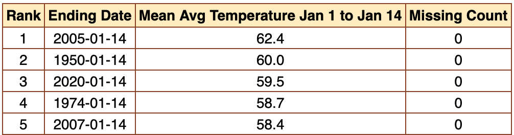
It’s felt unusually warm, for sure, but to put it in perspective, we need to dig back into the numbers a little bit. Said dig reveals that the first two weeks of 2020 are the third-warmest on record at the airport, with an average temperature of 59.5°. The only two warmer starts to a year are in 2005 and in 1950, when the average temperature was 62.4° and 60.0° respectively.
We’ve already had seven days over 70° in the first two weeks as well, but several years have had more days above 70° to start the year (2005 takes the cake, with 12 days in the first two weeks at 70° or above). So, what’s driving this average temperature increase? Well, it’s our lows that are the story here.

When looking at the number of days the minimum temperature has been at 60° or above, January 2020 is starting the year at a record pace. Four days at 60° or above to start the day ties the record set in 1972. Only six times has the low been above 60° more than twice in the first two weeks of the year, too.
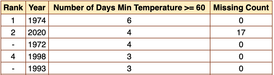
When looking at January at a whole, 2020 is already in second place for number of days with a 60° low, too. And while 1974 is the front-runner at six days, the current forecast all but assuredly will move 2020 into a tie for first place.
Anyway, this is all about to change pretty drastically.
We’re bringing winter back

The pattern we’ve been living in — ridge in the Southeast with troughing in the west — is about to flip the script. We’ll see our first intrusion of cooler air starting Friday as a cold front swings through during the day Thursday. This will be followed up by a warmer-than-normal weekend ahead of another reinforcing shot of cold air. By Monday, highs will struggle into the low 50s. It’ll be even cooler Tuesday, with lows below freezing and highs that may not leave the upper 40s.

We look to stay in this pattern through the end of January. The latest Climate Prediction Center outlook shows below-normal temperatures are largely favored to continue as we remain in the chilly and somewhat unsettled pattern.

The Climate Prediction Center is also expecting more precipitation than normal as we get into the last couple weeks of January. It remains to be seen if this means plain rain or something a little more frozen (given the below-normal temperatures also in the outlook for this timeframe).
Some of you more astute model watchers may have seen some ensemble members indicate snow potential in the long range. This is the time of year where we will see some models try to put together a wintry solution for the Lowcountry where one may not ultimately exist. (It happens frequently, rarely with the wishcasted results.) We’ll watch the models to see if they sniff out something more interesting more consistently, but for now, don’t get your hopes up on any wintry precipitation.
Follow my Charleston Weather updates on Mastodon, Bluesky, Instagram, Facebook, or directly in a feed reader. Do you like what you see here? Please consider supporting my independent, hype-averse weather journalism and become a supporter on Patreon for a broader look at all things #chswx!