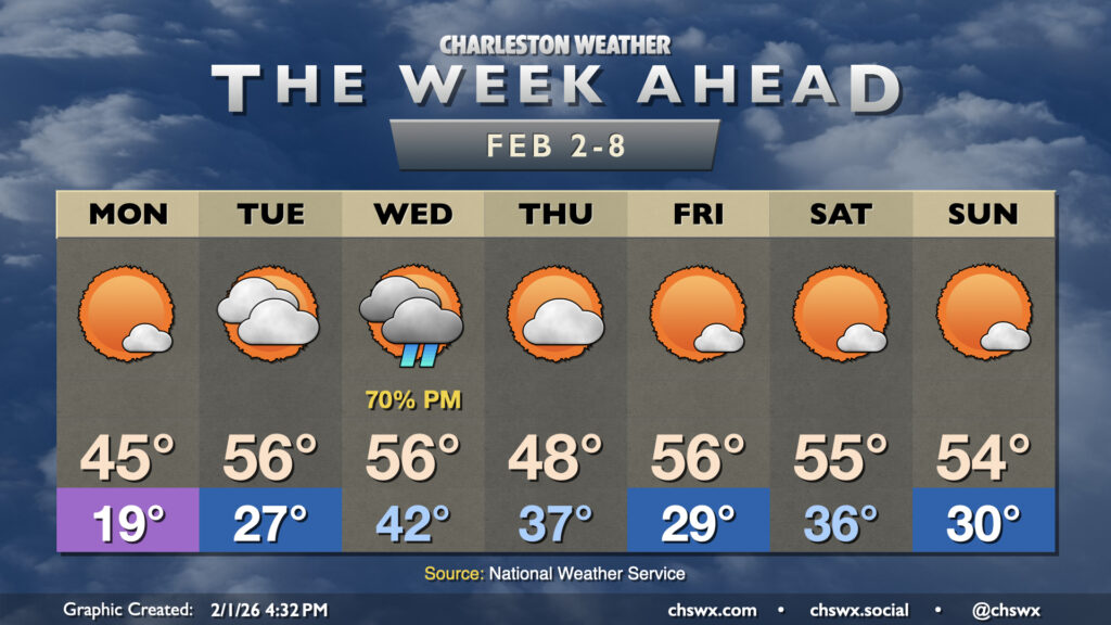
Our run of cooler than normal temperatures that closed January will continue for the first week of February, but a repeat of the past couple weekends of wintry intrigue, mercifully, is not expected.
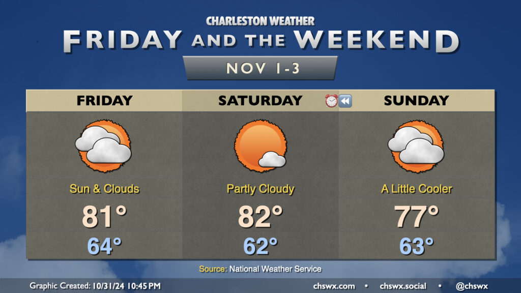
Unseasonable warmth rolls right into November as temperatures for Friday and Saturday remain upwards of 8-10° above normal for the start of the final month of hurricane season before a front cools things off slightly for Sunday. Overall, expect highs in the 80s on Friday and Saturday after starts in the low to mid-60s. A mix of sun and clouds will continue across the area, with perhaps a bit more sunshine on Saturday before a backdoor front moves by on Sunday, cooling us off a few degrees and thickening cloud cover once more.
Measurable rainfall remains extraordinarily difficult to come by; a few spots have had some sprinkles from time to time, but that’s about it. In fact, October 2024 is going to go down as the second-driest October on record with only 0.03″ of rain measured at the airport on October 4, and only traces of rain on a few occasions since then. This is second only to October 2000, when only a trace of rain was recorded that month. Records at the North Charleston climate site at the airport go back to 1937. As you can imagine, drought is developing over the area, and this week’s Drought Monitor puts much of the Lowcountry into moderate drought, while the rest of the state (except for a sliver of Lancaster and York counties) is now into Abnormally Dry conditions. We could certainly use a bit of rain, and none seems likely through at least the middle of next week.
After another very warm day Tuesday, a cold front will get through the area overnight and into early Wednesday, bringing an all-too-brief round of much drier air to the area. (A few showers are possible too.) We start the day in the mid-70s, but as the somewhat cooler and drier air moves in, we’ll find highs will top out generally in the upper 80s. Lower dewpoints, though, are what will make upper 80s to around 90° much more tolerable. We should see dewpoints mix down to the low 60s for the first time since June. Heat index won’t be a factor, and it should overall be a comparatively nice afternoon to do some things outside for a change.
Temperatures look to stay well on the warm side of normal heading into the weekend, especially Wednesday and Thursday before a front late Thursday brings temperatures back down a little bit.
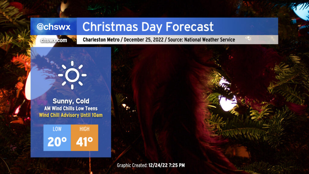
After record-breaking cold on Christmas Eve, we have another round of cold — but perhaps not quite as cold — weather for Christmas Day.
We begin the day with another Wind Chill Advisory as another round of low teens wind chills is forecast across the area. Air temperatures will drop to around 20°, with another dip into the teens possible further inland as well as in more rural areas. The good news is that after what should amount to about 40 consecutive hours below freezing, we will finally exceed the melting point by early afternoon, which will give us some much-needed thaw time. Skies will be mostly clear throughout the day, and at least some unfiltered sunshine will help it feel not as bitterly cold as it was on Saturday, though wind chills will still, at best, run in the low 30s.
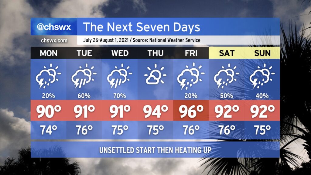
After a very rare weekend of relatively low humidity (for late July, anyway) we’ll see dewpoints return to the low to mid-70s as tropical moisture builds back into the area. Monday will feature isolated showers and thunderstorms primarily driven by the seabreeze, but as we get into Tuesday and Wednesday, a low pressure system — labeled by the National Hurricane Center as Invest 90L with a 50% chance of tropical development — will be approaching the coastline as we get into mid-week. Regardless of what it ends up doing from a tropical standpoint, it will enhance our shower and thunderstorm chances Tuesday and Wednesday, particularly in the afternoons. Temperatures will top out in the low 90s each day.
As we get closer to the end of the week, the strong high pressure over the central US noses its way into the eastern US. This, in turn, will drive down rain chances and drive up temperatures. Temperatures should top out in the mid-90s Thursday and Friday.
Owing to just how “mild” this summer has actually been, the hottest it’s been this year is 94°, which we’ve reached three times (twice in May and last on June 15). If Friday’s forecast of 96° verifies, that will be the warmest we’ve been all year.
By the weekend, we could see an uptick again in showers and thunderstorms as the ridge backs off a little bit and we get underneath some northwest flow aloft. NWS noted in its afternoon discussion that this could open up the pathway for summer thunderstorm complexes — the technical term for which is “mesoscale convective system” — to roar through the area starting this weekend. Something to watch, but nothing we need to be overly concerned about right now.
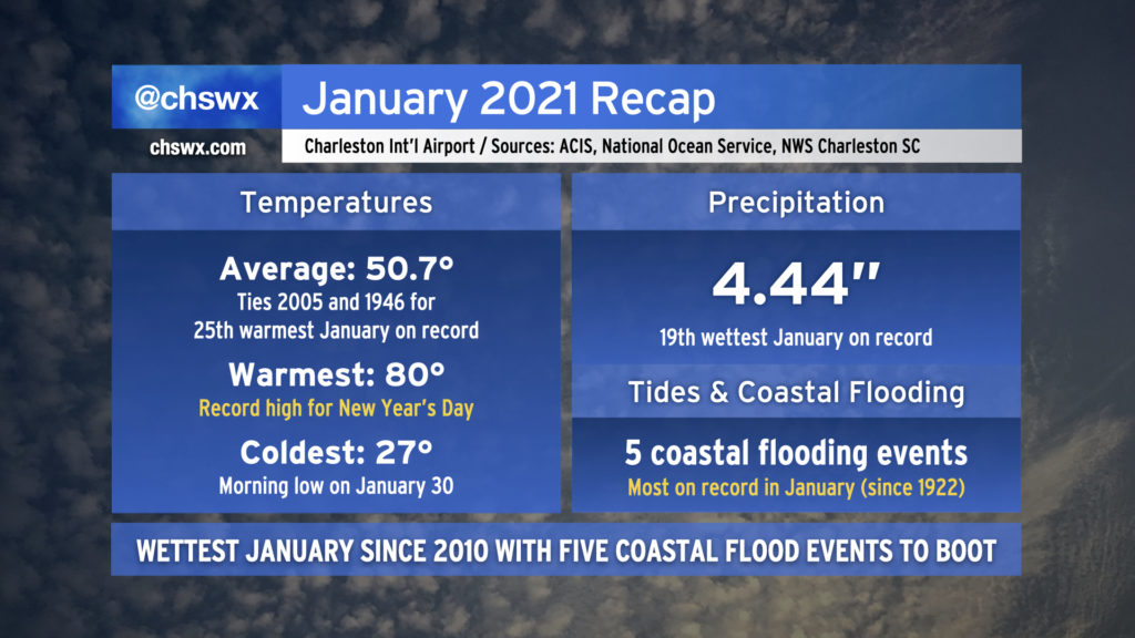
January 2021 has come to an end. It was an interesting month in many ways, but as far as weather goes, the month was on the warm and wet side of what passes for normal around here, but wasn’t too out of bounds.
Get your sweaters ready — Wednesday is going to be a chilly one. A dry cold front featuring a reinforcing shot of cold air will swing through the area tonight. By tomorrow morning, winds will be back out of the north and a little breezy — lows in the low 40s may feel closer to the mid-30s when factoring the wind in. Despite full sunshine, temperatures will only rise into the mid-50s given continued cold advection into the area.
As high pressure slips overhead Wednesday night, winds will calm and skies will remain clear, allowing for excellent radiational cooling conditions. We may be contending with some frost as we get into overnight Wednesday/early Thursday morning, especially in the inland tier of counties. Keep an ear out for a possible Frost Advisory from the National Weather Service, and be ready to ensure plants, pets, and people are protected. (Pipes will be okay — not expecting a freeze just yet.)
The calendar has turned to March, and with that comes the end of meteorological winter. Meteorological winter runs from the first of December to the end of February, and what a warm winter it was: With an average temperature of 54.8°, it was the fifth-warmest winter on record at Charleston International Airport since record-keeping began at that site in 1938. At Downtown Charleston (Waterfront Park), it was the ninth warmest winter on record, with an average temperature of 55.6°. (Records downtown started in 1893.)
Our stretch of very warm temperatures continues into Thursday, but changes in the pattern are afoot that will show winter reasserting itself especially as we get into next week.