A severe weather threat we will be awake for, at least

Our active severe weather season continues with another risk of damaging wind gusts and perhaps a tornado or two this afternoon into the evening hours. (At least we will be awake for this one — in 2020, you take the wins you can get.)
This morning’s weather situation

This morning is starting out cloudy and relatively quiet, with temperatures ranging from 68° on Johns Island to 59° at Moncks Corner. Winds are out of the east around 5-10 MPH in most locations, with a little breezier conditions at the coastal stations. These winds will stiffen as low pressure approaches the area this afternoon, with gusts to 40 MPH possible near the coast. Thus, the National Weather Service has hoisted a wind advisory starting at noon.
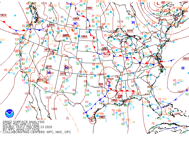
Overall, high pressure will continue to give way to the storm system currently moving through the mid-South. This storm system will lift a warm front through the area later today, placing the Lowcountry in the warm sector of the storm.
Overnight rainfall

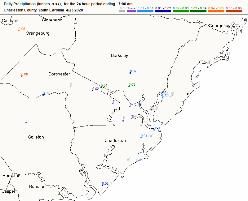
I measured a trace of rain in my gauge this morning from very light showers that came through overnight. Some CoCoRaHS stations were able to measure a few hundredths of an inch of rain from this activity, but amounts were light across the board. These showers have lifted northward this morning, and rain chances look to remain low — but not zero — into this afternoon.
Severe weather outlook

As the warm front approaches the area, winds will begin to pick up, especially near the coast, prompting the aforementioned Wind Advisory. At the same time, dewpoints will begin to head up into the upper 60s to around 70°, perhaps allowing some destabilization to occur, though cloud cover and even the risk of some rain showers will keep us from realizing the greatest severe risk. There is uncertainty about just how far north quality moisture and instability can get, which led to a downgrade to Slight Risk from the earlier Enhanced Risk across SC. Still, there will be the potential for a few storms to become severe, and so we need to watch it.
Storms will arrive in the area in perhaps one or two rounds. The first round should be most potent, while the second round will likely just be a rainmaker.
Round 1

The first round of storms will be the most potent for the Lowcountry. Thunderstorms — perhaps discrete supercells — will develop over Georgia by early afternoon and congeal into a squall line as the afternoon progresses. As modeled, this squall line looks to approach our neck of the woods starting in the 3-4 PM timeframe. The primary risk for severe weather in the Charleston metro will come from sporadic damaging wind gusts from 60-70 MPH. There will also be the risk of a tornado or two spinning up on the leading edge of the line.
It’s crucially important to note that if showers and storms break out ahead of peak heating, instability could be tamped down enough to preclude a more serious severe weather event. It’s also conceivable that thunderstorms to our south could rob the area of better-quality moisture and energy, too, weakening the northern extent of the line. Let’s root for this outcome, but be prepared for some heavy weather today.
Round 2

The second round of showers and thunderstorms will be associated with the cold front as it swings through the area overnight. Thankfully, it appears that the first round of convection will be vigorous enough to sap the energy out of the atmosphere, keeping these storms under severe limits. However, heavy rain and lightning will still be possible with these storms as they roll through.
Rainfall forecast
Another round of heavy rain appears likely for some of us with this storm system. The latest Weather Prediction Center precipitation outlook calls for 1-2″ with locally higher amounts across the area, with the greatest chance for 2″ of rain situated in the coastal corridor including the Charleston metro area. Given heavy rainfall from the Sunday-Monday storm system, this could cause some isolated pockets of flash flooding where the heaviest rain falls. Fortunately, it appears that the heaviest rain looks to fall closest to the 3PM low tide. As we well know, this does not eliminate the downtown flood threat, but it certainly does limit the time and severity of such a threat.
What to do today
- Make sure you have redundant, reliable ways to hear severe weather warnings. Test your NOAA Weather Radio; find your frequencies on the National Weather Service website. Most of us will want to tune in to station KHB29 at a frequency of 162.550 MHz.
- Know what you will do in case severe weather threatens your location and a tornado warning is issued. The best place to go is to an interior room on the lowest floor of a site-built structure, as far away from the outside as possible.
- When thunder roars, go indoors! All thunderstorms, whether they are classified severe or otherwise, are dangerous because of the lightning they produce.
- Remember the difference between a watch and a warning. A watch means conditions are favorable for the development of severe thunderstorms, and that you should stay on guard for adverse weather. A warning means they are happening and you should take action.
I’ll have updates as needed on Twitter and here throughout the day. Suspect there will be a live blog at some point as well for our Facebookers. Stay tuned.
Follow my Charleston Weather updates on Mastodon, Bluesky, Instagram, Facebook, or directly in a feed reader. Do you like what you see here? Please consider supporting my independent, hype-averse weather journalism and become a supporter on Patreon for a broader look at all things #chswx!

