It’s hurricane season again

It’s June 1, and that means that the Atlantic hurricane season has once again officially started. (Don’t tell Arthur and Bertha that they were early to the party.)
Through November 30, we’ll be keeping a weary eye on the Gulf of Mexico, Caribbean Sea, and Atlantic Ocean for possible tropical mischief. It could be a busy year for tracking storms, too. Let’s dig in.
Tropical outlook

Outlook forecasters at NOAA and Colorado State University both see a fairly busy hurricane season ahead in terms of the number of storms. NOAA is forecasting between 13-19 named storms, 6-10 of those becoming hurricanes, and of those, 3-6 becoming major hurricanes (category 3 or higher). As of its April 2 forecast (which will be revised on June 4), Colorado State is forecasting 16 named storms, eight of those becoming hurricanes, and four of those becoming major hurricanes.
So far in 2020, we already have two named storms under our belt: Arthur, which swept North Carolina as a tropical storm, and Bertha, which within a couple hours’ time spun up and made landfall between Isle of Palms and Bulls Bay last Wednesday.
What’s driving this potentially busy hurricane season? Blame warm water in the Atlantic and cooler-than-normal water in the Pacific aiding the relaxation of wind shear over the Atlantic:
The combination of several climate factors is driving the strong likelihood for above-normal activity in the Atlantic this year. El Nino Southern Oscillation (ENSO) conditions are expected to either remain neutral or to trend toward La Nina, meaning there will not be an El Nino present to suppress hurricane activity. Also, warmer-than-average sea surface temperatures in the tropical Atlantic Ocean and Caribbean Sea, coupled with reduced vertical wind shear, weaker tropical Atlantic trade winds, and an enhanced west African monsoon all increase the likelihood for an above-normal Atlantic hurricane season. Similar conditions have been producing more active seasons since the current high-activity era began in 1995.
NOAA seasonal outlook media release
Recent tropical systems affecting Charleston
Source: National Weather Service
Over the past few years, we have had quite a few brushes with significant tropical cyclones. Most recently, we took a strong side-swipe from Hurricane Dorian just last year, bringing excessive rainfall to areas northeast of the Cooper River, strong, damaging winds gusting to hurricane-force, and long-duration power outages. Matthew in 2016 probably remains the hardest hit in recent memory, though, bringing hurricane-force wind gusts, very heavy rain, and significant tidal flooding to the Charleston coastline. 2017’s Irma, despite making landfall hundreds of miles to the west in the Florida Panhandle, still brought significant rainfall, flooding, and tornadoes to Charleston. Even storms that don’t make landfall can have significant effects on our region, as evidenced by the 2015 flooding event. During this event, a moisture tap from Hurricane Joaquin, which was several hundred miles off the U.S. East Coast, combined with a strong upper-level system to drive record rainfall and historic flooding in the Carolinas.
One cannot have a discussion about hurricanes and Charleston without mentioning the city’s benchmark storm, Hurricane Hugo, which made landfall at Sullivan’s Island as a Category 4 storm 30 years ago this September, doing significant damage and setting records for storm surge and tides for the Charleston area. Hugo remains the worst tropical cyclone hit Charleston has taken in recent memory.
Managing storm anxiety
Hurricane season is a stressful period for many of you. It is important to balance the need to stay informed about potential tropical threats with the need for ensuring the maintenance of your mental health. Storm anxiety is absolutely a real thing — in fact, it birthed many meteorologists’ careers — and is nothing to be ashamed of.
Preparedness
The first, best way to combat storm anxiety is to get a lot of your preparations out of the way today. It’s amazing what you can get done well in advance of a storm that doesn’t expire — getting non-perishable food, building your disaster kit, learning the evacuation zone and routes for where you live, getting plans together for sheltering (that include your pets!) and much more.
In light of the coronavirus pandemic affecting us here at home and around the world, it’s more important than ever to get prepared now if at all possible. Getting prepared under the specter of a looming tropical cyclone is stressful enough — now add social distancing protocols on top of that. (Yikes.)
My advice in this scenario: If at all possible, be strategic about it and add a few non-perishable supplies to one grocery run a week. This will let you get started on your disaster kit gradually, makes it easier to budget for, and (hopefully) will allow flexibility given current supply constraints for certain items (*cough*TP*cough).
Another tip that I absolutely love comes from my colleague Sarah Watson at S.C. Sea Grant: Have an Amazon wishlist of important and perhaps a little more perishable hurricane supplies ready to go. When a storm threatens, just order the wishlist and have it delivered. It will keep you out of crowds and allow you to both prepare for the storm while reducing your risk of exposure to coronavirus.
Getting information from reliable sources

The volume of storm information on social media is astonishing if not downright overwhelming. There are so many different ways to consume storm information now, and that is great. While some convey a calm, impacts-based message (as recommended by the Weather-Ready Nation Ambassadors), others — knowingly or otherwise — may share information that is not necessarily grounded in reality or, at worst, is designed for emotional manipulation for profit. (It’s out there.)
Make sure the sources you get weather information from are reliable and grounded in reality. These sources will prefer National Hurricane Center forecasts to speculation, only raise the alarm when it is warranted, and will carefully explain forecast reasoning as opposed to lots of hype-charged rhetoric. Be especially wary of weather sources that over-sell the need to like and share posts, or worse, pump you for money at every opportunity. (Yes, I have a Patreon, but I am very careful — to my detriment, probably — not to shove it in everyone’s face.)
How @chswx covers storms
In the spirit of full transparency, I think it’s important to discuss some of the editorial decisions I make here. I cover weather events a little differently than a lot of outlets because I have constraints — and freedoms — that other outlets do not. Here’s how I handle hurricanes:
- Give storms the proportion they deserve. If it’s a random swirl in the Atlantic, I mention it once, acknowledge it exists, and then move on. It’s summer in Charleston — there’s always other weather to discuss. No need to clog your timeline with largely irrelevant storms. This way, if I’m talking about a storm on a regular basis, it’s a good signal to keep up with it.
- I share only official National Hurricane Center forecasts publicly. It does a disservice to muddy the waters with model data that may or may not pan out. Models are guidance, not gospel, and the Hurricane Center is really, really good at forecasting storm tracks. I’m going to let them do what they do best. Computers are getting better, but humans continue to reign supreme.
- I do my best to write with empathy and respect for my readers. My posts are not written with the express intent of inflaming storm anxiety. If they do, hold me accountable.
Reach out (seriously!)
If you are experiencing storm anxiety, my Twitter DMs are open, or send me a message. As a sufferer of storm anxiety myself — I actually really hate hurricane season — I’m happy to help you weather it.
Off to a busy start
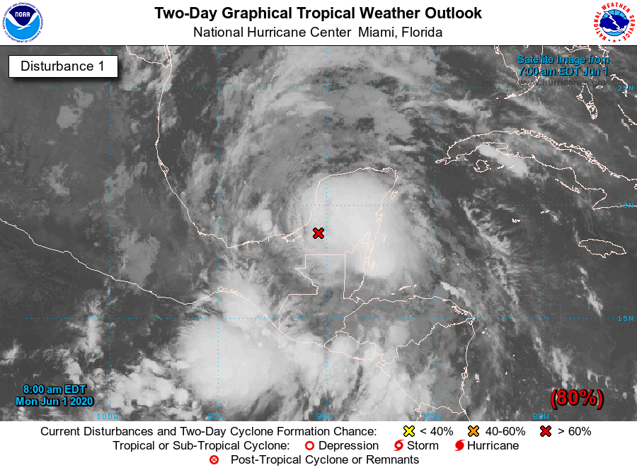
The Atlantic hurricane season has gotten off to a busy start. For the second time in five years, we begin June 1 with the “A” and “B” named storms already off the list. The “C” storm, Cristobal, appears to be a possibility in the Gulf by the end of this week. NHC is monitoring an area of disturbed weather — the remnants of Tropical Storm Amanda in the pacific — that looks to re-emerge into the Bay of Campeche and will likely develop into a tropical cyclone. Said theoretical tropical cyclone may bring heavy rainfall to Texas and Louisiana’s Gulf Coasts early next week.
Otherwise, there are no current tropical threats to South Carolina. I’d like to keep it that way, but we all know Mother Nature often has other plans. Let’s get ready for more storms to come, and hope that Bertha was our one-and-done.
Follow my Charleston Weather updates on Mastodon, Bluesky, Instagram, Facebook, or directly in a feed reader. Do you like what you see here? Please consider supporting my independent, hype-averse weather journalism and become a supporter on Patreon for a broader look at all things #chswx!