Tropical update: Watching Potential Tropical Cyclone Nine

Potential Tropical Cyclone Nine — which may become Tropical Storm Isaias later today — continues to churn into the Caribbean this morning. Its satellite presentation has improved over the last couple days, and is beginning to show signs that it might be finally getting its act together enough to become a tropical cyclone. It’s bringing heavy rain to the Leeward Islands and will spread its effects into Puerto Rico later today.
Where’s it going?
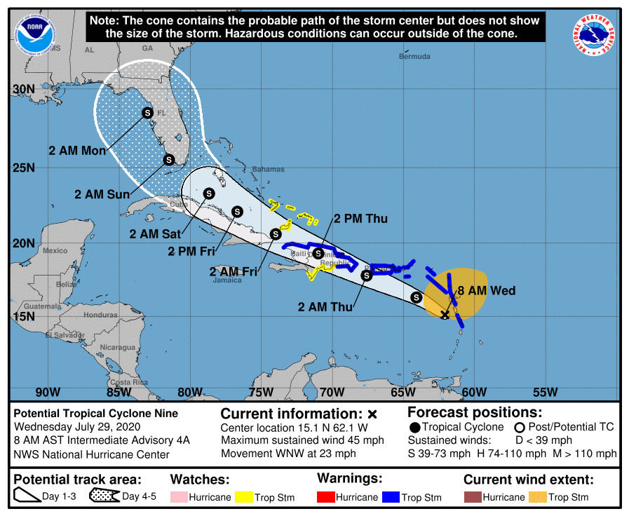
The 5am track from the National Hurricane Center brings PTC 9 — future Isaias — up through the rugged terrain of Hispaniola tomorrow, near Cuba and into the Bahamas by Friday, and Florida by the weekend. I would be very cautious with the track forecast beyond Friday at this point, though — since the storm has yet to fully develop, the models are really struggling with where to initialize the center. Indeed, we’ve already seen some fairly decent initialization error with the storm already, including last night when the position was well south and west of the NHC forecast.
A hostile road ahead

PTC 9 is going to run into quite a few obstacles during its westward trek over the next few days:
- Plentiful wind shear, which is very unfavorable for tropical cyclone development as it will tear the core of the storm apart
- The mountainous terrain of Hispaniola and possibly Cuba
- Residual dry air ahead of the storm
This is a big reason why the current intensity forecast does not go beyond tropical storm strength, especially if the storm maintains a more southerly track. The caveats with track, though, also apply to intensity (which is harder to predict in general) — a northerly course past Hispaniola could spare it the brunt of the wind shear, and perhaps allow for some intensification.
So what about Charleston?
Well, the answer to that question is the one I absolutely hate to give but the science demands that I do: It’s just too soon to tell.
Bottom line here is that while we can generally surmise that it is going to go west and eventually recurve northward, it is hard to say:
- How strong it will be (or if it even survives land interaction and wind shear)
- Where it will recurve
- How far south and west it will go before it recurves — a weaker storm will go more west
All of these variables play into what, if any, impacts we see from this storm. If we were to see anything from it, it’d probably be Monday or Tuesday before we do.
So, we will continue to watch and wait. Once the storm’s center forms and we can get some more Hurricane Hunter data in, that should help start to stabilize the models and get us a better look at what’s happening. Additionally, with Florida NWS offices releasing additional weather balloons every six hours (as opposed to every twelve), we’ll get more frequent upper-air samples as well, which in turn should further assist the models with additional data around the strength of the ridge which will help turn the storm northward.
No time like the present to prepare
Even if PTC 9/future Isaias does not have any material impact on our weather, it’s never too early to get a few hurricane preparations done ahead of time so that you can relieve at least a little stress when a storm does threaten. This is especially important in a time when we are all dealing with a global pandemic. The South Carolina Emergency Management Division has some excellent tips on ways you can get ready well before a storm hits — check them out.
Follow my Charleston Weather updates on Mastodon, Bluesky, Instagram, Facebook, or directly in a feed reader. Do you like what you see here? Please consider supporting my independent, hype-averse weather journalism and become a supporter on Patreon for a broader look at all things #chswx!