Isaias @ 11am: Tropical storm force wind probabilities increase

The 11am advisory from the National Hurricane Center tweaked the forecast track for Isaias a little westward and faster. Maximum sustained winds remained around 70 MPH despite some signs of dry air intrusion. It is forecast to make landfall as a Category 1 hurricane somewhere around Georgetown or the Grand Strand.
The westward shift has some small implications for wind and tide forecasts for this evening. Overall expectations for impacts remain on track, though.
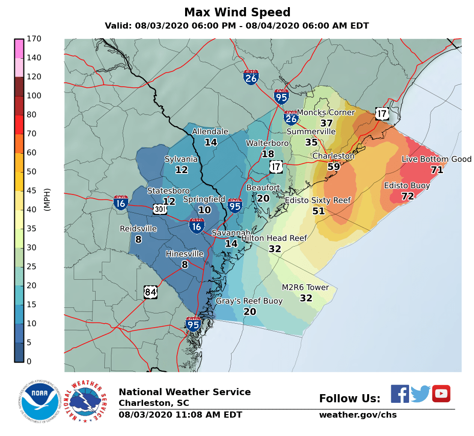
Tropical storm force winds more likely in the metro area

The westward shift in track at 11am was subtle, but will do a couple things if it verifies:
- Shifts the point of a potential landfall closer to the Grand Strand/Georgetown areas.
- Spreads tropical storm-force winds and gusts a little further inland, including the potential for sustained tropical storm winds in parts of the Charleston metro area
- Raises a small risk of hurricane-force gusts at the coast
Timing for the strongest winds in the metro area appears to be between 5 and 8 PM based on the latest gridded forecast from the National Weather Service.
While another wobble back east is not out of the question at all, we will need to monitor this potential for stronger winds in the metro area, producing power outages and tree damage.
Worst-case tide scenario appears unlikely, but flooding remains probable downtown
Isaias’s faster forward motion will significantly reduce the likelihood that peak storm surge will combine with high tide. The center looks to travel north of our latitude by 7PM or so, which will subsequently shift winds around to the north and northwest. This is very good news for avoiding an absolute worst-case flooding scenario. However, heavy rainfall ahead of an increasing tide will still likely produce flooding in downtown Charleston this afternoon and evening, which may prove to still be significant. Flood precautions should be just about complete as heavier rain looms off the coast, looking to begin to have impacts closer to 3-4 PM.
More here as needed throughout the evening!
Follow my Charleston Weather updates on Mastodon, Bluesky, Instagram, Facebook, or directly in a feed reader. Do you like what you see here? Please consider supporting my independent, hype-averse weather journalism and become a supporter on Patreon for a broader look at all things #chswx!