Friday and the weekend: Exit humidity, enter tidal flooding
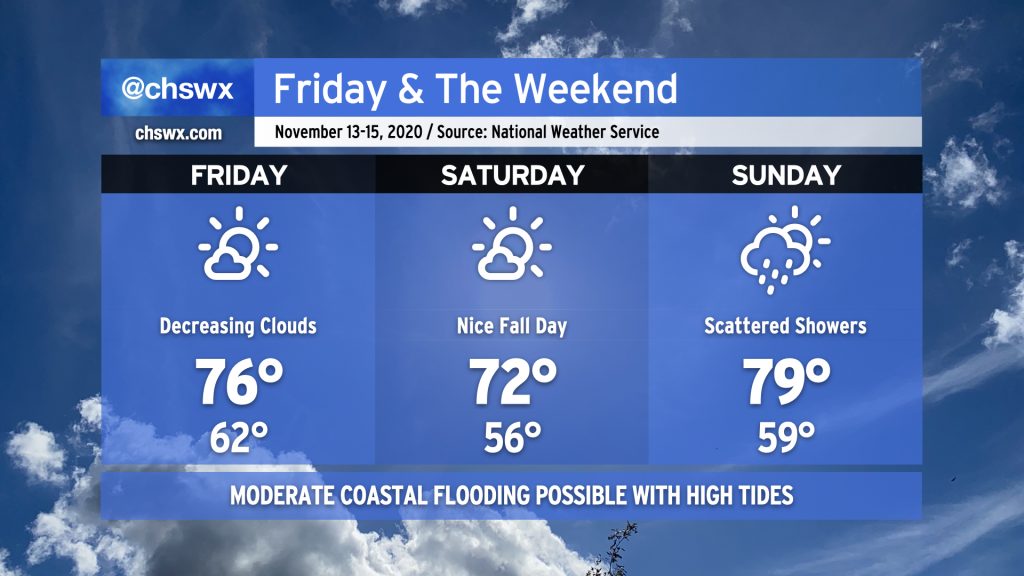
After a soggy day that turned quite breezy thanks to Tropical Storm Eta and a cold front, we will begin to see temperatures more in line with what we expect from Fall (but still above normal). Clouds will scour out on Friday, leaving a fairly lovely day with highs topping out in the mid-70s. Saturday will be quite refreshing in comparison to where we have been; we’ll start the day in the mid-50s and head up to around 72° under mostly sunny skies. A cold front approaches the area on Sunday, which will kick up a little compressional heating ahead of it and send highs back toward 80° (albeit with less humidity). A few showers will be possible ahead of the front. Sunday’s front is the one that is going to knock us back into temperatures more in line with November norms as we get into next week.
Coastal flooding at times of high tide this weekend, with moderate flooding at times

Northeasterly winds and this weekend’s new moon will combine to produce very high tides starting early Friday morning. Moderate flooding will be possible during the morning high tides this weekend, which will likely close some roads in downtown Charleston for a few hours at a time. Thankfully, a major deluge is not forecast for this king tide period, and so we aren’t expecting much beyond sunny day flooding. However, these tides will still cause problems.
The National Weather Service has already issued the first of what will likely be a series of Coastal Flood Advisories for Friday morning between 4-8am. The tide is forecast to top out between 7.6-7.8′ a little before 6am. At these heights, we see significant flooding develop at Hagood and Fishburne, at the City Market, Lockwood Drive, and along the Highway 61 off-ramp from Highway 17 heading into West Ashley. Be ready to use alternate routes if you commute a little early tomorrow.
Flooding will also be possible, but not quite as severe, during the evening high tides as well. Still, vulnerable roads will run into problems during these periods as well.
Fall is coming back
Once the front gets through Sunday and Monday, we will begin to see Fall return to the Lowcountry to start Tuesday. Expect lows in the mid-40s and highs in the mid-60s for much of next week — much more in line with what we expect in November.
Follow my Charleston Weather updates on Mastodon, Bluesky, Instagram, Facebook, or directly in a feed reader. Do you like what you see here? Please consider supporting my independent, hype-averse weather journalism and become a supporter on Patreon for a broader look at all things #chswx!