2021 to get off to a stormy start
We’re going to get 2021 off to a bit of a stormy start as a cold front affects our weather Friday and into much of the weekend before clearing the area Sunday afternoon.
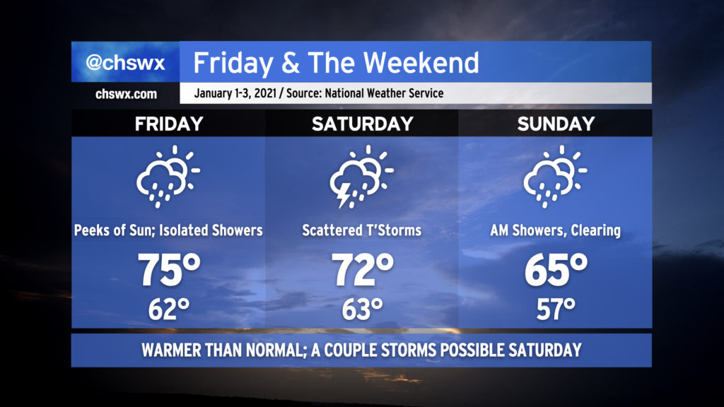
Friday: Isolated showers and perhaps a few peeks of sun
New Year’s Day is going to feel quite springlike as highs top out in the mid-70s in the afternoon. A shower or two cannot be ruled out, but many of us will stay dry until the evening hours when a weakening line of storms approaches the area ahead of a stalling cold front. The slower progression of the front blunts some of the severe weather risk for the Charleston Metro Area, but there is still a marginal risk for a severe storm or two from roughly I-95 west in the late afternoon/early evening hours.
Saturday: Cold front makes its move
The cold front will strengthen and resume its eastward progression during the day Saturday. We’ll want to keep an eye out for scattered showers and thunderstorms during what will be another warm day with highs in the low 70s. Saturday afternoon and evening, we will want to monitor for some heavier rainfall advancing on the area from the southwest as another warm front lifts north of the area. Some spots may see an inch of rain or more. Instability looks meager, but there will be the potential for a couple storms to produce damaging wind gusts given ample wind shear. Storms could also rotate with the warm frontal passage, so we’ll want to watch this.
Even outside of thunderstorms, winds look to turn gusty during Saturday evening into early morning, particularly if a low-level jet depicted in the high-resolution models verifies. Raw model output has shown a potential for gusts 30-40 MPH, so there could be some residual issues with decorations, particularly those inflatables. (Consider using the dry slot
Sunday: Cold front passes, skies clear and we cool off
A line of showers and perhaps a thunderstorm will move through the area ahead of the cold front early Sunday morning. Once the front finally gets offshore, winds will shift around to the west and we will start to see skies clear out. If timings work out, we could get a few really pleasant afternoon hours in with a bit of a breeze from the west as high pressure builds into the area. Expect temperatures to top out generally in the mid-60s with cooler and drier air moving in throughout the day.
Looking beyond
The first work week of 2021 looks rather quiet. NWS is forecasting temperatures generally around, if not a touch above, normal for early January with mostly sunny skies through Wednesday.
On a personal note: Happy new year! My best to all of you for a wonderful 2021. (I know the bar isn’t terribly high for this, but still.) I want to especially thank my Patreon supporters for their generosity, which helps keep the servers running and the data flowing throughout the year. One nice side effect of eliminating two hours of commuting a day is that I’ve been able to give the website side of things much more love than I’ve been able to in the past. Expect more investments in chswx.com as 2021 evolves — there are some really exciting and tangible things in the works and I think you will like them!
Follow my Charleston Weather updates on Mastodon, Bluesky, Instagram, Facebook, or directly in a feed reader. Do you like what you see here? Please consider supporting my independent, hype-averse weather journalism and become a supporter on Patreon for a broader look at all things #chswx!