Wettest January since 2010 comes to a close
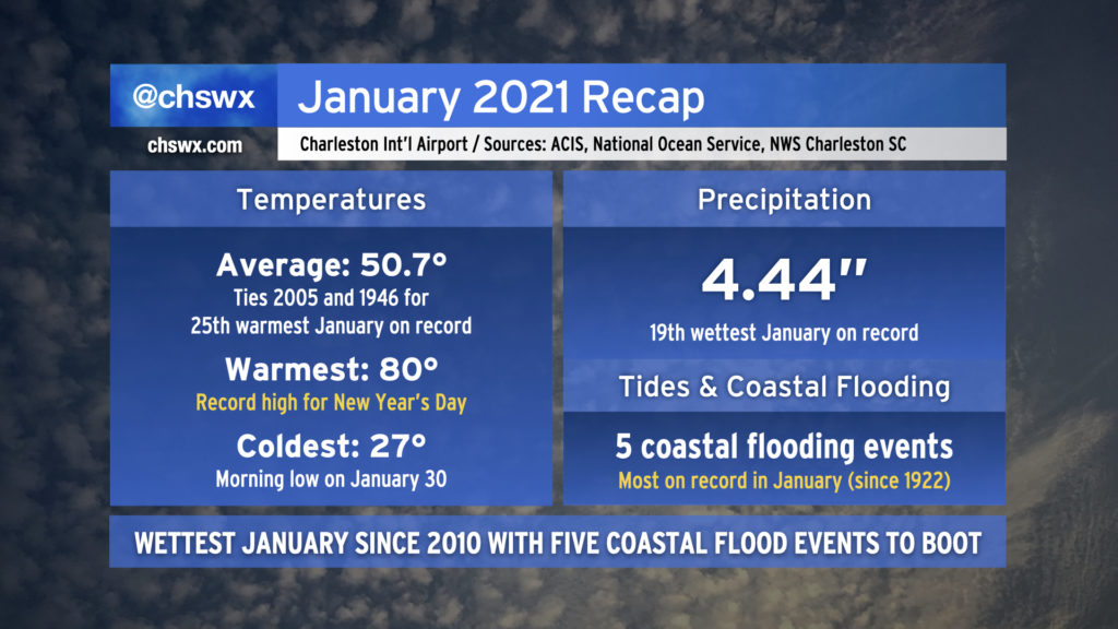
January 2021 has come to an end. It was an interesting month in many ways, but as far as weather goes, the month was on the warm and wet side of what passes for normal around here, but wasn’t too out of bounds.
Precipitation
January 2021 was the wettest January in 11 years with 4.44″ at the North Charleston climate site, culminating with 1.12″ on Sunday, a daily record for January 31.
Overall, 4.44″ is good for 19th wettest January on record, and the wettest since 6.46″ was recorded back in 2010. January of 1993 remains the wettest on record, with 8.93″ that month.
Precipitation records at the North Charleston climate site for January date back to 1939.
Temperatures
We had our usual spate of cool-season storms in January — some of which would bring us to the 60s and 70s for a couple days, followed by cool high pressure. Temperatures didn’t get terribly cold for any particular stretch this month, either. Overall, the average temperature for the month was 50.7°, with the average high at 60.5° and the average low at 40.9°. All of these values are a smidge under the five-year moving average.
The warmest day of the month was the first day of the month! We set a record high of 80° on New Year’s Day (remember that?) with an average temperature of 70°, nearly 22° above the normal average for January 1. The coldest temperature we felt was 27° just this past Saturday, January 30.
The warmest January on record remains January 1974, with an average temperature of 61.8°, and the coolest remains January 1940, with an average temperature of 37.7°.
Temperature records at the North Charleston climate site for January date back to 1939.
Coastal flooding
Charleston Harbor recorded five minor coastal flooding events in January 2021, the most of any January on record dating back to 1922 according to the National Weather Service Coastal Flood Event Database. The highest tide was 7.05′, which occurred both on January 12 and January 30. Several times, tides came just shy of the 7′ threshold as well, which has been known to still cause some minor pooling of salt water on the most vulnerable roads near Charleston’s hospital district.
This is the seventh consecutive year of at least one coastal flood event in downtown Charleston in January, and the most since 4 events were recorded in 2016 (the previous high).
For the year, we have five minor coastal flooding events and no moderate to major events. Climatologically, coastal flooding peaks in the fall months due to the prevalence of tropical cyclones and the increasing effects of coastal storms.
Notable event: The January 26th hailstorm
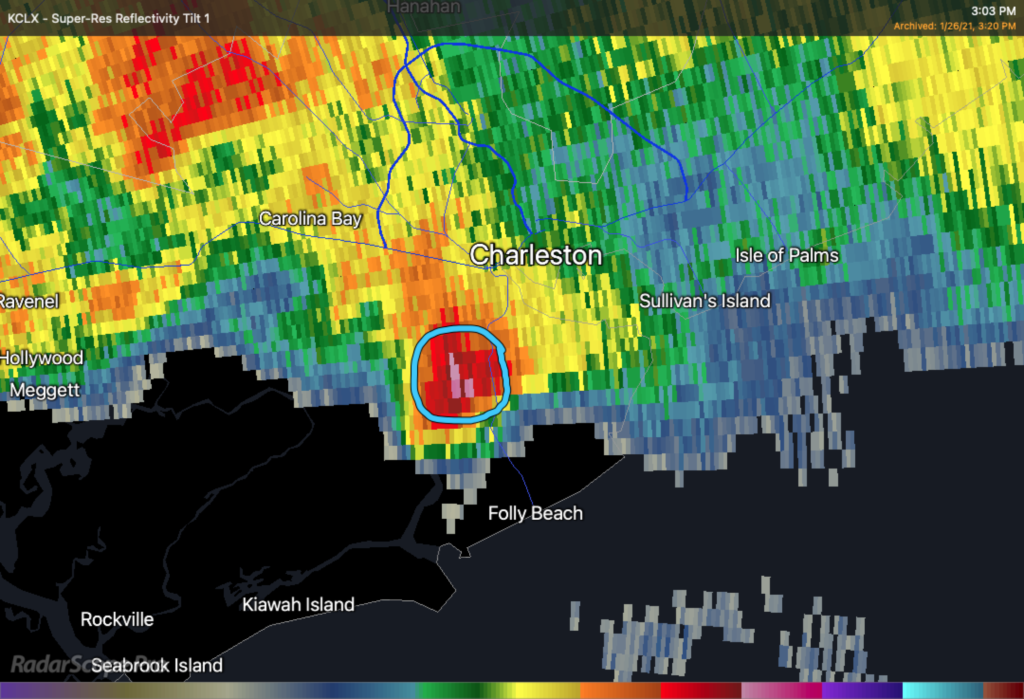
On the afternoon of January 26, a thunderstorm moving along a boundary was able to tap into sufficient instability to generate up to nickel-sized hail as it traversed Johns and James Islands. This storm was fortunately short-lived, but dropped hail across at least an 8-mile path (and likely continued to do so as it entered the harbor).
No damage was reported (except to various psyches). And, alas, this was the only frozen precipitation we recorded in January. (Sorry, snow lovers.)
Follow my Charleston Weather updates on Mastodon, Bluesky, Instagram, Facebook, or directly in a feed reader. Do you like what you see here? Please consider supporting my independent, hype-averse weather journalism and become a supporter on Patreon for a broader look at all things #chswx!