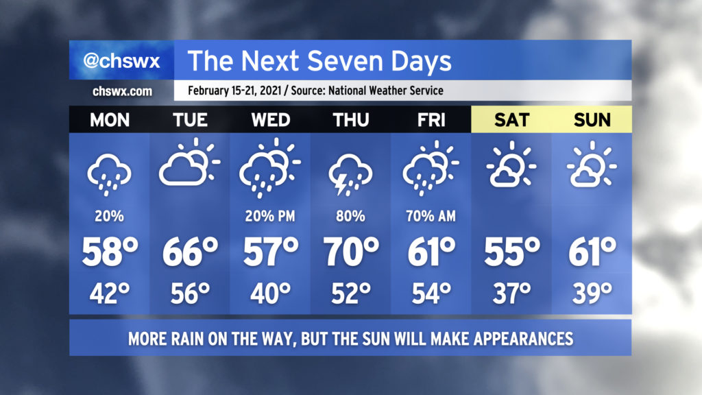
The week ahead: Unsettled weather persists, but the sun will shine again
It’s been quite a soggy weekend, with rain totals in many spots exceeding 1″ just today as seemingly relentless moisture pushed atop a cold air damming wedge, keeping the weather wet and chilly as temperatures have barely left the low 40s over the past two days.
Well, the good news is that things are changing, and that we will even see the sun at times this week! (The weekend looks good, too!) But, there will be more unsettled weather before it’s all said and done.
Tricky forecast for Monday as the wedge lifts out
Monday’s going to be kind of a weird weather day. In the morning, the high pressure wedge which has kept us nasty and cold this past weekend will continue to be in place, keeping drizzle and the occasional shower or two in the forecast. As the day goes on, the wedge should gradually begin to erode, allowing temperatures to reach the low 50s in the afternoon primarily near the coast and in southern parts of the Tri-County. Still, though, many spots may struggle to get out of the 40s west of 17-A.
Monday’s highs will be set after dark
After sunset, we’ll be watching the progress of a warm front as it lifts northward ahead of another storm system projected by the vast majority of guidance to be reaching the Alabama/Georgia line by 7PM. Models are generally in agreement that the warm front will be lifting north of our neck of the woods by then, and as a result, we will achieve our warmest temperatures of the day after sunset, with temperatures in the 60s becoming commonplace across the region by midnight.
Possible overnight severe weather risk
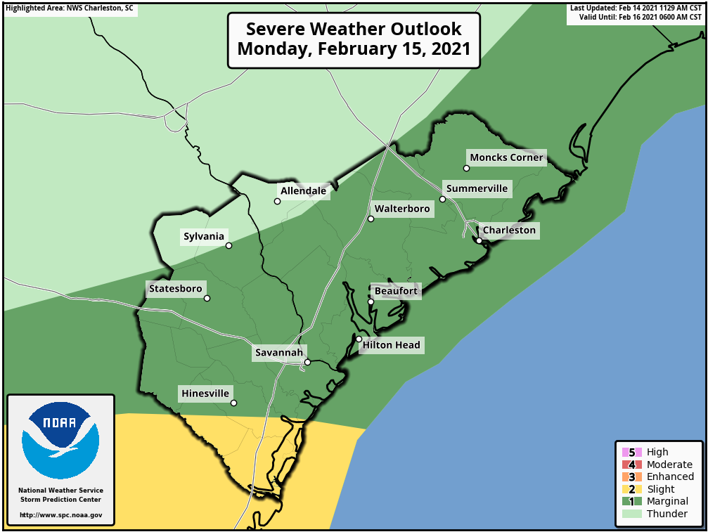
As the warm, moist airmass overtakes the area, we’ll also see a strong low-level jet develop and head northeast across the Carolinas, helping to enhance wind shear especially in the lower levels. This, combined with some instability developing generally along and east of I-95, could help fuel a few strong thunderstorms overnight Monday into early Tuesday morning. Model soundings suggest a shallow stable layer near the surface will help to temper the severe risk some, but if storms can disrupt this stable layer and can mix air to the surface, there will be a window of a few hours (generally 10PM-3AM) where a severe thunderstorm with damaging wind gusts will be possible. As we get more into Tuesday morning, the environment will gradually become more stable ahead of what should be a decaying squall line by the time it reaches us, diminishing the severe weather threat.
This is far from a slam dunk, but the Storm Prediction Center does have us in a marginal risk for severe storms for tomorrow night for that reason. We will watch this carefully Monday to see how model trends evolve. In the meantime, it’s not a horrible idea to make sure your weather radio is tuned properly.
Sun returns Tuesday, but clouds fill back in Wednesday
A cold front will swing through the area early Tuesday morning, shutting off the rain for a little bit and allowing some drier air (finally!) to fill into the area. Cloud cover will decrease and we will likely see the sun for the first time in several days! Sunshine and westerly winds will allow temperatures to rise into the mid-60s Tuesday afternoon.
The sunshine will be short-lived, though, as clouds fill back in on Wednesday as a coastal trough develops. Highs on Wednesday will top out in the upper 50s with a weak high pressure wedge pattern and the increasing cloud cover. By Wednesday evening, a few showers will be possible as the trough moves inland.
Next cold front arrives early Thursday into Friday, yielding a nice weekend
Another cold front, driven by a digging trough of low pressure aloft, will swing through the area Thursday into Friday. Thursday is pegged to be the warmest day of the week (and perhaps the warmest day of February so far with a forecast high of 70°) as warm air lifts northward ahead of the front. Some weak instability may develop, and a few thunderstorms will be possible Thursday afternoon as a result. The front looks to sweep through the area by Friday morning. From there, high pressure builds in and we look to have a fairly nice weekend with temperatures at or a little below normal and much more sun than we have become accustomed to!
Follow my Charleston Weather updates on Mastodon, Bluesky, Instagram, Facebook, or directly in a feed reader. Do you like what you see here? Please consider supporting my independent, hype-averse weather journalism and become a supporter on Patreon for a broader look at all things #chswx!