Chilly rain, an all-too-familiar sight, back with us on Tuesday
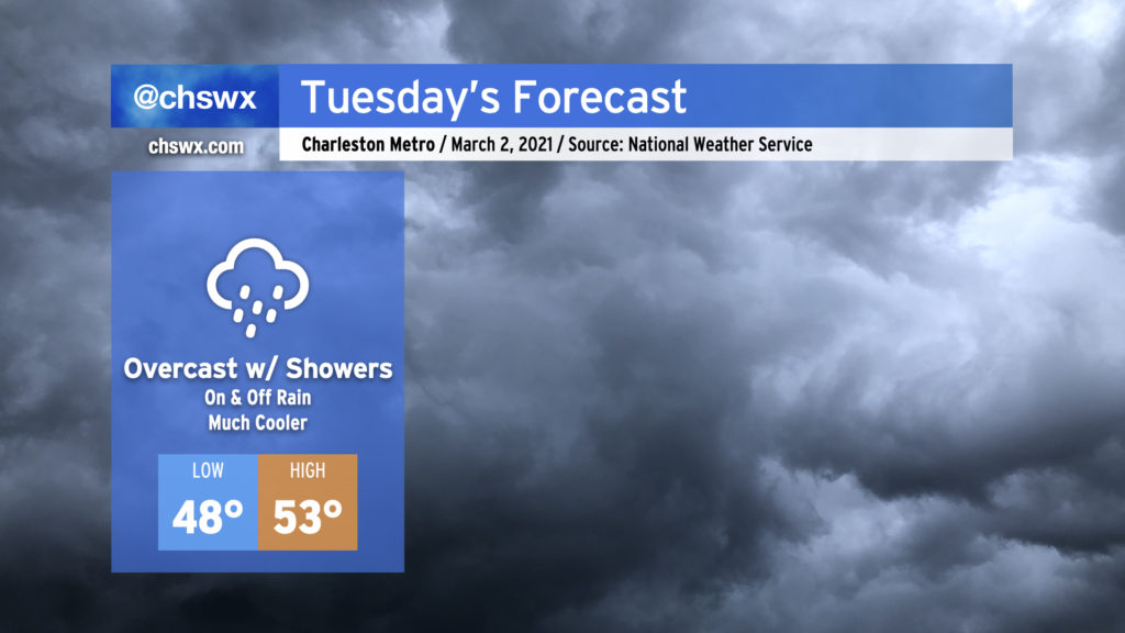
Stop me if you’ve heard this one before: We’re looking at a mostly cloudy day with occasional showers for Tuesday. Alas, March throws it back to mid-February tomorrow as temperatures only top out in the low 50s in the afternoon as cold air damming develops in the wake of this evening’s frontal passage. It won’t rain all day, but you’ll want to keep the gear close by in case you find yourselves in some showers. We’ll stay in the muck through Wednesday, with clearing developing on Thursday, but temperatures will remain well below normal for the rest of the week.
A look at February’s weather through graphs and charts
Qualitatively and quantitatively, it’s safe to say that February 2021 was a dreary, wet, and chilly month with lots of overcast and quite a bit of rain. Let’s dive into the numbers.
Chilly, but fairly average, temperatures
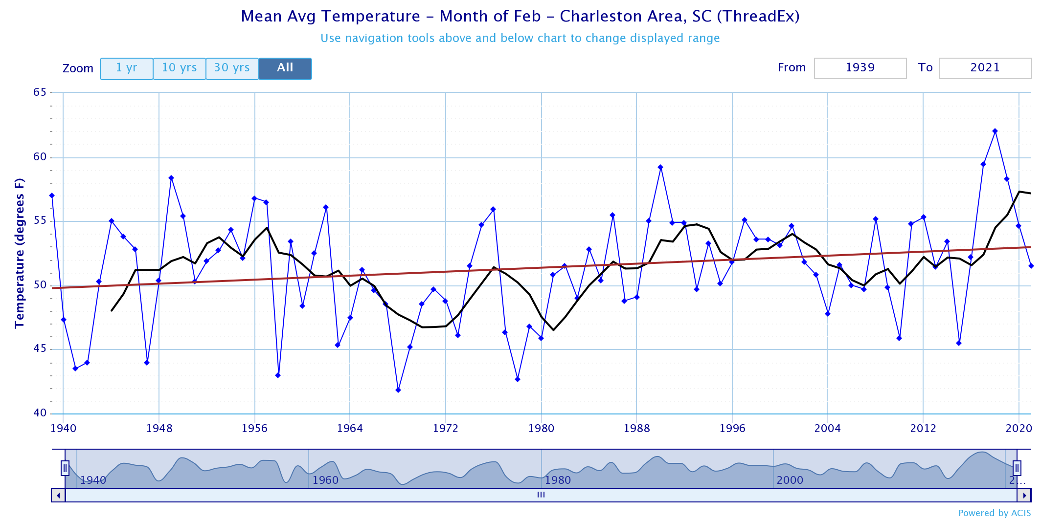
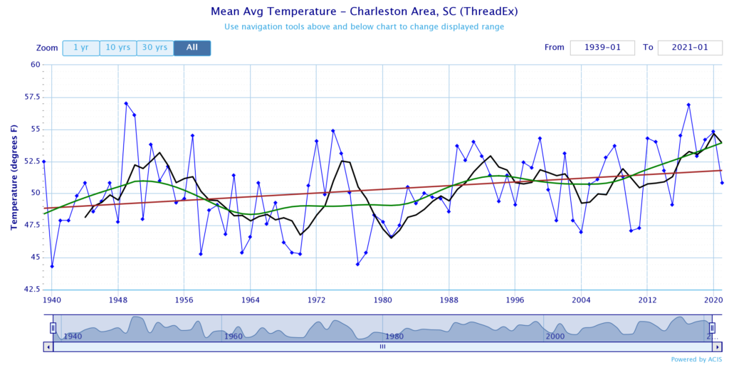
The average temperature at the North Charleston climate site (the airport) was 51.5°. This is the coolest February we’ve had in several years, but was still nowhere near as cold as 2015 — the year “polar vortex” entered the mainstream lexicon, for better or worse. Historically speaking, this past month fell in the middle of the pack. February 2021 ties 1982 and 1974 for 40th warmest — and 42nd coolest — February on record. (Of course, this result was likely driven upwards by a couple afternoons in the 80s to close things out.)
Quite a bit of rain in a climatologically dry month
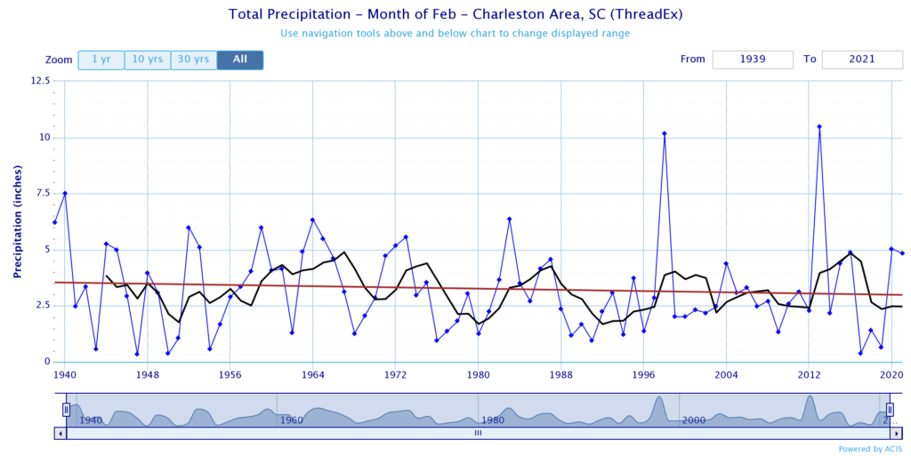
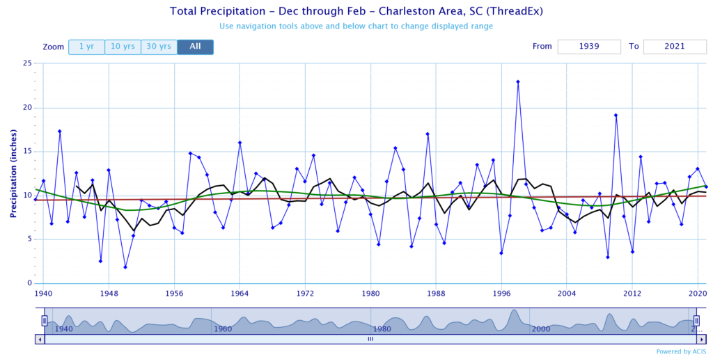
Precipitation-wise, this was certainly a wetter-than-average February, which is usually one of our drier months. 4.83″ at the airport is good for 18th wettest February on record, and runs well above a somewhat wildly-swinging five-year moving average. A normal February sees about 2.96″ of rain.
Clouds everywhere
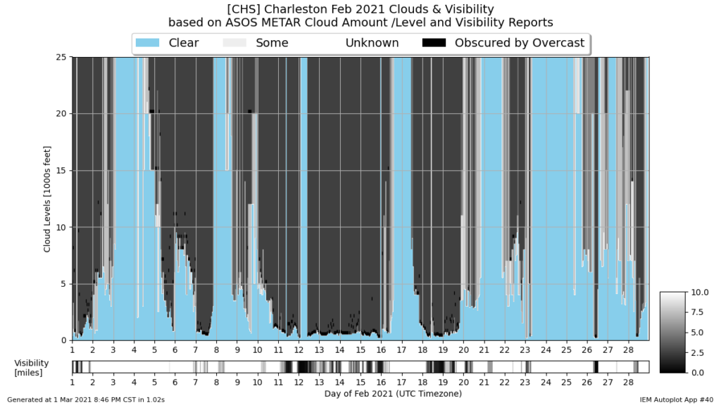
If there’s one thing most of us will remember (or choose to forget) about this February, though, it was the lack of sunshine. The plot above, generated at the Iowa Environmental Mesonet from airport weather observations, does a nice job of detailing just how cloudy it has been, with precious few days with a sky unobscured by overcast. (That stretch from the 12th to the 16th…ugh!)
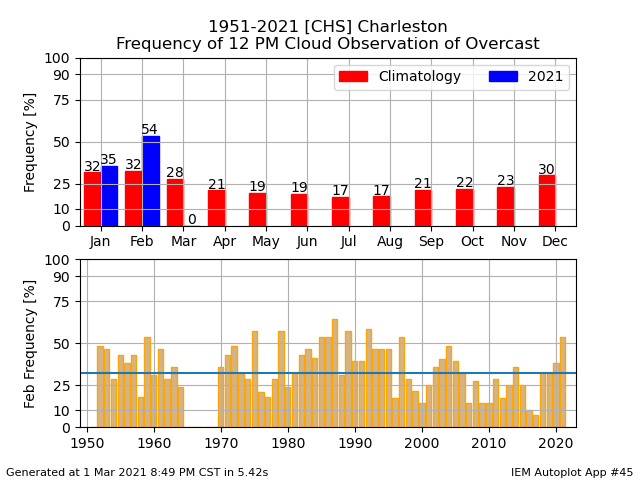
Another way to look at just how much overcast we had uses another plot from the Iowa Mesonet, which examines a specific hour and looks for the “overcast” code in the observation (OVC for those of you who speak METAR). The number for noon this past month is pretty astonishing — 54% of the time, overcast was reported at the airport. Historically (with the caveat that about five years of data is missing), we’d see overcast at noon around 32% of the time in February.
Silver linings: No coastal flood events
For the first time since March of 2020, we’ve gone a month without a coastal flood event. February is traditionally not a month that features many coastal flood events to begin with, but after a record five events in January, it’s nice to put the salt water flooding aside for a little bit. This is particularly remarkable considering the cold air damming scenarios we found ourselves in; northeast winds in those scenarios can often drive water levels up. Seasonally, though, the beginning of the year is typically an inactive period.
As always, you can get lots of valuable information about coastal flood events in the Lowcountry at the National Weather Service’s Coastal Flood Database, which was recently expanded to include events dating back all the way to 1922 — almost a century’s worth of data!
A rather unremarkable meteorological winter comes to a close
The meteorological winter of 2020-2021 will come to a close with average temperatures tying 1943-1944, 1946-1947, and 1964-1965 for 34th warmest winter on record. This is right in the middle of the pack when taking all the records as a whole — nothing terribly hot, but nothing terribly cold either. The airport only recorded 17 days with temperatures at or below freezing, while only 19 days met or exceeded 70°.
The moderate temperatures we experienced this winter have been more rare than not — it’s either pretty frigid (see 2010, 2011) or blowtorch warm (see 2016-2017), with the in-between being somewhat rare air. Overall, the trend is toward warmer winters, following the overall global climate trend.
Precipitation, too, was close to the middle of the pack: 10.99″ for the season puts the winter of 2020-2021 at 33rd wettest since records began in 1938. Year-over-year, this winter was a little drier, but we do see a subtle upward trend overall toward wetter winters.
Finally, in true Charleston fashion, all but a trace of our recorded precipitation this winter came in liquid form. The exception was a brief burst of flurries on Christmas morning, only the second time on record where a trace or more of snow fell on Christmas Day (the other was 1998). Given some of the overrunning setups we had in February, it is somewhat miraculous we did not deal with ice this far south. Got lucky on that one.
On that note, bring on spring. (Let’s just try not to repeat the tornado problems we had last year, shall we?)
Follow my Charleston Weather updates on Mastodon, Bluesky, Instagram, Facebook, or directly in a feed reader. Do you like what you see here? Please consider supporting my independent, hype-averse weather journalism and become a supporter on Patreon for a broader look at all things #chswx!