The week ahead: All aboard the temperature rollercoaster
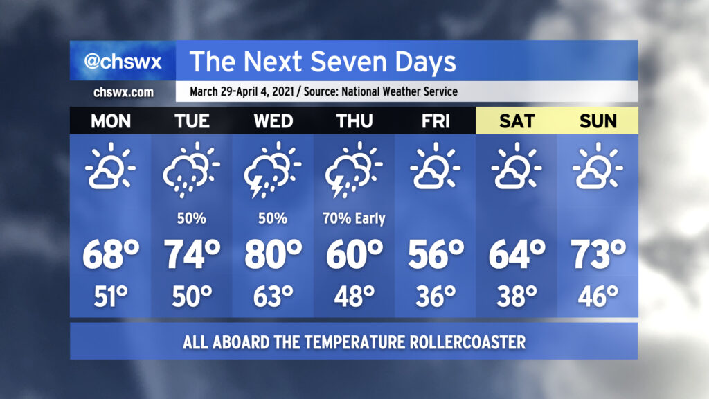
Spring, being a transitional season, will often give you its share of weather whiplash. This is going to be one of those weeks where your jacket and shorts should stay within equal reach.
We start the week with high pressure asserting control over our weather, albeit briefly. It’ll be much cooler — we’ll start Monday in the low 50s. Late-March sunshine will be enough to push temperatures into the upper 60s, but that is still a little cooler than normal for this time of year. Temperatures moderate a bit on Tuesday as high pressure slips offshore, but we’ll also see shower chances return to the picture as well.
Our best thunderstorm chances this week come Wednesday into early Thursday as a warm front lifts north across the area followed by a strong cold front. We could warm to around 80° on Wednesday post-warm frontal passage before the mercury comes crashing back down to earth for Thursday, when temperatures will struggle to 60°. Frost and freeze issues could very well come into play Friday morning as temperatures dip to the mid-30s in the immediate Charleston Metro Area with colder temperatures, perhaps flirting with freezing, further inland. The high on Friday should only top out in the mid-50s despite ample sunshine, owing to the abnormally chilly airmass working its way into the area to help get April started out on a chilly note. The early April sun angle will help modify this airmass, though, with temperatures warming back to around normal by Sunday. It’ll be a nice weekend to get outside with plenty of sunshine and comfortable humidity levels expected.