Storms to increase this evening with a localized flooding threat
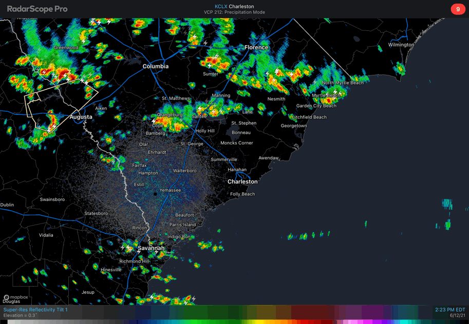
We in #chswx continue to watch for the potential for heavy rain with thunderstorms later this afternoon into tonight. Radar at 3PM begins to show some showers and storms sinking into the northern part of the Tri-County, including St. George and the Lake Moultrie region. Further north, we see a line of intensifying thunderstorms stretching from Horry County through Sumter and points northwest.
It has been quiet so far in the Tri-County area. A stubborn low cloud deck kept temperatures at or below 80° through 1-2 PM before it shifted south and began to mix out. Temperatures have recovered well with just a couple hours sunshine; we’re now at 86° at the airport as of 3PM.
Outflow boundaries emanating from the storms to the north should help to trigger some additional thunderstorm activity closer to home in the next couple hours, especially as surface temperatures continue to warm. The front, which is currently sagging through the upper Piedmont and coastal plain of North Carolina, is continuing its southward motion. Meanwhile, upper-level winds are relatively light and blowing parallel to the outflow and frontal boundaries. This is an indication that slow-moving, potentially back-building and training thunderstorms will be possible. Lift from the front should keep storms going well after dark, too.
High-resolution ensemble guidance paints very high probabilities of 1-3” of rain in 3 hours across the Tri-County area, especially north of 17-A. Obviously, we’ll need to see how things evolve with the finer details over the next few hours, but this is certainly an area to watch given strong model support for heavy rain here.
This evening’s trends will need to be watched closely for downtown Charleston as well. High tide will be coming up around 11PM in Charleston Harbor, and it is conceivable that storms could still be going around this time. Even a heavy rain an hour or two ahead of high tide can cause significant problems for several hours afterward as the tide impedes drainage. In other words, we don’t necessarily need rain and tides to line up perfectly for problems downtown.
Keep an eye on weather alerts this afternoon into tonight. If you have a car in a vulnerable location, be ready to get it to higher ground quickly if the need arises.
Updates will be largely on Twitter, so be sure to follow me over there for the latest.