The week ahead: Meteorological summer bids adieu with a little bit more rain
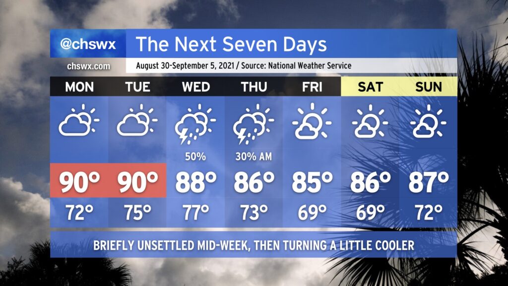
On balance, the week ahead actually looks pretty good. Rain-free but warm conditions (highs ~90°) continue Monday and Tuesday as the ridge of high pressure remains in place across the region. By Wednesday, a cold front and a slug of moisture at least partially sourced from the remnants of Hurricane Ida push southward across the area, scattering showers and thunderstorms across the metro area. The front should clear the area by Thursday, yielding partly cloudy skies and somewhat cooler temperatures with less humidity as we head into the weekend — the first weekend of meteorological fall, which runs from September 1-November 30.
The tropics remain active, but no imminent concerns for the Carolinas
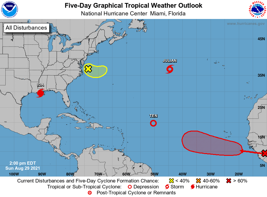
We continue to see a very active tropical Atlantic basin as we head into September. Obviously, Ida is the big story — it maintains 130 MPH winds as it slowly moves inland over Louisiana, with gusts to 146 MPH having been recorded by a private weather station on Grand Isle, LA as the storm made landfall earlier today. The high pressure ridge will steer Ida’s remnant low well to our west, but we won’t be exempt from some of the rainfall as Ida gets caught up along a front mid-week.
Elsewhere, Tropical Depression Ten continues to struggle northward across the central Atlantic and looks destined for the fish. Same with the newly-minted Tropical Storm Julian, which looks to be relatively short-lived as it too moves northward well out of anyone’s way.
NHC is also watching an area of disturbed weather off the Delmarva for possibly some slow development over the next week (though odds as of the 2PM outlook are 10%). Our next depression, though, will likely sprout from a tropical wave poised to move into the Atlantic from Africa over the next day. NHC gives it an 80% chance of being a depression by the end of the work week. This one is way out there, and we’ll have plenty of time to watch it.
The good news is that there are no imminent tropical concerns for the Carolinas. We remain in the peak of the season, though, and so continuing to re-evaluate your hurricane preparedness is important as we have a lot of season to go. It’s much easier to be prepared now than when a storm is bearing down, after all, and as Ida has proven, these can spin up to major storms with not terribly much lead time. “Prepared, not scared” are good words to live by this time of year.