The week ahead: Unsettled at times with more shots of cool air
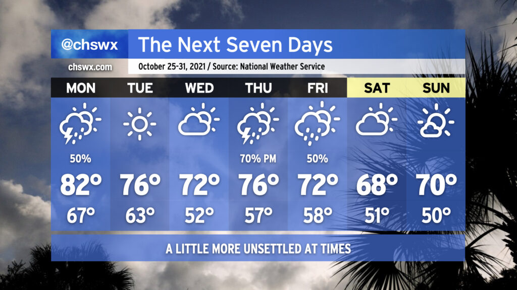
We’ll see a little more of an unsettled pattern going into this week with plenty of temperature peaks and valleys to close October. Monday looks to begin with rain overspreading the area in response to an area of low pressure developing offshore, making for a wet morning commute with some rumbles of thunder possible especially near the coast. Overall rain amounts shouldn’t be terribly heavy, but watch for some slick roads nonetheless as much of the area hasn’t received rain for the better part of two weeks.
A cold front swings through late Monday, bringing with it a slight chance for showers and thunderstorms in the afternoon and evening hours. Thereafter, we will see a nice little cooldown for Tuesday and Wednesday with quiet weather expected. Lows Wednesday morning look to dip into the lower 50s.
We’ll be dealing with a pretty potent storm system heading into Thursday and Friday as a strong upper low digs southward toward the Gulf Coast and brings a cold front with it. Showers and thunderstorms — with a couple stronger storms not out of the question — look to come into the area primarily Thursday afternoon through Friday morning. Temperatures on Thursday peak in the mid-70s and the low 70s on Friday as clouds and maybe a shower or two persist through the rest of the day.
After the front passes through, we’ll get another shot of autumn-appropriate air for the weekend. Lows will flirt with 50° and lower with highs not even reaching 70° on Saturday under partly cloudy skies. Seasonable weather continues for Sunday — solid weather for costumed candy acquisition activities.