The week ahead: Sweaters and salt water flooding
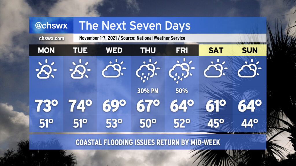
If the random few shots of cool weather in the past few weeks haven’t gotten you to extract your fall attire just yet, you’re going to want to get on that by the end of this week as prolonged below-normal temperatures are in the cards. Indeed, the air is going to take on quite a November feel (though one more characteristic of late November than the beginning) by the weekend. While you’re grabbing the sweaters, though, you might want to reach for the waders, as well, with moderate to major salt water flooding possible around times of high tide by the end of the week.
High pressure wedge to drive temperatures down
Monday and Tuesday start off November in pleasant fashion. We’ll start the week with temperatures right around normal for the beginning of November — lows in the low 50s, highs in the low 70s — with mostly sunny skies expected. By Wednesday, though, a cold front will be dropping southward into the area, bringing cloud cover up and allowing cooler high pressure to wedge in from the north. Northeasterly winds will come up and turn breezy at times.
A storm system looks to affect the area later Thursday into Friday. There’s still some uncertainty around the finer details such as timing, but right now it looks as if the main low pressure track stays to our south. That’ll keep thunder at bay, but overrunning showers certainly look possible particularly on Friday. Said showers along with gusty northeast winds should help keep temperatures pinned to the mid-60s in the afternoon.
By Saturday, though, we will turn much cooler and drier as a strong trough axis aloft moves overhead with high pressure building back in at the surface. Expect lows to bottom out in the mid-40s in the metro area, and perhaps cooler further inland. Highs will only top out in the low 60s on Saturday and in the low-to-mid-60s on Sunday. Winds should stay elevated on Saturday before high pressure settles further in over the area on Sunday, which will also help to scour out a little more of the cloud cover.
Coastal flooding concerns beginning mid-week
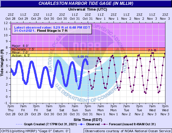
Astronomical factors, namely the new moon at perigee, will contribute to king tides (tides over 6.5′) this week. This, combined with northeasterly winds driven by the high pressure wedge, will create ideal conditions for minor to moderate coastal flooding to develop around times of high tide beginning Wednesday morning. Probabilistic guidance later in the week is quite concerning as it depicts a decent probability of the first major coastal flooding (8.0’+) event of the season as we get into Thursday. We’ll want to watch this closely for potential commute disruptions with the highest tides coming in the morning. Stay tuned.
Follow my Charleston Weather updates on Mastodon, Bluesky, Instagram, Facebook, or directly in a feed reader. Do you like what you see here? Please consider supporting my independent, hype-averse weather journalism and become a supporter on Patreon for a broader look at all things #chswx!