The week ahead: 70s return, but dry weather persists
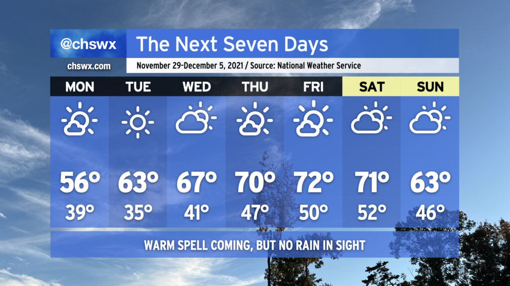
Below-normal temperatures and mostly sunny skies will continue through Tuesday to close out November, meteorological fall, and hurricane season as a weak front gets through overnight to reinforce the cooler airmass in place. Changes are coming, though — as the calendar turns to December and the beginning of meteorological winter, we’re gonna get warmer. The warming trend begins Wednesday, and we’ll look for temperatures in the low 70s for a spell Thursday-Saturday with generally partly cloudy to mostly sunny skies before another front gets through Sunday, sending temperatures a few degrees back below normal.
One thing that’s not forecasted? Rain, at least this week. Persistent dry air continues to keep any sort of rain to a bare minimum across the area with tonight’s frontal passage and will likely at least hamper rainfall development over land with Sunday’s passage, too. Peeking ahead in time, models suggest that the second week of December could see a little bit more in the way of precipitation, but we’ll need to see if that signal holds. For now, though, a good chunk of the Tri-County remains in abnormally dry conditions, with some of the northern fringes creeping into moderate drought. I expect this drought area to expand with Thursday’s Drought Monitor update.
For now, though, we will continue to savor the quiet weather. Have a great week ahead, and Happy Hanukkah to all of you who are celebrating!