The week ahead: Warmth returns with some intermittent shower and storm chances
The week ahead features a return to warmer weather with shower and thunderstorm chances mixed in as the pattern remains somewhat unsettled across the Southeast.
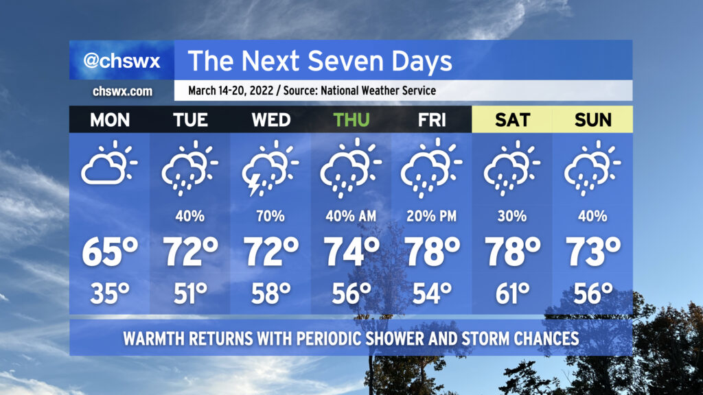
Frost and freeze conditions will give way to warmer — but still a touch below normal — high temperatures across the area on Monday as we warm into the mid-60s. Cloud cover will be on the increase as surface high pressure slips offshore and moisture return improves on the back side of the high. Rain chances begin to tick up later in the day on Tuesday as an upper-level low cuts off over the Arklatex and begins to move eastward, spreading some energy into the area and spawning a surface low pressure system. The cutoff low will move by the Carolinas on Wednesday, and with surface low pressure in place, this will help generate showers and thunderstorms across the area. A couple strong storms might not be out of the question on Wednesday, so that’ll be a trend to watch.
The upper low opens back up into a trough as it moves back into the Atlantic later Wednesday into early Thursday, leaving behind a little bit of ridging and thus quiet weather for the better part of Thursday heading into Friday. Another upper-level low will be moving across the mid-South on Friday, and the associated surface front will approach the area heading into the weekend, bringing some showers and maybe a thunderstorm into our forecast.
Thankfully, there’s no further return to winter in this forecast; no frost and freeze concerns are expected after Monday morning, and temperatures will generally run above normal throughout the week, ranging from the mid-60s on Monday to the low-to-mid-70s Tuesday through Thursday before warming up into the upper 70s to near 80° for Friday and Saturday.