The week ahead: Temperature pendulum swings warmer

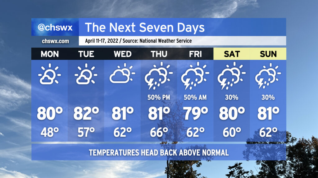
After a rather chilly weekend by mid-April standards in the Lowcountry — we only got to 58° on Saturday, one degree off the record low maximum — above-normal temperatures return to the picture for the week ahead as ridging develops aloft. We stay calm to start the work week, but unsettled weather re-enters the picture beginning Thursday and possibly lasts into the weekend.
Temperatures will take quite a swing on Monday — we’ll start in the upper 40s across the area on our way to 80° in the afternoon under mostly sunny skies. This will get Tuesday off to a warmer start — think mid-to-upper 50s — as we once again head back to the low 80s in the afternoon. Expect similar weather, save for a few more clouds, on Wednesday.
As we get into the second half of the week into the weekend, the upper-air flow becomes a little more zonal (blowing more straight west-to-east) as a trough digs in to our north. This should send a cold front into the area — but perhaps not through it — as we close out the work week, bringing along some shower and thunderstorm chances. Thankfully, the setup shows no signs of repeating the severe weather we experienced last week. Beyond there, model solutions are diverging a bit as far as the weekend goes, but some unsettled weather could be in the cards as we head toward Easter. Regardless, temperatures look to stay above normal through the weekend. We may yet head below normal again the following week, though, but that’s for another day.