The week ahead: Storms exit Monday, yielding a quieter week ahead

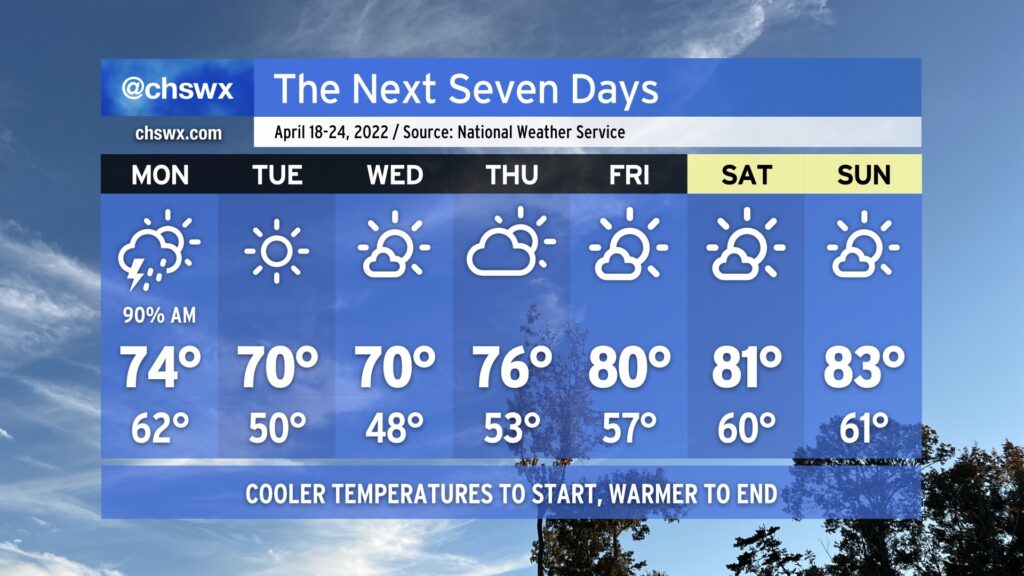
The work week will certainly get off to a meteorologically inauspicious start: Showers and thunderstorms will be ongoing from overnight Sunday heading into Monday morning. Heavy downpours will certainly be possible, so you’ll want to make sure you’re allowing extra time to get where you’re going in the morning. (You know how it gets around here when it rains.)
The bulk of the rain heads offshore by midday, but the short-range and convection-allowing models allow the atmosphere to recover some before the cold front gets through. This is kind of tricky as a high pressure wedge will be trying to build southward at the same time, and models are notorious for under-doing this. I wouldn’t rule out an additional shower or storm forming in the afternoon hours, but that’ll be highly conditional on just how much the atmosphere recovers before the front gets offshore, which is expected generally around mid-afternoon.
From there, though, the week turns nice and tranquil. Tuesday and Wednesday will run much cooler than normal for mid-April as highs only top out around 70° each day despite full sunshine. Ridging will develop aloft thereafter, allowing temperatures to warm into the mid-70s on Thursday and back into the 80s for Friday and the weekend. All the while, we look to remain rain-free given the firm control high pressure will have over our weather at the surface and aloft.
The only potential fly in the ointment will be the risk for minor coastal flooding late Monday night, when high tide around 10-11 PM looks to peak in the 7.2-7.4’ range. Thereafter, though, the effects of the new moon and perigee diminish, bringing a quick and merciful end to this round of coastal flooding.