The week ahead: Drying out a little, and even cooling off some
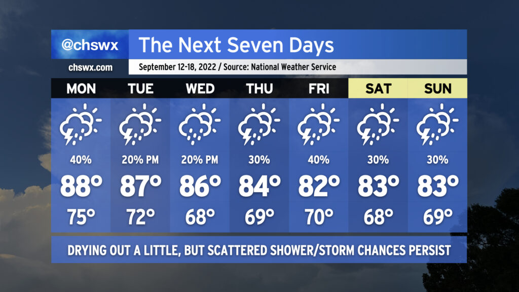
We’ll get a chance to dry out a little bit this week as a front swings through, ushering in some cooler and drier air around midweek. Rain chances don’t totally evaporate, though, and we’ll keep the risk for isolated to scattered storms especially as we approach the weekend. (At least it will feel quite a bit better than it has over the past few days!)
Monday will mark one more day with the unseasonably moist airmass that’s been torturing us for much of recent memory blanketing the area. There will be a slight chance for some morning rain, but much of that should be out of here by sunrise. We’ll wake up to lows in the mid-70s (higher near the coast and downtown) before highs reach the upper 80s under partly cloudy skies. A scattering of showers and thunderstorms will fire off in the afternoon and evening hours. Not everyone gets wet, but some heavy rain will be possible in the strongest storms.
Changes begin to arrive Tuesday as the front moves into the area. We should still see a fairly warm afternoon — highs mid-to-upper 80s are expected — but storm coverage should be a bit more sparse as some drier air begins to work into the area. The front gets through overnight Tuesday and we’ll start Wednesday perhaps in the upper 60s in some spots away from the coast. (Baby steps.) There will be a slight chance of showers coming ashore in the afternoon, but overall expect a partly cloudy day with less humidity than we’ve seen over the past few weeks.
High pressure wedging into the area will keep highs suppressed to the mid-80s Thursday and the low 80s for Friday and the weekend. There will be a chance for showers and maybe a thunderstorm depending on the track of a low that develops along the front, but certainly nothing like the sog-fest that we’ve seen lately.