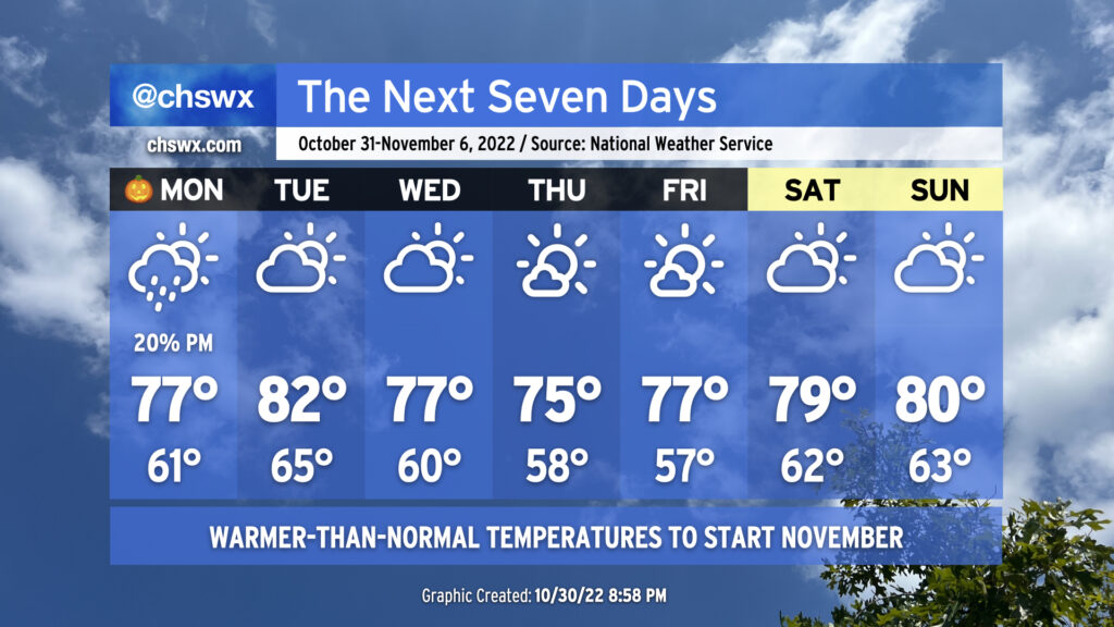
The week ahead: Warmer-than-normal temperatures to start November
The week ahead will look a lot different from this past weekend as we cast away the gray in favor of more sunshine and warmer-than-normal temperatures to kick off November.
Halloween should — emphasis on should — feature the erosion of the persistent cloud cover that’s been plaguing the area for the past few days as a warm front lifts north across the area. As always, the wedge can sometimes throw a wrench into the timing of such things, but overall, we should get some sunshine in before tomorrow is over, which should help push us into the 70s for the first time in three days, though how warm we get will be impacted by how soon the clouds can break up. (We haven’t had a stretch of highs below 70° lasting three days or longer since early February of this year!)
There remains a slight chance of showers with even a rumble of thunder as we get into the warm sector tomorrow, but overall, high-resolution models are keeping much of the area dry through evening. Keep some rain gear handy for trick-or-treating just in case, but right now it looks like much of you won’t need it.
We’ll be out ahead of a cold front on Tuesday as ridging builds in aloft. This will allow temperatures to head into the low 80s in the afternoon. A shower or two can’t totally be ruled out, particularly in the morning, but the front should otherwise pass through with mostly just some scattered cloud cover by Tuesday evening.
The front moves past the area on Wednesday and high pressure begins to build in from the north. A mix of clouds and sun is expected with highs in the mid-70s. Cloud cover decreases for Thursday and Friday as temperatures both days start in the upper 50s and peak in the mid-70s each afternoon. Expansive ridging continues into the weekend, warming temperatures into the upper 70s on Saturday and back to the low 80s on Sunday under partly cloudy skies. Aside from a coastal surface trough possibly kicking off some shower activity over the waters, we look to remain rain-free through the weekend.
Coastal flooding risk diminishes
Water levels with the mid-afternoon high tide Monday could briefly scrape close to 7′ in the harbor. This could put some salt water on Hagood Avenue, even if the water level only tops out around 6.8′. Otherwise, the risk for coastal flooding will end as we get away from the lunar perigee and winds become more unfavorable for higher tidal departures through mid-week. Later this week, winds turn more northeasterly which will help elevate high tides above predicted levels, but without the astronomical influence, it’ll be hard to get high enough departures to cause coastal flooding.
One more thing…
…Daylight Saving Time ends at 2am Sunday. We’ll be able to get that hour of sleep we put into escrow in March back, but it’ll also bring us sunset around 5:30 PM on Sunday, marking the end of 6PM-or-later sunsets until February 10, 2023.