The week ahead: Turning unsettled with possible tropical development near the Bahamas
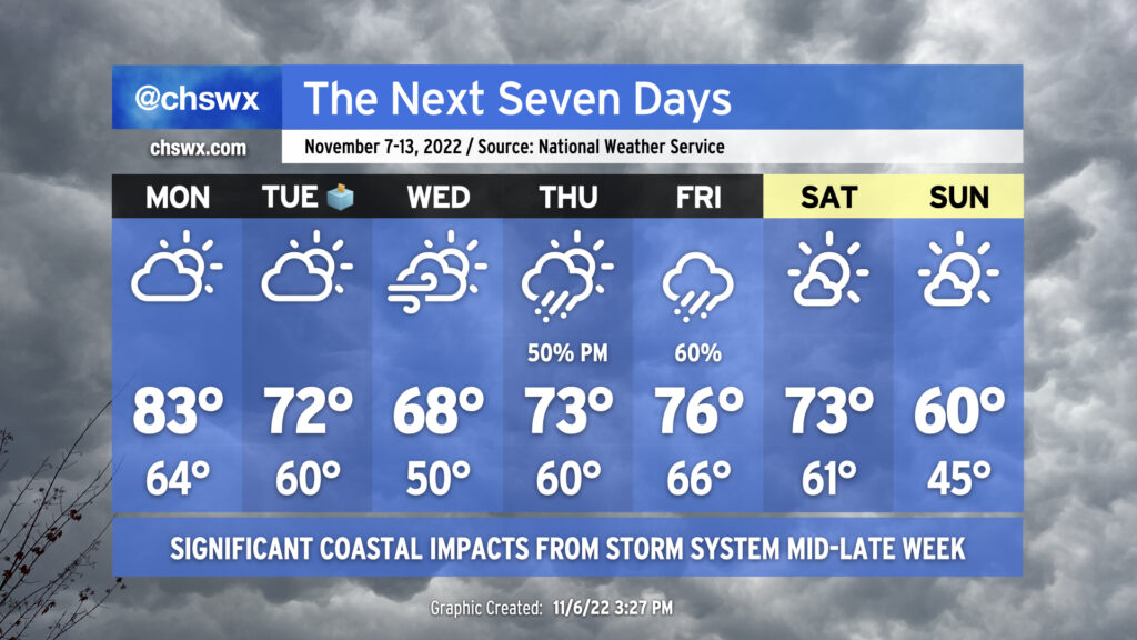
An unsettled week lies ahead, particularly for those of us near the coast, as a possible tropical or hybrid cyclone develops and moves toward Florida around mid-week before recurving with a cold front later in the week. After that front gets through, below-normal temperatures will arrive by Sunday.
Monday: One last near-record warm day
We stay warm to start the week out as the ridge aloft retrogrades westward somewhat and Atlantic high pressure continues to slide offshore ahead of stronger Canadian high pressure. Winds will turn back to the northeast, but that won’t have too much impact on Monday’s temperatures as we look to run into the low-to-mid-80s for one more day. We’ll get close to the record high of 84° set in 1986, in fact, under partly cloudy skies. The morning high tide (6:49 AM) will also need to be watched for the potential for minor salt water flooding in parts of downtown Charleston.
Tuesday: Cooling off, moderate coastal flooding impacts begin
The northeasterlies strengthen around the developing low pressure near the Bahamas to the southeast — likely having been classified as a tropical cyclone by this point in the forecast — and Canadian high pressure wedging into the area from the northeast heading into Tuesday. Significantly cooler and drier air compared to what we’ve experienced over the past few days will work its way into the area despite decent sunshine, holding temperatures to the low 70s in the afternoon.
We look to stay rain-free, which is always good news for Election Day. If you want to get up super-early, you may have a decent shot at seeing the total lunar eclipse peaking just before 6am. Cloud cover trends should be improving, so while a totally unobstructed view of the eclipse isn’t likely in the cards, you should still have a decent shot at seeing the red moon one more time before the next total lunar eclipse visible from the US…in 2025!
Coastal flooding concerns will tick up on Tuesday as northeasterly winds strengthen, with minor to moderate flooding in the forecast around the morning high tide. Said tide is currently predicted to peak at 7:31 AM around 7.5′; this height is about where we start to see road closures begin to pop up, so we’ll want to keep an eye on this for minor commute impacts for downtown Charleston.
Wednesday: Even cooler, turning more gusty
The persistent cold advection from what’s anticipated to be a very pronounced wedge of high pressure will continue, and temperatures will begin to run below normal, with highs only topping out in the upper 60s with a mix of clouds & sun. Expect winds to turn even stronger, especially at the coast, as the pressure gradient between the expected tropical cyclone to the south and the wedge holding across the area continues to tighten. Gusts to 30 MPH, especially near the coast, will be possible Wednesday. We should get one more rain-free day in, though moisture looks to begin to increase later in the day Wednesday as the low gets closer to the Florida coast.
Concerns for at least moderate coastal flooding will continue around the 8:11 AM high tide. Water level guidance suggests there is a decent chance of high-end moderate to low-end major flooding with this high tide. Given that this tide will coincide with the morning commute, it is possible there could be some traffic issues around peninsular Charleston as well as along Long Point Road near Snee Farm in Mt. Pleasant. We’ll have to watch water level trends closely for Wednesday and beyond.
Thursday and Friday: Rain chances increase, more flooding concerns
As one would usually expect, forecast details become a little more fuzzy Thursday and Friday. The general thinking, though, is that the low pressure center begins to turn north and northeast as the high pressure wedge breaks down and a trough (and associated cold front, for that matter) moves in from the west. Rain looks to begin Thursday afternoon as a warm front pushes ashore, sending temperatures back into the low 70s in the afternoon. Gusty winds, perhaps touching 30-40 MPH (especially at the coast), look to continue.
By Friday, the low pressure system, which is likely undergoing extratropical transition at this point, looks to strafe the area during the day with gusty winds and periods of heavy rain. How fast it gets out of here is a big question mark — the ECMWF is a little faster with the trough and gets it out of here before daybreak Saturday, but the GFS is about six hours slower and keeps some rain in the area a little longer as a result. Right now, Friday looks to remain on the warm side with highs in the mid-70s.
Moderate to potentially major coastal flooding impacts should recur Thursday and Friday mornings with continued strong onshore flow and lingering astronomical impacts from Tuesday’s full moon pushing water levels well over flood stage. Guidance is spitting out some pretty big water level numbers right now — well into 8’+ territory — but it also sometimes gets a little too excited about these things, so we’ll need to wait and see. Stay tuned.
Saturday and Sunday: Fall weather returns
As low pressure moves away Saturday, a strong cold front will be approaching from the west with a much, much cooler and drier airmass that will certainly placate the fans of more traditional cooler fall weather. While we’ll be in the low 70s on Saturday, Sunday could feature highs struggling to get to 60° in the wake of this front despite mostly sunny skies — well below normal for this point in November. Hang in there, fall weather fans — the cooler air is coming.
Stay tuned to forecast updates over the next few days as we in #chswx nail down the exact timing and magnitude of impacts from this expected coastal storm.
Follow my Charleston Weather updates on Mastodon, Bluesky, Instagram, Facebook, or directly in a feed reader. Do you like what you see here? Please consider supporting my independent, hype-averse weather journalism and become a supporter on Patreon for a broader look at all things #chswx!