Tropical Storm, Storm Surge Watches hoisted in advance of Nicole; what to expect
We have a busy few days of weather ahead of us as Tropical Storm Nicole makes landfall on Florida, perhaps as a hurricane, and then turns north and northeast to strafe the Carolinas with heavy rain, wind, and maybe even some severe weather.
10 PM NHC advisory: Knocking on the door of hurricane strength
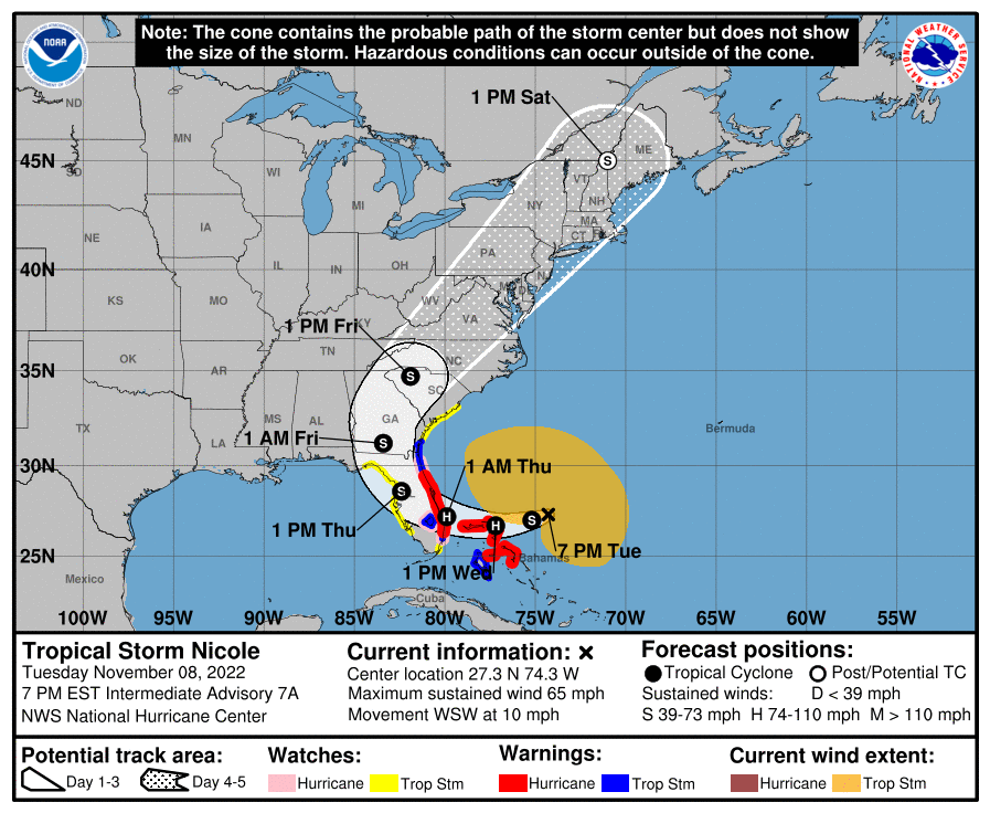
As of the 10PM advisory, Nicole was approaching the Bahamas as a 70 MPH tropical storm, knocking on the door of hurricane strength. It’s moving WSW at 10 MPH, and its minimum central pressure is down to 984mb. Hurricane Warnings are out along the Florida east coast and in the northern Bahamas as Nicole is expected to strengthen to a Cat 1 hurricane by tomorrow.
Further up our way, a Tropical Storm Watch is up for Berkeley and Charleston counties, and a Storm Surge Watch is now in effect for Charleston County. Meanwhile, with the 10am advisory, Charleston Harbor was upgraded to a Tropical Storm Warning. This means that tropical storm conditions and storm surge are possible in the next 48 hours. I expect these to get upgraded to warnings tomorrow; get ready for your phones to lose their collective minds once more.
Note the very wide tropical storm force wind field — effects from this storm have and will continue to extend very far from the center of circulation. This is one where the center path is not going to make too much of a difference without serious changes; track guidance is pretty solid keeping this one to our west this go-around. (One nice thing about November storms is that the steering is usually pretty explicit.)
Let’s dig into the timeline of what to expect:
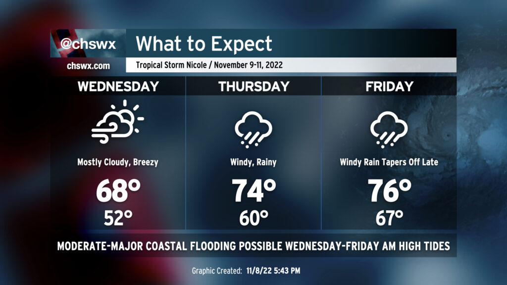
Wednesday: Breezy conditions continue, coastal flooding expected around high tides
We stay breezy and rain-free for one more day on Wednesday, but Nicole’s effects will be felt as the continued onshore flow drives water levels well into moderate coastal flooding thresholds (bordering on major flooding) for the morning commute. Expect water levels to peak between 7.8-8.0′ with the 8:11am high tide, with coastal flooding possible 2-3 hours on either side of said tide. Scattered to numerous road closures are possible, with routes such as the off-ramp to 61 from 17 heading into West Ashley being completely cut off by salt water and areas around the Citadel becoming impassable. Another round of moderate coastal flooding is forecast with the 8:30pm high tide, as water levels are forecast to peak between 7.6-7.8′. This could cause a renewed round of road closures; if downtown is in your evening plans, be ready to be rerouted around flooded roads.
Temperatures will run on the cool side given plenty of cloud cover and the persistent cool and dry northeasterly wind; highs shouldn’t get out of the upper 60s in the afternoon.
Thursday: Major coastal flooding, heavy rain begins, possible tornado threat
Thursday looks to represent the peak of the coastal flood threat across the area. An 8.4′ high tide is predicted around 8:50am, with flooding likely occurring once again about 2-3 hours either side of said tide. Numerous road closures will occur, with issues creeping up in some of the less-frequently-affected spots such as James Island along Harbor View Road and perhaps even in parts of West Ashley near the Stono. Expect numerous issues right smack dab in the middle of the morning commute — be patient, or just work from home if you have to head downtown.
Making matters dicier, rain is expected to begin Thursday morning as warm, moist maritime air pushes inland, eroding the cool and dry wedge of high pressure. This rain could be heavy at times, exacerbating any salt water flooding and perhaps contributing to a longer-duration flooding event in downtown Charleston. This potential will have to be watched very, very closely. Guidance also suggests another significant round of salt water flooding could recur with the evening high tide. This isn’t explicitly in the forecast as of now, but given that onshore flow should continue, the evening high tide should at a minimum approach minor flood stage.
As we get into Thursday afternoon, we will also have to watch carefully for an increasing tornado threat as Nicole begins to move north and northeast, staying to our west and placing us on the “dirty” side of the storm. Winds at the surface will veer to the southeast throughout the afternoon and evening, advecting in sufficiently unstable air and setting up a favorable vertical shear profile for rotating storms within rain bands. Based on the current expected forward speed of the storm, the tornado threat looks to continue overnight Thursday into Friday, and so you’ll want to make sure that you have redundant, reliable ways to hear severe weather warnings that can wake you. Make sure one of the ways you get warnings isn’t tied to your smartphone. A NOAA Weather Radio is great for this — the Awendaw transmitter is fixed and sounds stronger than ever, BTW — and should be in everyone’s safety kit.
Regardless of the tornado threat, the wind threat should also begin to pick up later Thursday. 850mb winds exceeding 50 knots could easily mix down to the surface in rain bands, producing gusts 40-50 MPH even away from the coast.
Friday: Rain continues, maybe a period of strong winds, minor morning flooding, then improving weather
The risk for some severe storms will persist into Friday morning with another round of minor to moderate salt water flooding expected on top of rain bands, which could drop another inch or two of rain before it’s all said and done. Once again, the flood threat will be paramount especially in coastal communities. The wind risk looks greatest Friday before sundown, with gridded NWS forecasts suggesting a band of 30-40 MPH winds cutting across the Tri-County in the early afternoon as Nicole departs the area. We will see improving conditions begin to move in later in the day, though, with rain likely to shut off by evening and winds starting to slacken.
How to get ready
While we’re certainly not expecting a hurricane strike (unlike what we saw with Ian), Nicole will come with plenty of hazards to be ready for. A few things you can do to prepare:
- Take precautions against flooding — perhaps long-duration flooding — particularly if you live downtown. There’s no word yet on garages just yet, but I suspect we’ll hear something on Wednesday.
- Have flashlights and batteries ready to go. Make sure the battery in your weather radio is fresh in case you lose power. Keep cell phones plugged in especially on Thursday and Friday (always be charging!). Isolated to scattered power outages are expected; if you’re one of those who loses power, you’ll be happy you were ready.
- Bring in loose items. You don’t want to have stuff from your yard blowing toward your neighbors.
- Review your tornado safety plan in case a warning is issued for your area. Remember: get into an interior room on the lowest floor of your home, putting as many walls between you and the outside as possible. If you’re in an apartment, check with your property manager on what to do in the event of a tornado warning, or just make a real good friend on the first floor.
The good news? Saturday looks great, and much cooler air moves in by Sunday with mostly sunny skies and highs only around 60°, kicking off several days of legit sweater weather. 🙂
Follow my Charleston Weather updates on Mastodon, Bluesky, Instagram, Facebook, or directly in a feed reader. Do you like what you see here? Please consider supporting my independent, hype-averse weather journalism and become a supporter on Patreon for a broader look at all things #chswx!