The week ahead: Get ready for an Arctic outbreak
The week ahead will be primarily unsettled before an outbreak of Arctic air overspreads the area for Christmas weekend, bringing the coldest temperatures so far this season with potentially hazardous wind chills on Saturday morning.
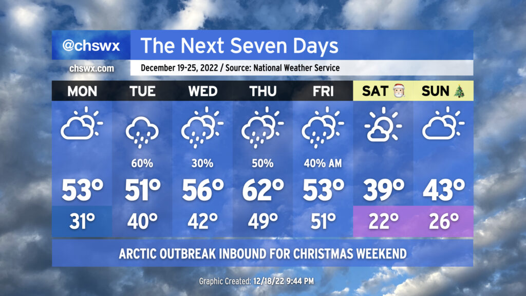
We’ll start Monday with temperatures below freezing away from the immediate coast as light winds and mostly clear skies provide excellent radiational cooling conditions. The northeasterly breeze will make it feel closer to the mid-20s, so be sure you’re bundled up. Temperatures will only rise into the low 50s in the afternoon as high pressure continues to build from the north. Cloud cover will increase throughout the day Monday as moisture returns to the area, but we stay dry.
Dry weather comes to an end Tuesday as high pressure wedges in some from the north, a coastal trough forms, and low pressure develops in the Gulf. This will help wring out some rain across the area with cloudy skies otherwise. Temperatures will be chilly but still well above freezing — around 40° in the morning, but only low 50s in the afternoon as rain-cooled air and overcast prevent much in the way of significant warming.
A coastal low looks to develop Wednesday into Thursday, which will help keep rain chances in the forecast particularly for Thursday. Highs on Wednesday will top out in the mid-50s, while some warmer air should push into the area for Thursday, yielding highs in the lower 60s.
Savor that, because on Friday, a very strong cold front will push through, bringing much colder and drier air into the area. We’ll start Friday in the low 50s with some showers in the area, but once the front gets through, strong cold advection will counteract clearing skies and keep temperatures suppressed to the mid-50s at best. Winds will turn quite gusty, and NWS notes that a Wind Advisory might be needed for gusts over 40 MPH at least on Friday. Finally, it’s worth noting that there’s good model agreement that moisture will be stripped out of the atmosphere as the colder air moves in, putting the kibosh on any winter weather chances. (Sorry, y’all.)
Christmas Eve will start exceptionally chilly. The air temperature will fall to the low 20s across the metro (and I won’t rule out teens in more rural areas). Factor in continued breezy conditions, and wind chills could drop into the single digits. This is Wind Chill Advisory territory for our neck of the woods, and it’ll be something to keep an eye on. Despite full sunshine, highs on Christmas Eve may not crack 40°. If that verifies, it’d be only the third time that’s happened here since records started in 1937, and the first time since 1989, when we had 8″ of snow on the ground to bring our region’s only White Christmas on record.
Christmas Day looks to only be marginally but not meaningfully warmer. We’ll have another round of pipe-busting cold in the morning, followed by temperatures struggling into the low 40s in the afternoon under partly cloudy skies. The forecast high of 43° would be a top-ten coldest Christmas Day on record; we’ll certainly see how this evolves. Stay tuned — and stay warm!
Follow my Charleston Weather updates on Mastodon, Bluesky, Instagram, Facebook, or directly in a feed reader. Do you like what you see here? Please consider supporting my independent, hype-averse weather journalism and become a supporter on Patreon for a broader look at all things #chswx!