Rest of the work week: Unsettled conditions continue, then turning much colder Friday
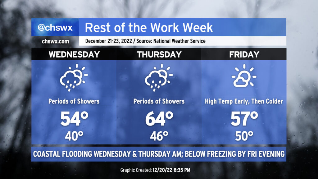
Wet weather will continue on and off through early Friday before an outbreak of Arctic air brings much colder air and strong winds to the area for Christmas weekend.
Tuesday night into Wednesday
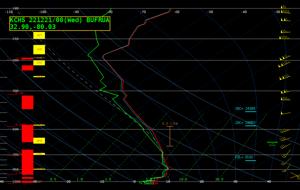
Cold rain — and that’s it — will continue for much of the night as upper-level energy and moisture transport continues to move atop a cold wedge of high pressure at the surface. A pronounced warm nose (as seen on this evening’s weather balloon) will keep precipitation liquid as it falls into the wedge, and temperatures should generally level off in the upper 30s to around 40° for much of the night.
Showers will taper — but might not stop completely — as we get toward daybreak Wednesday morning. A break or two in the overcast is possible Wednesday, and we should see temperatures warm into at least the low 50s as a result. Rain will move back in overnight as low pressure develops offshore.
The main weather hazard early Wednesday morning will be the tide: it looks as if we’ll notch our 69th coastal flooding event of the year — good to make 2022 the second most coastal flooded year on record, only behind 2019 — around the 5:44am high tide, which is forecast to top out between 7.3-7.5′. This should be enough to cause a few road closures in downtown Charleston, so if you have early commute plans, be aware of this potential. We should see rain tapering off around that time, thankfully, so there’s no expectation that it will add to any flooding issues.
Wednesday night into Thursday
Rain should return later Wednesday and will ramp up Thursday morning as low pressure develops offshore and moves northward. We could see some periods of heavy rain coinciding with Thursday morning’s high tide (~6:31am), which will be capable of producing moderate to possibly even major flooding, so be alert to that possibility especially if you commute into downtown.
Winds will swing around to the west and southwest later in the day, giving us one more taste of the 60s before the icebox opens up on Friday. Shower chances will continue off and on throughout the day, with the risk of a thunderstorm not out of the question given some elevated instability. No severe weather is expected here in the Lowcountry, though.
Rain tapers off overnight, but not before we see another half-inch to an inch of rain in some spots before it’s all said and done.
And then there’s Friday.
Friday into Saturday morning
Friday will be a weird day, with the temperature curve seemingly going in reverse. The NWS forecast high of 57° may very well be reached before many of us wake up Friday morning. We should see the cold front approach and get through the area around or just after daybreak. While the exact timing will still need fine-tuning, the bottom line is this: Temperatures will be falling precipitously for much of the day, even as clouds scour out and give way to sunshine. Some spots inland will be below freezing before the sun goes down; closer to the metro area, expect subfreezing temperatures to set in shortly after sunset. When it’s all said and done, temperatures will have dropped as much as 20-25° in about 12 hours’ time.
Winds will be another potentially significant factor. Expect gusts to be pushing 35-40 MPH as cold air rushes into the area, potentially prompting Wind Advisories particularly during the morning and early afternoon. While gusts should subside later in the day, winds will remain generally elevated in the 20-25 MPH range through sunset. This should drive wind chills below freezing by mid-afternoon, so be sure you’re dressed for the weather that’s coming and not the weather you’re feeling when you head out of the house on Friday.
Drip a faucet Friday night into Saturday as temperatures plunge into the low 20s (and perhaps upper teens further inland). Windy conditions will persist into Saturday morning, when Wind Chill Advisories appear likely as feels-like temperatures dip perhaps into the single digits at times. You’ll want to be quite bundled up if you’ve got some last-minute Christmas shopping to take care of, that’s for sure. Cold temperatures will last well into next week, too, though there is some signs in the long range that we may flip back warmer in time for New Year’s. Stay tuned, and stay warm!
Follow my Charleston Weather updates on Mastodon, Bluesky, Instagram, Facebook, or directly in a feed reader. Do you like what you see here? Please consider supporting my independent, hype-averse weather journalism and become a supporter on Patreon for a broader look at all things #chswx!