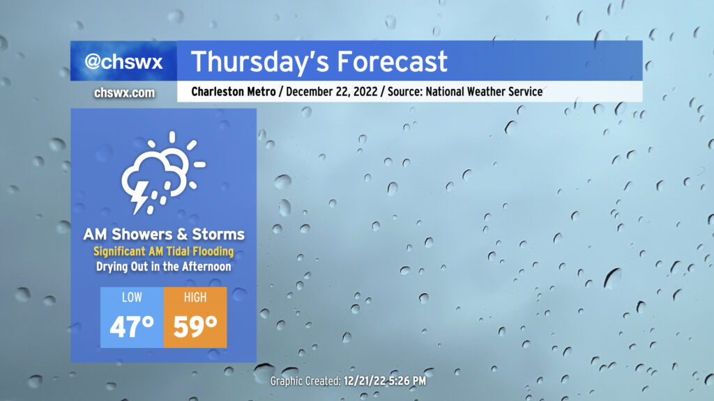
Thursday: Soggy start, with moderate to major tidal flooding possible
Thursday will bring somewhat complex weather to the Lowcountry with a very soggy start to the day as low pressure moves across the area, followed by a dry slot moving into the area in the afternoon to shut off the rain. Of course, we continue to monitor the progress of an incredibly potent Arctic cold front as it progresses across the country, with it expected to clear our area on Friday.
Thursday morning: Showers, maybe some thunderstorms, and tidal flooding
The incoming cold has captured a lot of headlines, but we don’t want to sleep on Thursday morning and the potential for disruptive weather due to heavy rain and coastal flooding. Low pressure developing offshore will push northward toward the coast early in the morning. Depending on the exact track of the low, this should push at least some elevated instability into the area, giving us a chance at a few rumbles of thunder and some heavier rain rates within those cells.
At the same time, water levels in the harbor will be heading well into flood stage. The current NWS forecast is for the 6:37am high tide to top out around 7.7-7.9′, solidly in moderate flood stage and approaching major flood stage (8’+). The forecast heights alone will be enough to cause scattered to numerous road closures in downtown Charleston, but with the risk of a quick half-inch of rain within thunderstorms on top, this could portend a more widespread flooding risk for the peninsula. Bottom line: Stay alert for flooding if you are traveling early in the day downtown. The good news is that rain looks to shut off by midday as the low pushes further north and a dry slot moves overhead; it’s probable that we’ll get some sunshine to peek through before Thursday’s all said and done, too.
Thursday morning may be quite mild, depending on the track of the low. A little further to the south and west, and we could see temperatures jump into the 60s for at least a brief time as an associated warm front pushes ashore. Once the low lifts north, we could see temperatures cool off briefly before a more general warming trend establishes itself for the rest of the day as winds go southwesterly ahead of the big front. Thankfully, it looks like our run of 40s will come to a close for at least one day, and we’ll see highs top out in the mid-to-upper 50s in the afternoon. (Savor that…it won’t last long.)
I can’t stress enough that if you are headed out of town for Christmas, Thursday is probably going to be your last best opportunity to prepare your home for the incoming cold snap. Drip a faucet, wrap outdoor pipes and spigots, and keep some semblance of heat running.
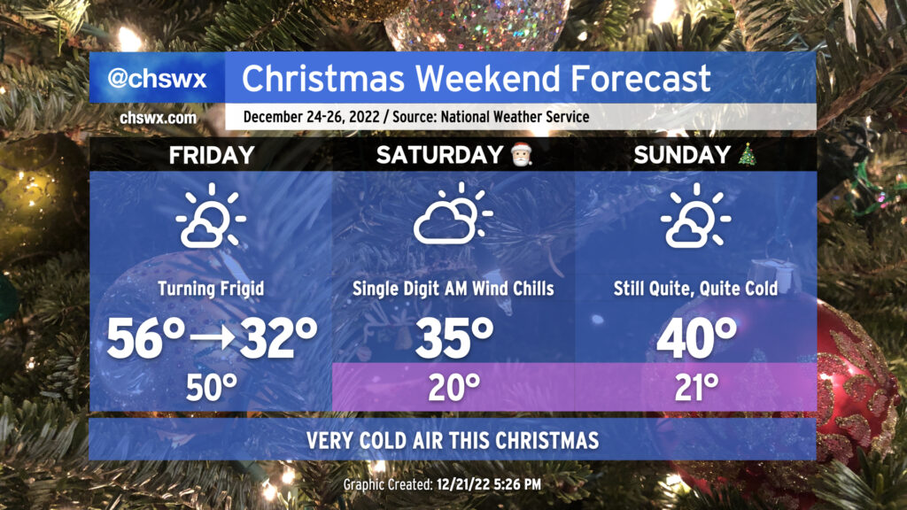
Christmas weekend: Arctic blast arrives Friday with gusty winds and a sharp cooldown
The forecast for the Arctic blast to arrive on Friday and put us into the icebox for Christmas weekend remains in good shape, and now the question of timing as it moves by becomes the primary forecast challenge.
Friday
We should see the front get through Friday morning. There may be a shower or two along the front due to the sheer amount of frontal forcing, but moisture will be increasingly difficult to come by, and there’s still no expectation of any winter weather in the Lowcountry. It’s probable that we’ll set our daily high (56° as forecasted by NWS) before most of us are awake. From there, winds kick up significantly, with gusts 30-40 MPH well in reach throughout the day as cold air advects into the area. Temperatures will fall precipitously throughout the day despite increasing sunshine, with subfreezing temperatures possible across a fair bit of the area before sunset. Wind chills will run well into the 20s ahead of the arrival of the subfreezing air temperatures, too, so you’ll want to be bundling up as you head out to lunch.
By sunset, all areas should be below freezing. Cold advection will continue, with elevated winds expected overnight into Saturday. Lows should drop to the teens closer to I-95 while low 20s are the main expectation in the Charleston metro. Freezing temperatures should reach all the way to the coastline given the strength of the cold advection. Everyone on Friday night should have pets in, plants covered or inside, vulnerable loved ones accounted for, and pipes wrapped with a faucet dripping.
Saturday
Saturday morning will be downright cold. Temperatures in the low 20s combined with continued winds around 10-15 MPH with higher gusts will contribute to wind chills as low as the single digits. NWS anticipates issuing very rare Wind Chill Advisories for Saturday morning given how low they are expected to go. Despite a reasonable amount of sunshine under partly cloudy skies (with high clouds the main contributor to said sky cover), temperatures will struggle into the mid-30s in the metro area during the day Saturday. It’s possible that temperatures may not get above freezing further inland near I-95. Even when temperatures do get above freezing, it looks to be just for a limited time as temperatures will dip back below 32° quickly after sunset. Therefore, you’ll want to put the same cold-weather protocols in place for Saturday night/Sunday morning as you did on Friday.
It’s worth noting that the record low maximum temperature for Christmas Eve at the airport is 33°, set in 1989. This record is certainly in jeopardy. Keep in mind, too, that the 1989 record low maximum was set with 8″ of snow cover — we won’t have that this go-around. Says quite a bit about the airmass moving in!
Sunday
We’ll start Christmas morning once again in the low 20s, with another round of Wind Chill advisories possible. (Some guidance is going a little warmer, perhaps due to lingering high cloud cover, but that won’t matter terribly much in the grand scheme.) Cold advection will finally calm down during the day on Sunday, and the airmass will begin to very, very slowly modify. Expect highs to top out around 40° in the metro area before heading back well below freezing for Monday morning. Morning lows at or below freezing are forecast through next Wednesday, though, even as highs gradually warm back to the 50s by Wednesday.
Stay warm and stay tuned to forecast updates as we head toward Christmas weekend!
Follow my Charleston Weather updates on Mastodon, Bluesky, Instagram, Facebook, or directly in a feed reader. Do you like what you see here? Please consider supporting my independent, hype-averse weather journalism and become a supporter on Patreon for a broader look at all things #chswx!