Christmas weekend: Arctic outbreak arrives
A very potent cold front will be coming through early Friday, bringing strong, gusty winds, dangerous wind chills, and several mornings in a row of pipe-busting cold for the Christmas holiday weekend.
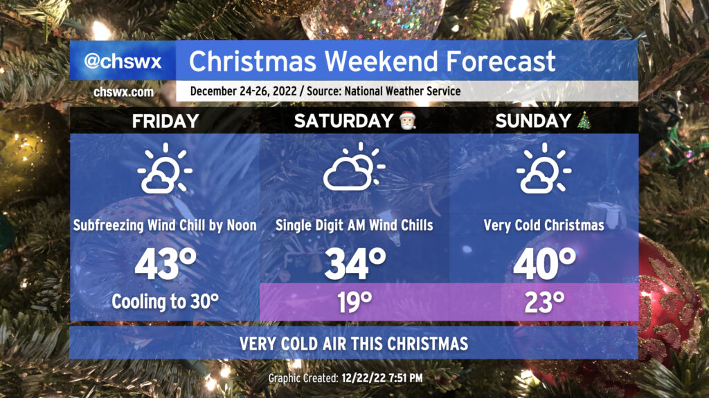
Friday
The front will come through near daybreak Friday morning. There may be a shower or two along the front due to the sheer amount of frontal forcing, but moisture will be increasingly difficult to come by, and there’s still no expectation of any winter weather in the Lowcountry. This is going to be one of those days where we set the daily high while most of us are asleep — temperatures should peak around 49-50° early in the morning before the front gets through. From there, winds kick up significantly, with gusts 30-40 MPH well in reach throughout the day as cold air advects into the area. A Wind Advisory will be in effect for Friday from 6am-9pm to highlight this concern, which could lead to some sporadic power outages and minor tree damage.
Temperatures will fall precipitously throughout the day despite increasing sunshine, with subfreezing air temperatures possible across a fair bit of the area before sunset. And don’t get me started on the wind chill — it’ll be falling into the teens by evening and will just continue to plummet. A Wind Chill Advisory will go into effect at 7pm Friday through 11am Saturday to highlight the risk for dangerous wind chills.
By sunset, all areas should be below freezing. Cold advection will continue, with elevated winds expected overnight into Saturday. This evening’s forecast update brings low temperatures in the high teens all the way into the Charleston metro area, with 20s near the immediate coast. This won’t be like a lot of other freezes — freezing temperatures should reach all the way to the coastline given the strength of the cold advection. Everyone on Friday night should have pets in, plants covered or inside, vulnerable loved ones accounted for, and pipes wrapped with a faucet dripping. This is especially important for homes on the beaches that are elevated and may have plumbing that is more vulnerable to the elements.
Saturday
Saturday morning will be downright cold. Temperatures in the upper teens to low 20s combined with continued winds around 10-15 MPH with higher gusts will contribute to wind chills as low as the single digits. As mentioned, a Wind Chill Advisory will be in effect through 11am for the most dangerous conditions, though wind chills will continue to run in the low to mid-20s pretty much all day. Despite a reasonable amount of sunshine under partly cloudy skies (with high clouds the main contributor to said sky cover), temperatures will struggle into the mid-30s in the metro area during the day Saturday. It’s possible that temperatures may not get above freezing further inland near I-95. Even when temperatures do get above freezing, it looks to be just for a limited time as temperatures will dip back below 32° quickly after sunset. Therefore, you’ll want to put the same cold-weather protocols in place for Saturday night/Sunday morning as you did on Friday.
It’s worth noting that the record low maximum temperature for Christmas Eve at the airport is 33°, set in 1989. This record is certainly in jeopardy. Keep in mind, too, that the 1989 record low maximum was set with 8″ of snow cover — we won’t have that this go-around. Says quite a bit about the airmass moving in!
Sunday and beyond
We’ll start Christmas morning once again in the low 20s, with another round of Wind Chill advisories possible. (Some guidance is going a little warmer, perhaps due to lingering high cloud cover, but that won’t matter terribly much in the grand scheme.) Cold advection will finally calm down during the day on Sunday, and the airmass will begin to very, very slowly modify. Expect highs to top out around 40° in the metro area before heading back well below freezing for Monday morning. Morning lows at or below freezing are forecast through next Wednesday, though, even as highs gradually warm back to the 50s by Wednesday.
If there’s one bit of good news in all this, it’s that we’ll be singing a different tune come New Year’s. Trends in the long-term forecast show above-normal temperatures in our future to close out 2022. The latest NWS long-term forecast shows highs getting into the 50s by Wednesday and into the 60s by Thursday. It’ll feel almost summer-like after these next few days! Hang in there and stay warm…
Follow my Charleston Weather updates on Mastodon, Bluesky, Instagram, Facebook, or directly in a feed reader. Do you like what you see here? Please consider supporting my independent, hype-averse weather journalism and become a supporter on Patreon for a broader look at all things #chswx!