Record cold expected for Christmas Eve; not much warmer Christmas Day
Christmas weekend has arrived, and so has that unreal shot of Arctic air. Temperatures peaked around 56° at 8:49am just before the front passed by the airport. From there, temperatures have been steadily dropping throughout the day as dewpoints headed into the low single digits, making for a very dry feel to the air.
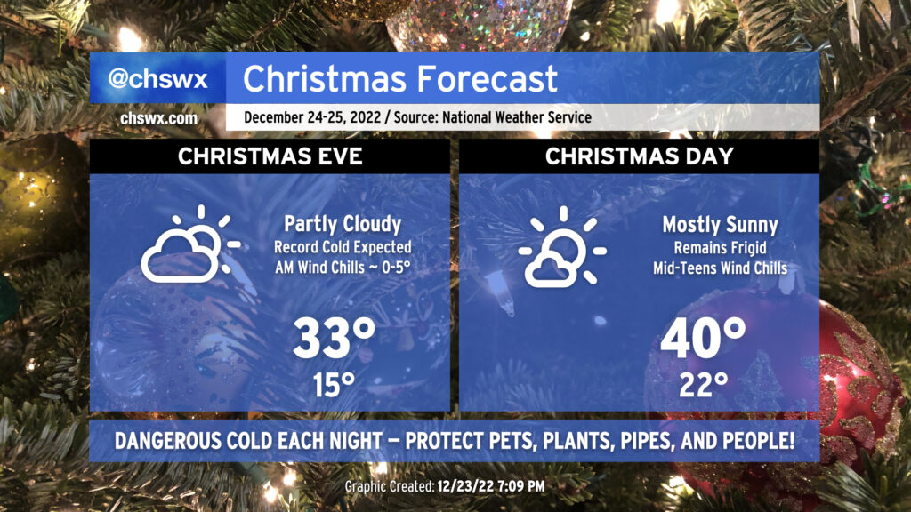
The low single digits is where we will find our wind chills tomorrow morning as air temperatures plummet to around 15°, which if verified would break the record low of 16° set in 1989. Factor in a continued elevated westerly wind around 10-15 MPH, and it will feel closer to about 0-5° in the morning. A Wind Chill Advisory will be in effect from 10pm tonight through 11am Saturday as a result. If you must be out, layer up!
It’s conceivable we spend much of Saturday below freezing, with highs perhaps only peeking above freezing quickly at 33° — which would tie the Christmas Eve 1989 record low maximum. It’s worth noting that in 1989, these temperatures were due in part to the 8″ of snow cover that was in place. We have no such snow cover this time, which speaks volumes about the potency of this Arctic airmass.
Christmas morning will be “warmer” with lows dropping into the mid-20s. Wind chill factors will run in the mid-teens, which is still brutal by any measure for this part of the world, so once again, layers will be necessary attire if you’re headed out for services (or just coffee) on Sunday. Record temperatures will not be threatened this go-around, though: the record low max of 27° and record low minimum of 11°, both set in 1983, remain safe. A little more in the way of sunshine on Sunday as opposed to Saturday will help temperatures get to around 40° in the afternoon, but the persistent west and northwesterly wind around 5-10 MPH will continue to make it feel closer to freezing.
Warming shelters to open tonight through this weekend
Warming shelters have been set up across the Lowcountry starting tonight. If you know someone who is unhoused or otherwise does not have a warm place to be the next few nights, these will be good spots to stay out of the cold:
Friday night
- Holy City Missions at Aldersgate United Methodist Church; 1444 Remount Road, North Charleston
- Hibben United Methodist Church; 690 Coleman Blvd, Mt. Pleasant
- Goose Creek United Methodist Church; 142 Red Bank Road, Goose Creek
Saturday and Sunday
- Holy City Missions at Aldersgate United Methodist Church
- Hibben United Methodist Church
- Goose Creek United Methodist Church
- Seacoast Church, Summerville; 301 E N 5th Street, Summerville
I hope everyone has a warm and safe place to be tonight and this weekend. Make sure your sensitive plants are covered or brought in, your pets are inside and warm, you have your outdoor faucets wrapped and an indoor faucet dripping, and the people in your life are safe and sound.
Follow my Charleston Weather updates on Mastodon, Bluesky, Instagram, Facebook, or directly in a feed reader. Do you like what you see here? Please consider supporting my independent, hype-averse weather journalism and become a supporter on Patreon for a broader look at all things #chswx!