Sprawling high pressure aloft over the central part of the country will keep warmer-than-normal temperatures in the forecast through Christmas and heading into the weekend. There are changes coming, though, in the form of an Arctic blast that will bring 2025 to a chilly end.
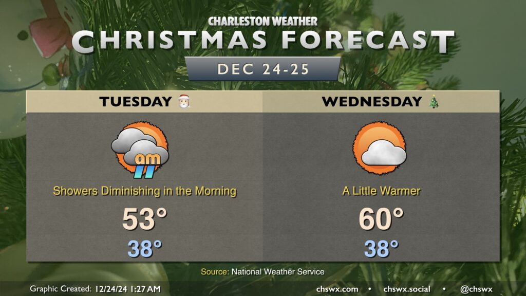
We get Christmas Eve off to a chilly and wet start on Tuesday, but showers will diminish throughout the day as low pressure pulls away from the area. Temperatures bottom out in the upper 30s to around 40°, with wind chills making it feel even cooler. As the day goes on, temperatures will head into the low to mid-50s in the afternoon with some breaks in the clouds developing.
Christmas morning will start out seasonably cool, with lows once again topping out in the upper 30s to around 40°. It’ll be a bit warmer of a day with more sunshine expected; highs should peak around 60° in the afternoon. Northeasterly winds will be a touch on the breezy side, but otherwise, no concerns for Christmas Day.
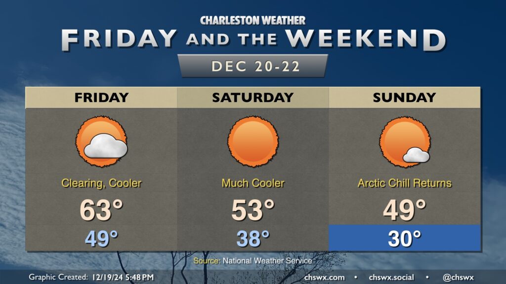
Temperatures will tumble once again as we head into the weekend as a couple shots of cooler and drier air work their way in. Friday will feature decreasing cloud cover throughout the day as the first round of drier air continues to filter in; expect lows in the upper 40s to around 50° to warm to the mid-60s in the afternoon.
A second, more potent, shot of Arctic air works into the area overnight Friday. We’ll feel it Saturday morning as lows head down into the upper 30s. Ongoing cool advection will keep highs in the low to mid-50s despite plenty of sunshine.
Sunday morning dips below freezing for the first time in a few days, with lows in the upper 20s to around 30° expected away from the coast. Highs will once again struggle and may not make it out of the 40s with more sunshine expected.
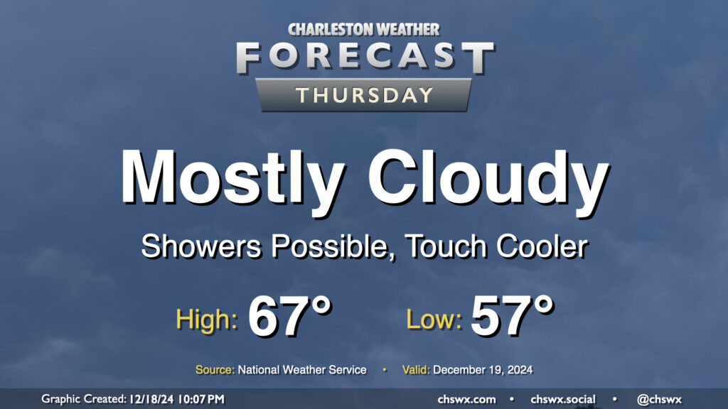
A front will pass through overnight Wednesday into Thursday, but we’ll keep cloud cover around and maybe even a shower or two as a trough of low pressure hangs around for one more day. Temperatures will start in the mid-to-upper 50s once again, but we’ll warm to just the mid-60s with the cloud cover and a somewhat cooler and drier airmass working its way in.
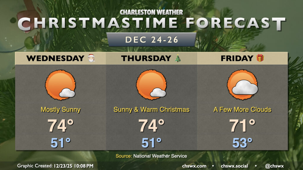
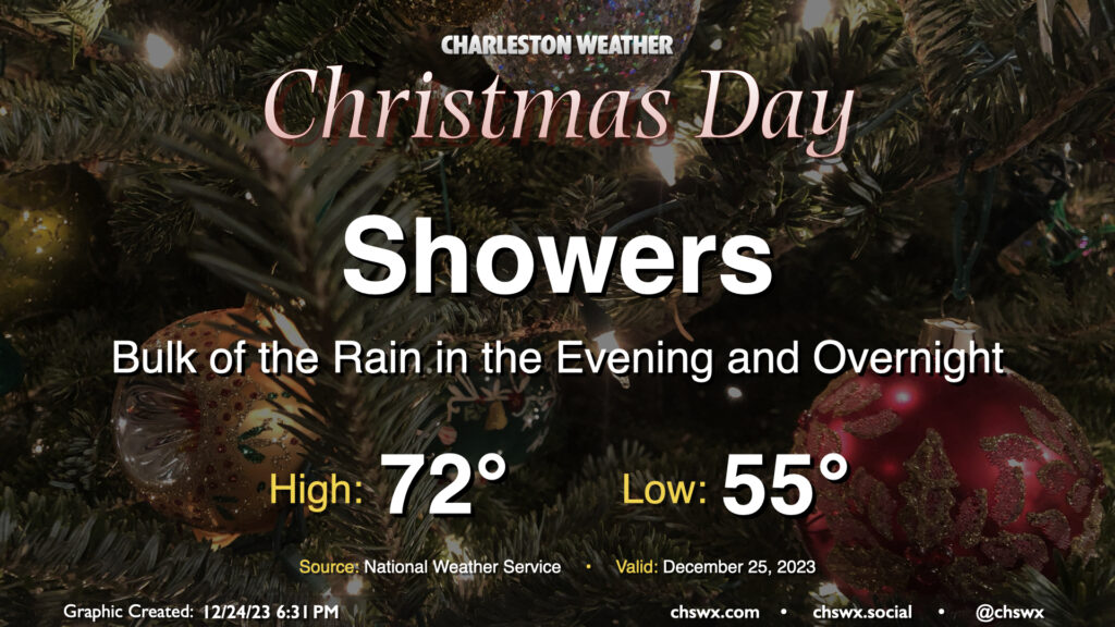
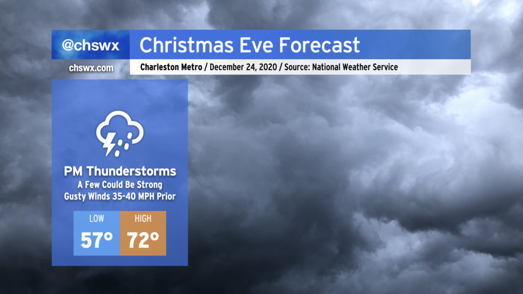
Unsettled weather arrives for Christmas as a complex and sprawling storm system begins to affect the area. We should see a few scattered showers in the morning through early afternoon, but expect shower coverage and intensity to tick up as we get further into the afternoon and evening hours. Temperatures on Christmas will run much warmer than climatology, though not into record territory. Expect lows in the mid-50s to yield to the low 70s in the afternoon before rain starts to kick in.
Water levels in Charleston Harbor look to reach flood stage (7′ MLLW) with the 6:30am high tide. This will put some salt water on some of the more vulnerable roads in Downtown Charleston, but no rain is expected to coincide, limiting the breadth of any flooding threat.
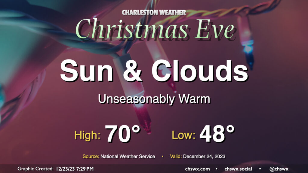
We have one more quiet day of weather ahead for Christmas Eve before a storm system starts to affect the area on Christmas Day. It’ll be an unseasonably warm Christmas Eve, that’s for sure: We start the day in the upper 40s to around 50° before warming to around 70° in the afternoon. The normal high for December 24 is 61°, while the low is typically closer to 41°. No records will be threatened, though: the record high of 80° set in 2015 remains safe.
The sky will generally feature a mix of sun and clouds. There is a small possibility a few showers could try to sneak onshore, so if you’re out at the coast or very nearby, don’t be surprised to get a light shower or two as a coastal trough develops. However, much of us will remain rain-free throughout the day and overnight, so there are no significant concerns for a certain sleigh aviator as he makes his rounds in our neck of the woods.
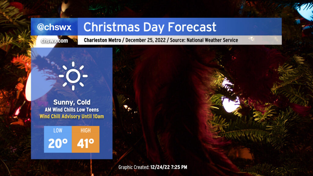
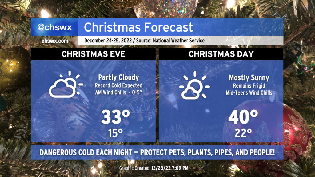
After record-breaking cold on Christmas Eve, we have another round of cold — but perhaps not quite as cold — weather for Christmas Day.
We begin the day with another Wind Chill Advisory as another round of low teens wind chills is forecast across the area. Air temperatures will drop to around 20°, with another dip into the teens possible further inland as well as in more rural areas. The good news is that after what should amount to about 40 consecutive hours below freezing, we will finally exceed the melting point by early afternoon, which will give us some much-needed thaw time. Skies will be mostly clear throughout the day, and at least some unfiltered sunshine will help it feel not as bitterly cold as it was on Saturday, though wind chills will still, at best, run in the low 30s.
Christmas weekend has arrived, and so has that unreal shot of Arctic air. Temperatures peaked around 56° at 8:49am just before the front passed by the airport. From there, temperatures have been steadily dropping throughout the day as dewpoints headed into the low single digits, making for a very dry feel to the air.
Details are coming into focus around what will be quite a strong storm for the Eastern Seaboard for Christmas Eve. Model guidance is in unanimous agreement for a strong band of showers and thunderstorms ahead of the cold front that could produce occasional damaging wind gusts during the afternoon and early evening hours. The good news is that this activity should get out of here by the time Santa is ready to make his rounds in the Lowcountry.
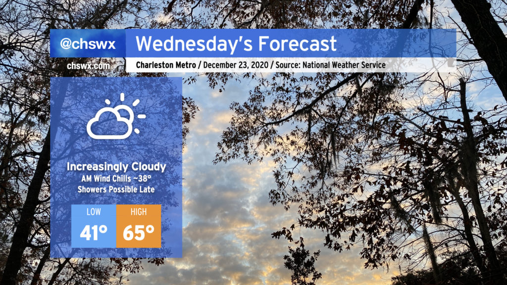
Wednesday will be the last rain-free shopping day before Christmas. Cloud cover will be filling in as the day goes on ahead of what looks to be a fairly potent storm system for Christmas Eve. Temperatures around the area will start out chilly — low 40s, with wind chills around 37-38° possible with a light breeze — before warming into the mid-60s despite the cloud cover. A shower or two can’t be ruled out closer to midnight Wednesday as well.