The week ahead: Last week of 2022 turns progressively warmer

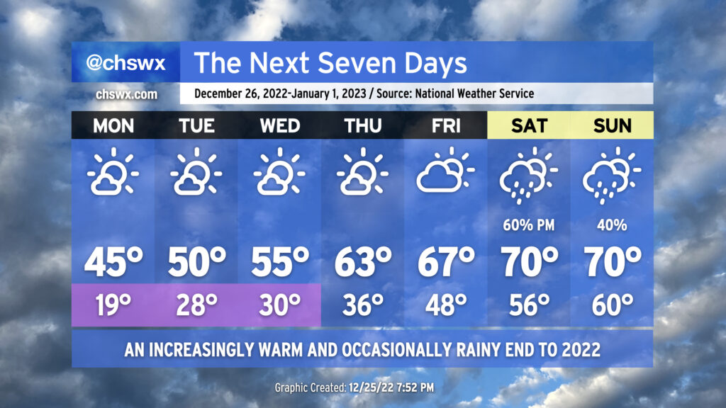
We begin the final week of 2022 with Arctic air continuing to make its presence felt across the area. We’ll start Monday in the upper teens to low 20s, with freezing temperatures all the way to the coast once again. It’ll be another night to make sure that pets, plants, and people are well accounted for, and that pipes are protected with extra insulation and a dripping faucet. Highs will top out again in the low-to-mid-40s under predominantly sunny skies.
The warming trend that started today, though, will continue through the rest of the week. Lows will continue to run below freezing Tuesday and Wednesday, but we’ll see highs climb into the low 50s on Tuesday, and then the mid-50s on Wednesday.
We cast aside freezing temperatures starting Thursday with highs rebounding into the low 60s in the afternoon. We’ll turn even warmer heading into Friday and New Year’s Weekend, with 60s expected Friday afternoon and 70s expected Saturday and Sunday.
Precipitation does return to the forecast over the weekend as a front approaches the area. Still some details to work out timing-wise, but the current forecast does show the best rain chances late Saturday into early Sunday, perhaps putting a bit of a damper on New Year’s celebrations. We’ll keep an eye on this, but for now, be ready for a little rain this weekend while rejoicing that we’ll be taking a break from the freezing temperatures for a while — in fact, long-range guidance suggests we stay above freezing through at least the second week of January, with a decent run of 70s to start 2023.
Follow my Charleston Weather updates on Mastodon, Bluesky, Instagram, Facebook, or directly in a feed reader. Do you like what you see here? Please consider supporting my independent, hype-averse weather journalism and become a supporter on Patreon for a broader look at all things #chswx!