The week ahead: Warm start to 2023 continues until a mid-week front
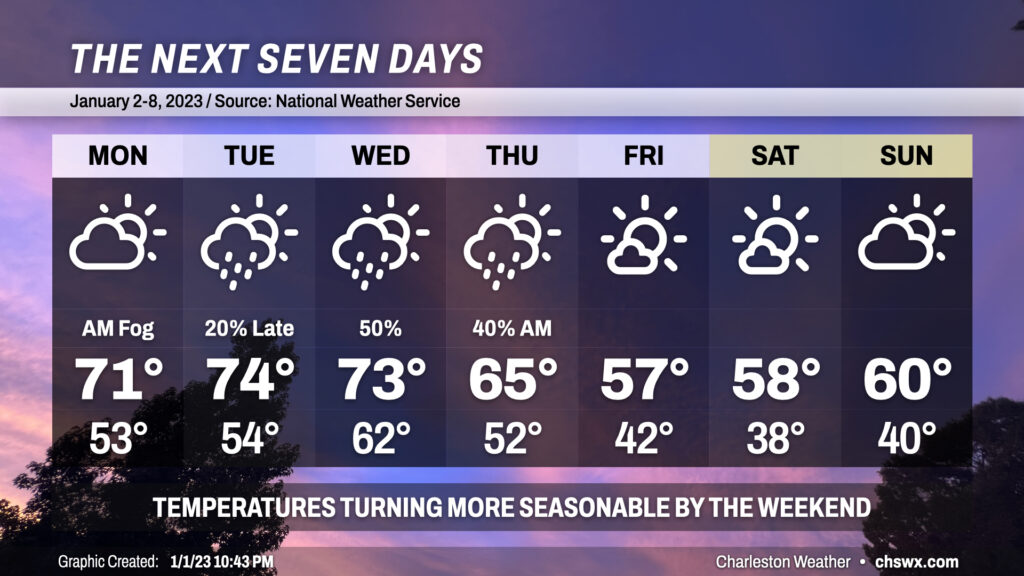
We’ve got a few more warm and muggy days ahead to start 2023 before a front gets through mid-week, bringing temperatures closer to early January normals.
We start the week with another round of dense fog. As of this writing, dense fog was blanketing a good bit of the Charleston metro area. A Dense Fog Advisory will be in effect until 10am. Use low beams and plenty of following distance to get where you need to get on Monday morning (though with the federal and state observance of New Year’s Day, we should hopefully see a little less traffic on the roads). Once fog mixes out, expect highs on Monday to once again climb into the low 70s, well above normal for the second of January.
Fog will be possible again Tuesday morning with similar conditions in place. With high pressure slipping further offshore and a front approaching, we’ll see even warmer weather with highs getting into the mid-70s. Shower chances enter the forecast in the evening hours, but the best risk for showers will be Wednesday as the front passes by. Wednesday will mark one more day of 70s to start the year before temperatures start to turn more seasonable by Thursday as the front gets by and cooler, drier air works its way in. We’ll be much closer to normal temperatures for Friday and the weekend, with brilliant sunshine and highs in the upper 50s to around 60° each day. Lows will run in the upper 30s to low 40s. (No freezing temperatures are forecast, though — much to the relief of local utilities, I’m sure.)
Follow my Charleston Weather updates on Mastodon, Bluesky, Instagram, Facebook, or directly in a feed reader. Do you like what you see here? Please consider supporting my independent, hype-averse weather journalism and become a supporter on Patreon for a broader look at all things #chswx!