The week ahead: Unsettled, though we could use the rain
“Unsettled” is probably the best way to put this week’s forecast as we expect periods of showers throughout the period.
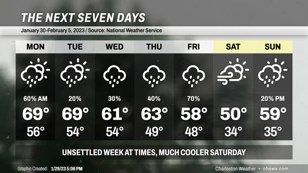
Showers ongoing Sunday night into Monday will scour out by mid-morning, yielding a mix of clouds and sun for Monday afternoon with highs approaching 70°. Isolated to scattered showers re-enter the forecast for Tuesday as a front approaches the area and slows down, but a washout doesn’t appear likely at this point. Said cold front pushes south of the area and high pressure wedges in for Wednesday, cooling us off somewhat and socking us in with overcast for the better part of a couple days. Lift atop the wedge will keep the risk for scattered showers in the forecast through Thursday. Shower chances then ramp back up into the likely category for Friday as low pressure slides south of the area, driving one more front through the area before the weekend. It’ll cool off substantially on Saturday despite mostly sunny skies, as breezy conditions keep highs suppressed to around 50° in the afternoon. Wedging may re-establish itself Sunday, bringing a slight chance of showers back into the equation as a trough possibly develops nearby.
Overall, we could continue to use the rain as moderate drought continues across the Lowcountry. It doesn’t look like we’re going to get too much too fast, either, keeping the risk for rainfall flooding to a dull roar.
Follow my Charleston Weather updates on Mastodon, Bluesky, Instagram, Facebook, or directly in a feed reader. Do you like what you see here? Please consider supporting my independent, hype-averse weather journalism and become a supporter on Patreon for a broader look at all things #chswx!