Rest of the work week: Brief rain respite Wednesday, but showers return ahead of the weekend
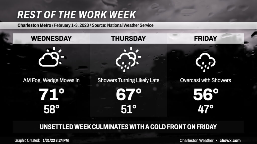
After a soggy couple days, we get a respite from some of the rain on Wednesday as we sit between storm systems and high pressure sinks south across the area. Fog may be an issue in the morning once again, so be ready with the low beams and a little extra time to get where you’re going. Temperatures should peak in the low 70s in the afternoon before cooler high pressure and an associated wedge front press southward across the area later in the day. It remains to be seen just how far south the wedge can get, but expect it to help cool temperatures to around 50° in the morning on Thursday.
I’d consider mid-60s to be a best-case scenario for temperatures on Thursday as it will be highly dependent on the position of the wedge front. It is expected to lift a little more northward as a warm front during the day Thursday with shower chances throughout the day. However, rain chances tick up later in the day into the overnight, and the rain falling into the cool wedge should strengthen it and allow it to sink back into the Lowcountry by evening. We stay wedged in Friday as showers move across the area for a majority of the day ahead of a storm system. It’ll be chilly on Friday, with lows in the upper 40s giving way to highs in the mid-50s at best with rain blanketing the area as low pressure traverses the Gulf Coast and moves across the Florida panhandle, staying south of us and keeping us in the cool sector.
Chilly weather continues into Saturday, though with a much-needed shot of sunshine before another storm system begins to affect the area on Sunday. For now, though, keep the rain gear nearby!