The week ahead: Unseasonable warmth returns
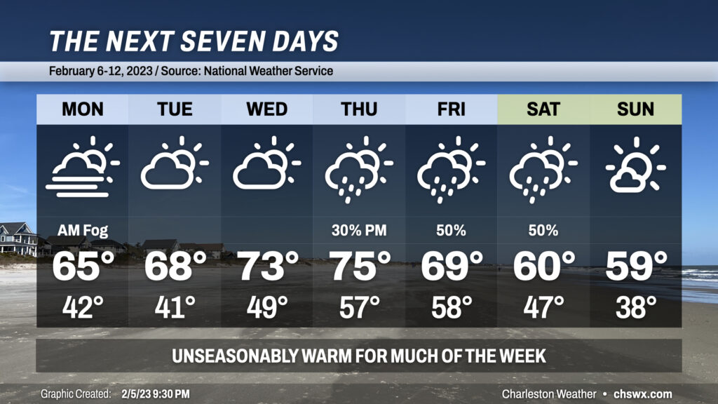
Unseasonable warmth lies ahead for a good chunk of the upcoming work week before showers, maybe some storms, and then more seasonable temperatures arrive for the weekend.
First off, there’s some hazardous weather tonight: Watch out for dense fog tonight into early tomorrow morning before conditions improve around sunrise.
We start Monday in the low 40s on our way to the mid-60s in the afternoon on what will turn out to be a nice, sunny day in the Lowcountry as high pressure is the main player in our weather throughout the day. Said high pressure begins to head offshore Tuesday into Wednesday, shifting winds more southerly and turning on the heat pump as a result: upper 60s on Tuesday give way to low-to-mid-70s on Wednesday under partly cloudy skies.
The next storm system begins to affect the area Thursday. We’ll stay quite warm, starting the day in the upper 50s on our way to around 75° or so despite mostly cloudy skies. Showers and maybe a thunderstorm become possible later in the day as a front shifts closer to the area. Expect much of the rain to fall on Friday with a few thunderstorms possible and highs topping out around 70°.
Changes come behind a cold front beginning Saturday; we’ll see shower chances taper off in the morning, but it’ll be much cooler come afternoon with highs only topping out around 60°. Sunday will live up to its name pretty well, with mostly sunny skies and highs once again approaching 60° as high pressure takes control once more.
Follow my Charleston Weather updates on Mastodon, Bluesky, Instagram, Facebook, or directly in a feed reader. Do you like what you see here? Please consider supporting my independent, hype-averse weather journalism and become a supporter on Patreon for a broader look at all things #chswx!