The week ahead: Record warmth possible with May-like temperatures
High pressure at the surface and aloft will keep very warm temperatures in the forecast for much of the week with no rain to show for it as strong subtropical ridging more characteristic of late spring/summer builds across the area. Put another way: It’s a scary week to be a record high at the North Charleston climate site.
Record highs to be threatened Tuesday-Friday
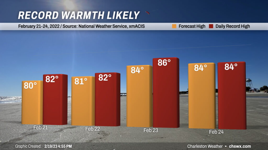
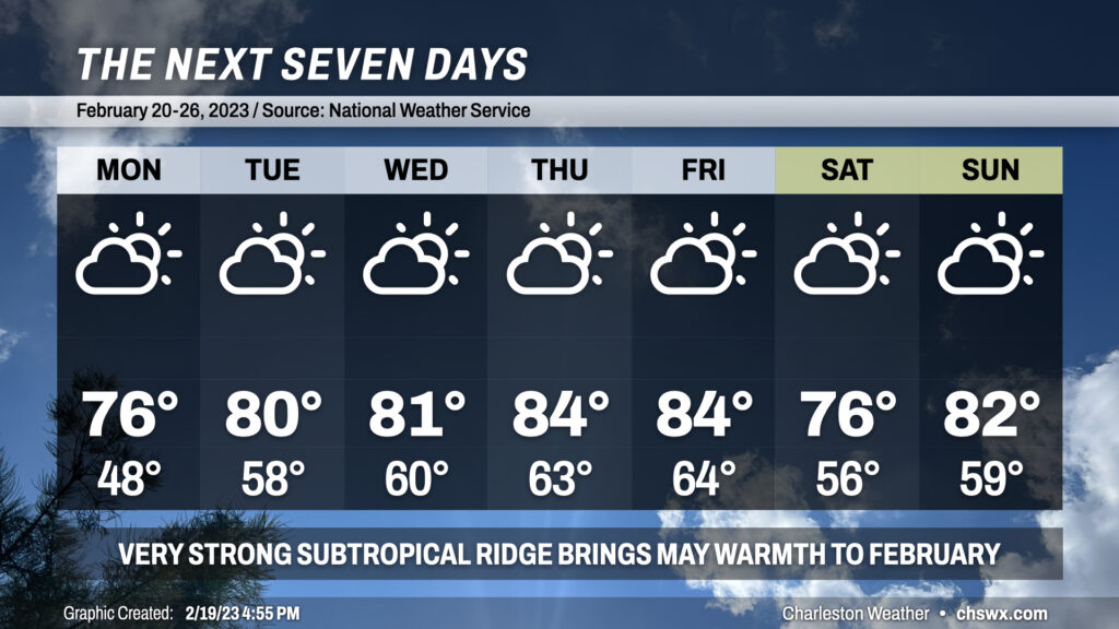
After an unseasonably warm but non-record-threatening Monday, the temperatures will really turn up heading into mid-week. We’ll enter a stretch of a few days where record highs look to be quite under siege starting Tuesday when highs top out in the low 80s, challenging the record high of 82° set in 2019. We’ll see similar warmth Wednesday, approaching the record of 82° set in 2018. The peak of the warmth arrives Thursday and Friday as highs soar into the mid-80s. The current NWS forecast for Thursday falls just short of the record high of 86° set just last year, while Friday’s ties the high of 84°, also set last year.
Climatological 30-year normals from 1991-2010 yield typical highs in the mid-60s at this point late in February. So, while this is certainly unusual warmth in the grand scheme of things, it also is worth noting just how recently these records were set — 2018, 2019, and 2022 — making this warmth not that unusual in recent years.
It’s worth noting that it’ll be cooler at the beaches and in downtown Charleston, but not uncomfortably so — highs will generally run in the mid-to-upper 70s for much of the week.
Brief cooldown for the weekend
We could be in for a brief cooldown this weekend as a backdoor cold front sinks close to the area. There’s some model disagreement about just how far south the front can make it; the ECMWF ensembles are more bullish about getting the front south of here, putting us in the 60s for Saturday, while the GFS and its ensembles keep it to the north, holding temperatures in the mid-to-upper 70s. For its part, NWS has gone with the warmer solution for now given the continued strength of the ridge aloft. Stay tuned, though, as there’s some uncertainty here. Regardless, it does look like temperatures rebound quickly on Sunday, perhaps back into the 80s (and threatening another record high). Rain chances are near nil despite the front’s proximity.
Rare February air
Overall, it’s been a very warm February, so much so that we’ve not recorded a 32° or below reading at any point this month at the airport. (We got close with a low of 33° on February 4.) It looks quite clear that we won’t dip this low at any point for the rest of the month, so there’s good confidence in saying that this will only be the fifth February since records began in 1938 where the airport failed to record a freezing-or-below temperature. The previous years are 1948, 1992, 2017, and 2018.
Resist the temptation to plant early, though. Two of those four prior years featured freezes in March, including a particularly hard freeze in 2017, while temperatures reached frost-capable lows all four years. There’s still plenty of time for a pattern change to bring us one more shot of cold before spring kicks in for real from late March on.
Follow my Charleston Weather updates on Mastodon, Bluesky, Instagram, Facebook, or directly in a feed reader. Do you like what you see here? Please consider supporting my independent, hype-averse weather journalism and become a supporter on Patreon for a broader look at all things #chswx!