The week ahead: Stormy start, cooling off, but warming back up for the Bridge Run
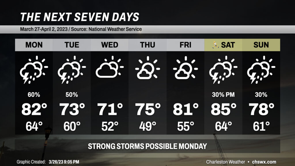
The week ahead will get off to a rather stormy start as a stalled front continues to keep the risk for showers and thunderstorms in the forecast through Tuesday, a few of which could be on the strong to severe side (especially on Monday). We cool off briefly mid-week before 80s return ahead of another front for the weekend, making for a possibly muggy Bridge Run.
Overnight: Showers and thunderstorms possible
A few showers and thunderstorms will be possible overnight into tomorrow morning, especially as you get closer to I-95 in Berkeley and Dorchester counties. A strong or severe storm can’t be totally discounted given an improving environment for thunderstorm development and maintenance. For its part, the Storm Prediction Center is maintaining a slight risk of severe weather across the area, with large hail and damaging winds the main risks. A tornado can’t be totally ruled out, either. That being said, guidance generally agrees that the bulk of this activity stays to our north tonight.
Quick cooldown ahead after this round of storms
The atmosphere on Monday could once again become favorable for strong to severe storms as a cold front approaches from the west. Damaging wind gusts and large hail will remain the primary concerns, with a tornado not totally out of the picture, either. Ahead of the front and its associated storms, expect highs in the low 80s with gusty southwest winds.
The front will pass through and stall out south of us on Tuesday. Energy rippling through the mid-levels will help spawn additional showers and maybe even a few thunderstorms across the area, but the severe risk will be much lower given somewhat cooler air behind the front. Highs top out in the low 70s Tuesday as opposed to the low 80s on Monday.
We finally give all this bad weather a good shove and get a few quiet days in for Wednesday through Friday. Wednesday will be rather refreshing with highs topping out in the low 70s as a drier airmass takes hold. We warm to the mid-70s on Thursday and back into the low 80s on Friday ahead of the next front. We should stay rain-free but muggy for the Bridge Run on Saturday morning, with a slight chance of storms late in the day that will continue into Sunday.
Follow my Charleston Weather updates on Mastodon, Bluesky, Instagram, Facebook, or directly in a feed reader. Do you like what you see here? Please consider supporting my independent, hype-averse weather journalism and become a supporter on Patreon for a broader look at all things #chswx!