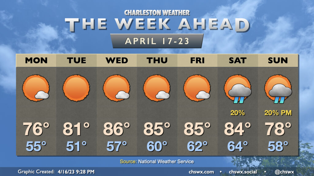
The week ahead: A whole lot of sunshine — and 80s

There’s not much to write about this week, weather-wise. A cold front coming through overnight Sunday will give way to expansive high pressure that will dominate the weather conversation for the next several days, primarily around just how much sunshine there’s going to be along with above-normal temperatures for mid-late April.
Monday will be the coolest day of the set. We’ll start in the mid-50s and warm into the mid-70s. Dewpoints mixing out into the mid-30s thanks to westerly-to-northwesterly winds will help drive relative humidity values to around 25% in the afternoon away from the coast. The seabreeze will have a tough time getting too much inland penetration, which will keep those dewpoints nice and low throughout the day.
We start out with another cool morning on Tuesday as lows bottom out in the low 50s. High pressure looks to move generally overhead, allowing temperatures to rise to around 80° in the afternoon. Winds go a little more southerly on Wednesday, bringing in a little warmer air; temperatures respond with highs in the mid-80s through the end of the week with just a few clouds as high pressure hangs on.
A few showers will be possible Saturday and Sunday as another cold front approaches the area, but right now it’s not looking like it’ll be terribly disruptive with the better forcing staying to the north near the parent low. Saturday will be the warmer of the two days as the front more directly affects the area Sunday with an influx of cooler and drier air expected behind the front…which will probably give us another beautiful Monday we’d have preferred a day or two earlier.
Follow my Charleston Weather updates on Mastodon, Bluesky, Instagram, Facebook, or directly in a feed reader. Do you like what you see here? Please consider supporting my independent, hype-averse weather journalism and become a supporter on Patreon for a broader look at all things #chswx!