Rest of the work week: Turning unsettled with periods of showers and storms
We’ll see steadily more unsettled weather as we head into the second half of the work week as a series of storm systems impacts the area.
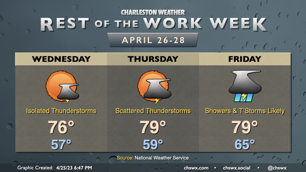
High pressure to the north will weaken, allowing a coastal trough to move inland throughout the day Wednesday. This should trigger some afternoon showers and maybe even a few thunderstorms. Temperatures start in the mid-50s before topping out in the mid-70s. No rainout is expected, but you’ll want to keep an eye out in case a shower or storm moves toward your location.
We should see an uptick in coverage Thursday afternoon and evening as a cold front gets closer to the area. Scattered thunderstorms become possible late in the day, and rain chances will increase overnight especially as we get into the warm sector of the incoming storm system. Highs on Thursday top out in the upper 70s.
Friday could be the soggiest of the set. Recent guidance tamps down on how long precipitation is in the area somewhat, but the forecast for now remains for numerous showers and thunderstorms. It’ll be a warm and humid day regardless, with highs still expected to top out around 80° after starting the day in the mid-60s. Keep an eye on forecast updates for more fine-tuning around timing of the bulk of the rain.
Follow my Charleston Weather updates on Mastodon, Bluesky, Instagram, Facebook, or directly in a feed reader. Do you like what you see here? Please consider supporting my independent, hype-averse weather journalism and become a supporter on Patreon for a broader look at all things #chswx!