The week ahead: Summer begins to break through

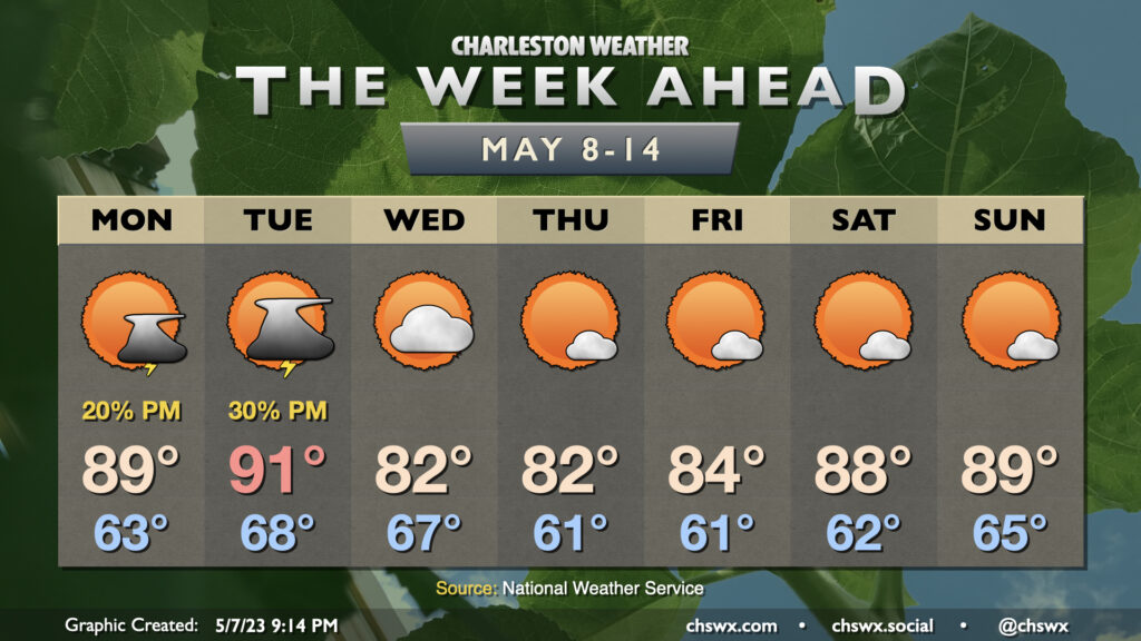
We’ll get a good summer preview to start and finish the upcoming week, with a lull in the middle with slightly cooler high pressure building in behind a front for mid-week.
First, though, we have a very warm start to the week ahead. We’ll flirt with 90° on Monday and should top out in the low 90s on Tuesday, which would be the first 90° reading of the year. The mean date for the first 90° temperature at Charleston Int’l Airport is May 5, so we’re right around the average as far as climatology goes. Isolated to scattered showers and thunderstorms will be possible both Monday and Tuesday afternoons, but not everyone sees rain. An isolated severe storm can’t be ruled out Tuesday with the front sagging south, so we’ll keep an eye on that.
Once the front is through, we get a little cooler air work into the area for mid-week as winds go northeast to east. After a warm start to Wednesday in the upper 60s, temperatures top out only in the low 80s with a few clouds. Same goes for Thursday, save for a cooler start in the low 60s. We warm slightly Friday as high pressure starts to trend offshore, but otherwise nice conditions with just a few clouds continue.
Temperatures will head back up heading into the weekend as ridging builds aloft and high pressure slips back out into the Atlantic. We’ll once again flirt with 90° each afternoon, though rain chances look minimal as of right now. As we get into this point in the year, one can never totally discount a popup storm or two. However, it’s certainly nice to not have mentionable precipitation probabilities over the weekend — a very, very rare sight thus far in 2023.
Follow my Charleston Weather updates on Mastodon, Bluesky, Instagram, Facebook, or directly in a feed reader. Do you like what you see here? Please consider supporting my independent, hype-averse weather journalism and become a supporter on Patreon for a broader look at all things #chswx!