The week ahead: Feeling a little more like June
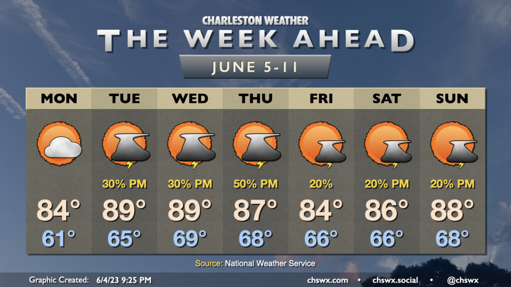
After a prolonged period of below-normal temperatures (not that a lot of us are complaining, mind you), temperatures will begin to feel a little more like June at times this week as the series of cool high pressure wedges takes a little breather. The warming trend starts Monday, as highs top out in the mid-80s — still a little below normal, but much closer than we saw on Sunday with a high of only 75°. Skies will be partly cloudy to mostly sunny, another nice change from Sunday’s generally overcast disposition.
Afternoon shower and thunderstorm chances return to the forecast beginning Tuesday and lasting into the weekend as temperatures return to the upper 80s and perhaps even flirt with 90°. Meanwhile, we remain on the southern periphery of a broad trough of low pressure aloft, and that will help bring some energy into the area from time to time, particularly on Thursday when models suggest a vigorous shortwave trough may glance the area and help improve the coverage of scattered thunderstorms in the afternoon and evening hours. This could also drive a front through, which will knock temperatures back to the mid-80s for Friday and Saturday before warming back to the upper 80s for Sunday.
Coastal flood threat continues, but diminishes, Monday into Tuesday
The risk for coastal flooding around the evening high tides continues through Tuesday. Sunday evening’s high tide peaked at 8.37′, which is good for 13th highest on record (records begin fall of 1922) and easily blows by June 22, 2009’s peak of 8.11′ for highest on record in the month of June.
Moderate coastal flooding appears likely on Monday evening, with the total water level approaching 7.7-7.9′ around the 10:02 PM high tide. This could spur on another round of road closures and other disruptions, but won’t be as significant as Sunday night’s tide.
Tuesday evening’s tide, which should peak just before 11PM, will be capable of producing minor salt water flooding, and a brief round may yet be possible with the midnight-ish tide Wednesday. Overall, though, the trend is downward as we move away from the full moon and winds become less favorable for piling water into the harbor.
Follow my Charleston Weather updates on Mastodon, Bluesky, Instagram, Facebook, or directly in a feed reader. Do you like what you see here? Please consider supporting my independent, hype-averse weather journalism and become a supporter on Patreon for a broader look at all things #chswx!