Rest of the work week: Pretty standard July days

Not too much to write home about in the weather department for the rest of the work week — just more in the way of heat, humidity, and a slight uptick in showers and storms as we head toward Friday.
Air temperature-wise, Wednesday will be the warmest day of the rest of the work week with highs topping out in the mid-90s. However, drier mid-level air will mix down to the surface during the heat of the day, and this will help keep heat indices around 100-101°. (Not great, but it could be worse.) The aforementioned dry mid-levels should keep most, if not all, shower and storm activity at bay, though you can never truly rule any stray shower or storm out during this point of the year.
Moisture starts to return Thursday, and this manifests itself with a little higher heat index in the afternoon — approaching 105° — and a slightly better (but still low) chance of seabreeze thunderstorms. Friday could see a little better coverage of afternoon thunderstorms as heat indices top out over 105° at peak heating. (Remember, heat advisory criteria for July 1 and beyond is 110° for two hours.) Overall, there’s nothing in this forecast that’s terribly out of bounds for this point in the year — just mind the heat and be ready to head inside if a thunderstorm gets close.
Tropical update: A few waves, but nothing imminent
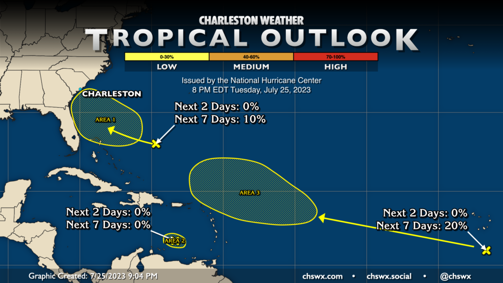
NHC continues to watch a couple areas in the Atlantic for development, and has written off a third that had some promise last week but has since run into the buzzsaw that is wind shear over the Caribbean.
The first area is a trough of low pressure southwest of Bermuda that’s headed toward the Southeast US coast. However, it looks very unlikely to turn into much of anything more than a moisture enhancer, and NHC only gives it a 10% chance of development over the next seven days. While it looks a little ominous to have an area being watched near us here at home, there’s nothing to worry about at this point.
The second area is the aforementioned disturbance that had as high of a 70% chance of development at one point, but as mentioned, wind shear has essentially cut out much of any chance of this to develop. NHC gives it a big fat goose egg — 0% — over the next two and seven days. (In fact, I had to tweak my map to even get it to show up!)
Finally, a third wave south of the Cabo Verde Islands could run into some favorable conditions for development as it gets into the central Atlantic by the weekend. NHC is giving it a 20% chance to develop at this point, but there’s a lot of time to watch and see what it ends up doing. In the meantime, there’s no imminent concerns for the Lowcountry.
Follow my Charleston Weather updates on Mastodon, Bluesky, Instagram, Facebook, or directly in a feed reader. Do you like what you see here? Please consider supporting my independent, hype-averse weather journalism and become a supporter on Patreon for a broader look at all things #chswx!