The week ahead: All eyes on Idalia

Much of the weather scuttlebutt this week will be about Tropical Storm Idalia, which increasingly looks like it’s going to have impacts on the area Wednesday into Thursday. We have a couple reasonably quiet days ahead before the weather begins to head downhill later Tuesday night. Expect highs on Monday to top out in the low 90s with just a slight chance of an afternoon shower or thunderstorm along the seabreeze; it’ll be a similar story for a good bit of Tuesday before moisture from Idalia potentially triggers a predecessor rain event along and ahead of a stalled front, which could bring very heavy rain to some spots and maybe even some flooding ahead of the storm’s arrival.
Idalia’s impacts Wednesday and Thursday
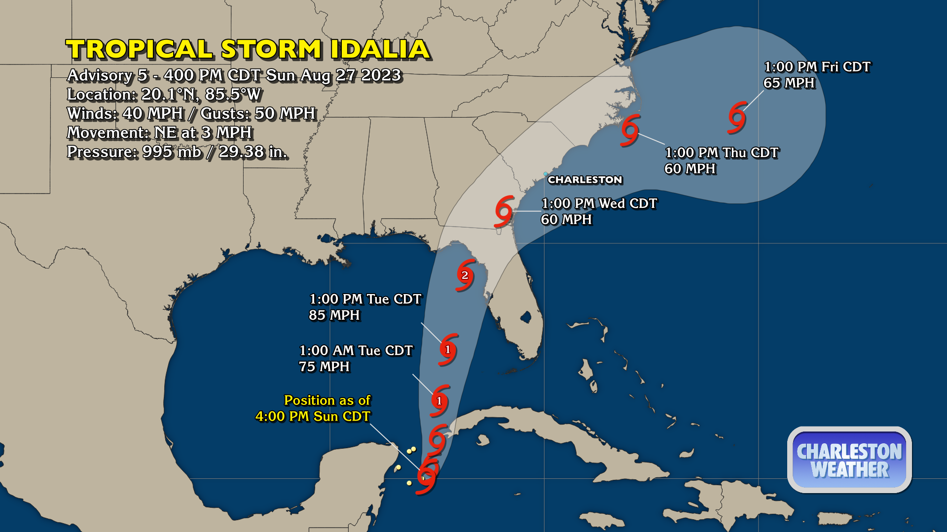
On the current NHC track, the forecast will show that the peak impacts from Idalia will arrive on Wednesday and depart by Thursday as the storm is forecast to accelerate to the northeast around a building ridge of high pressure in the Atlantic. This would increase rain and wind throughout Wednesday, with tropical storm force winds possible as the day goes on.
It remains to be seen just how much Idalia will coincide with what is expected to be a rather high tide on Wednesday evening (8:24 PM, to be exact), as the full moon at perigee will already be sending us into coastal flood with evening high tides possibly as soon as Monday. Persistent onshore wind on the north side of Idalia’s circulation will help to push water levels higher. This, combined with periods of heavy rain, could portend a significant flooding threat across the area late Tuesday through early Thursday, with the risks maximized around times of high tide.
All that said, the exact magnitude of the impacts is just not knowable yet. A lot will depend on how strong and fast Idalia comes in, and NHC has been continuing to revise the intensity forecast upward throughout the day, now having it making landfall as a Category 2 storm in Florida on Tuesday. Given how much and how deep the warm water goes in the Gulf, it is possible we could see even further upward revisions to the intensity forecast despite some shear. There’s still a fairly significant delta between the ECMWF and GFS solutions; the former takes Idalia parallel to the coast but to our east, while the GFS keeps it moving across the Midlands, keeping us on the dirty side of the storm. Big changes to impacts could result due to tiny track changes, so please be patient as the forecast impacts are fine-tuned.
Bottom line for now: Expect an increasingly windy day Wednesday into Wednesday night, with bands of heavy rain possible through Thursday. Significant coastal flooding is certainly a possibility, along with beach erosion and strong rip currents.
Be preparing for: Power outages (some possibly lasting hours), tree and power line damage, and long-duration flooding in vulnerable locations, which might cut off roads. If you need help putting together a hurricane kit, I strongly recommend visiting SCEMD’s hurricane preparedness website, hurricane.sc.
Finally, check back on forecast updates periodically. Things can and will still change. You don’t have to check every hour, and I definitely wouldn’t recommend trying to interpret the weather models. The National Hurricane Center and National Weather Service local forecasts are your best guide, and that’s what I relay here. It’s important not to get latched onto the forecast as it can and will change (and, with any luck, get more precise, too).
Better by Friday and the weekend
After Idalia departs, we look to have several fairly nice weather days across the area as cooler and drier air filters in. We may see a few spots bottom out in the upper 60s Friday and Saturday mornings, with highs in the mid-80s expected Friday and upper 80s on Saturday before the 90s return for Sunday with plenty of sunshine throughout.
Follow my Charleston Weather updates on Mastodon, Bluesky, Instagram, Facebook, or directly in a feed reader. Do you like what you see here? Please consider supporting my independent, hype-averse weather journalism and become a supporter on Patreon for a broader look at all things #chswx!